|

United Kingdom : England
near Lowdham, Nottinghamshire, England, United Kingdom
Approx. altitude: 19 m
(62 ft)
([?] maps: Google MapQuest OpenStreetMap ConfluenceNavigator)
Antipode: 53°S 179°E
Accuracy: 5 m (16 ft)
Quality: good
Click on any of the images for the full-sized picture.


| 53°N 1°W (visit #2) |
![Visit #31: [01-Aug-23]](/uk/en/n53w001v31/preview.jpg "Visit #31: [01-Aug-23]")
![Visit #29: [02-Oct-21]](/uk/en/n53w001v29/preview.jpg "Visit #29: [02-Oct-21]")
![Visit #30: [05-Sep-19]](/uk/en/n53w001v30/preview.jpg "Visit #30: [05-Sep-19]")
![Visit #27: [28-Jun-14]](/uk/en/n53w001v27/preview.jpg "Visit #27: [28-Jun-14]")
![Visit #26: [12-Jan-13]](/uk/en/n53w001v26/preview.jpg "Visit #26: [12-Jan-13]")
![Visit #25: [29-Mar-12]](/uk/en/n53w001v25/preview.jpg "Visit #25: [29-Mar-12]")
![Visit #24: [08-Oct-11]](/uk/en/n53w001v24/preview.jpg "Visit #24: [08-Oct-11]")
![Visit #23: [01-Oct-11]](/uk/en/n53w001v23/preview.jpg "Visit #23: [01-Oct-11]")
![Visit #22: [02-Jul-11]](/uk/en/n53w001v22/preview.jpg "Visit #22: [02-Jul-11]")
![Visit #21: [19-Aug-10]](/uk/en/n53w001v21/preview.jpg "Visit #21: [19-Aug-10]")
![Visit #20: [24-Jun-10]](/uk/en/n53w001v20/preview.jpg "Visit #20: [24-Jun-10]")
![Visit #19: [24-Jun-10]](/uk/en/n53w001v19/preview.jpg "Visit #19: [24-Jun-10]")
![Visit #18: [16-Apr-10]](/uk/en/n53w001v18/preview.jpg "Visit #18: [16-Apr-10]")
![Visit #16: [18-Sep-09]](/uk/en/n53w001v16/preview.jpg "Visit #16: [18-Sep-09]")
![Visit #17: [14-Sep-09]](/uk/en/n53w001v17/preview.jpg "Visit #17: [14-Sep-09]")
![Visit #15: [21-May-09]](/uk/en/n53w001v15/preview.jpg "Visit #15: [21-May-09]")
![Visit #14: [30-Nov-08]](/uk/en/n53w001v14/preview.jpg "Visit #14: [30-Nov-08]")
![Visit #13: [08-Jun-08]](/uk/en/n53w001v13/preview.jpg "Visit #13: [08-Jun-08]")
![Visit #12: [04-Apr-08]](/uk/en/n53w001v12/preview.jpg "Visit #12: [04-Apr-08]")
![Visit #11: [04-Apr-08]](/uk/en/n53w001v11/preview.jpg "Visit #11: [04-Apr-08]")
![Visit #10: [17-Oct-07]](/uk/en/n53w001v10/preview.jpg "Visit #10: [17-Oct-07]")
![Visit #9: [12-Jun-05]](/uk/en/n53w001v9/preview.jpg "Visit #9: [12-Jun-05]")
![Visit #7: [09-Jan-05]](/uk/en/n53w001v7/preview.jpg "Visit #7: [09-Jan-05]")
![Visit #8: [02-Jan-05]](/uk/en/n53w001v8/preview.jpg "Visit #8: [02-Jan-05]")
![Visit #6: [17-Oct-04]](/uk/en/n53w001v6/preview.jpg "Visit #6: [17-Oct-04]")
![Visit #5: [20-Mar-04]](/uk/en/n53w001v5/preview.jpg "Visit #5: [20-Mar-04]")
![Visit #4: [15-Nov-03]](/uk/en/n53w001v4/preview.jpg "Visit #4: [15-Nov-03]")
![Visit #3: [14-Nov-02]](/uk/en/n53w001v3/preview.jpg "Visit #3: [14-Nov-02]")
![Visit #1: [25-Jun-00]](/uk/en/n53w001/preview.jpg "Visit #1: [25-Jun-00]")
![Visit #28: [23-Dec-19]](/uk/en/n53w001v28/preview.jpg "Visit #28: [23-Dec-19]")

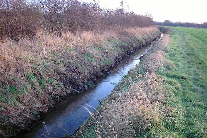
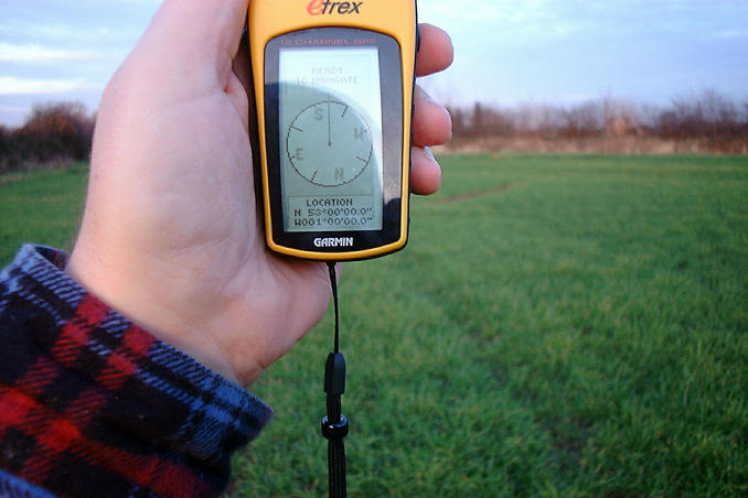
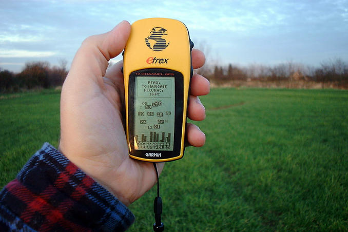
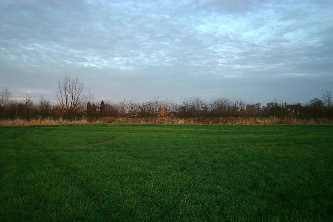
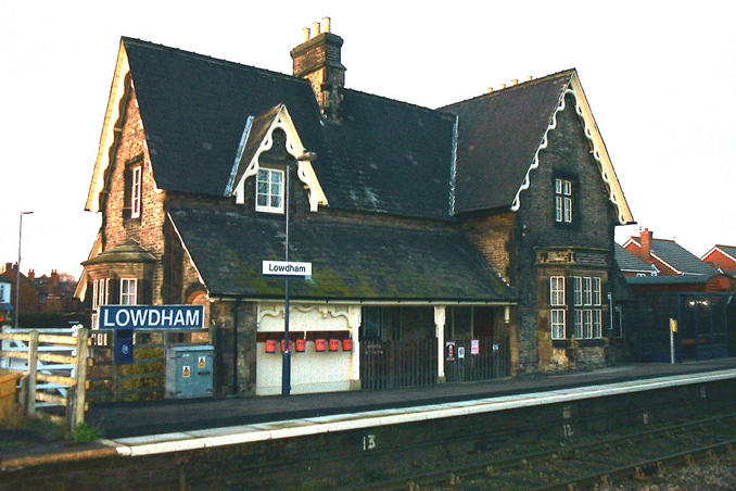
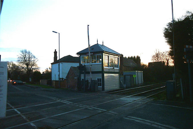
(visited by Gordon Spence, Craig Spence and Nicola Spence) 16-Dec-2001 -- Well, guess what? That's right, it is time to visit my children again, so that must also mean it's confluence time right? The only problem is they are getting further and further away now, this one is over 70 miles (as the crow flies), oh well, we have all day after all. Setting off at about 10am, we have a brief argument about who is going to sit in the front of the car and who in the back, teenagers eh? I sorted it out by flipping a coin and they could swap on the way back! It was a lovely dry, suuny, but cold day - just above freezing. Well it seemed cold, having spent so much time this year in either Tampa or San Jose.... About two hours later we arrive in the general vicinity, I have got Nicola on the GPS counting us down, when she suddenly announces "We've gone past it!", on half a mile to turn around....then park up opposite the house noted by the previous visitor. I went to knock, just to confirm, now I don't know whether the guy thought I was selling something but he was apparently "just on his way to work", at 12.30 Saturday lunchtime? When I explained what I was doing he relaxed and confirmed it was owned by the Water Authority. Now I don't know what it is with us and fields, but this one had a light covering of grass, but underfoot was six inches of thick sticky clay. Walk around to the back of the field and I realise we are about 80-90 feet short, in the way is a thick hedge, the other side of which is a wide water filled ditch. I noticed from the web site that the last visitor gave the accuracy as 100 feet...hmmm Not being one to give up, we set off to the left to find a way around the obstacle, 400 yards later there was a path across it - the really funny thing is we could have driven to that spot and parked up! Across we go and back the way we came. Five minutes later and we were on the exact spot. How close? spot on, how accurate? 16 feet. Time for the location shot, looking North, the house we called at to check who owned the land is on the right of the picture. It was time for a late lunch, where we turned around was a small village with a historic style of railway station, you can clearly see the fire buckets on the wall, a relic from the days when trains were steam powered! On the other side of the road was an even rarer item, a manual signal box, just about all signals and crossings are automatic nowadays, so this was quite a rare find. But wait, there is a twist to this tail. I was downloading and captioning the photo's when my pc threw a wobbly and deleted all the files fom the Smartmedia card....every single one. So how can you see them here? I went back again today, just to take the pictures, this time from home, was it far? round trip of 175 miles! |
| All pictures |
| #1: Looking North #2: On the exact spot #3: Accuracy #4: Jump that! #5: Lowdham station #6: Signal box ALL: All pictures on one page |