|

Germany : Sachsen-Anhalt
near Moritz-Schora, Sachsen-Anhalt, Germany
Approx. altitude: 74 m
(242 ft)
([?] maps: Google MapQuest OpenStreetMap ConfluenceNavigator)
Antipode: 52°S 168°W
Accuracy: 32 m (104 ft)
Quality: good
Click on any of the images for the full-sized picture.


![]()
| 52°N 12°E (visit #3) |
![Visit #15: [27-Jul-25]](/de/all/n52e012v15/preview.jpg "Visit #15: [27-Jul-25]")
![Visit #14: [26-Jul-22]](/de/all/n52e012v14/preview.jpg "Visit #14: [26-Jul-22]")
![Visit #12: [06-Aug-20]](/de/all/n52e012v12/preview.jpg "Visit #12: [06-Aug-20]")
![Visit #11: [06-Apr-14]](/de/all/n52e012v11/preview.jpg "Visit #11: [06-Apr-14]")
![Visit #10: [25-Jul-13]](/de/all/n52e012v10/preview.jpg "Visit #10: [25-Jul-13]")
![Visit #9: [15-Jun-13]](/de/all/n52e012v9/preview.jpg "Visit #9: [15-Jun-13]")
![Visit #13: [13-Sep-12]](/de/all/n52e012v13/preview.jpg "Visit #13: [13-Sep-12]")
![Visit #8: [28-Oct-11]](/de/all/n52e012v8/preview.jpg "Visit #8: [28-Oct-11]")
![Visit #7: [13-Mar-10]](/de/all/n52e012v7/preview.jpg "Visit #7: [13-Mar-10]")
![Visit #6: [19-Apr-09]](/de/all/n52e012v6/preview.jpg "Visit #6: [19-Apr-09]")
![Visit #5: [25-May-06]](/de/all/n52e012v5/preview.jpg "Visit #5: [25-May-06]")
![Visit #4: [21-Aug-02]](/de/all/n52e012v4/preview.jpg "Visit #4: [21-Aug-02]")
![Visit #2: [16-Apr-01]](/de/all/n52e012v2/preview.jpg "Visit #2: [16-Apr-01]")
![Visit #1: [07-Apr-01]](/de/all/n52e012/preview.jpg "Visit #1: [07-Apr-01]")

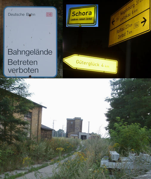
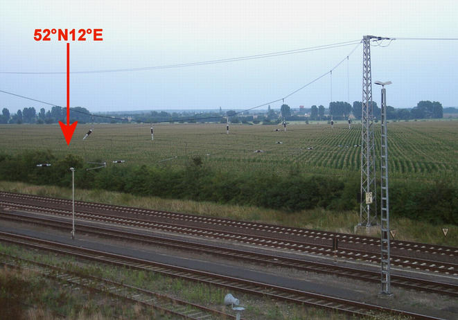
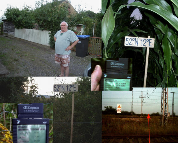
(visited by Hans Augdoppler) 14-Aug-2001 -- On this hot summer day I decided to visit this confluence after my duty in Brandenburg. I headed southwest in direction Magdeburg (which I know from Karl May’s novels) for about 70 km, driving trough a farming landscape during the harvest. I knew already a lot from the previous visitors and I was eager to get to the CP within the GPS accuracy. Via Schora I reached the described, abandoned maintenance and water filling station of the ‘Deutsche Bundesbahn’ near the village of Güterglück. As visitor #1 mentioned the area was ‘prohibited’ by a sign of the DB, the one and only new part around the station. Nevertheless I crossed the rail lines with caution ended up at a fence as described by visitor #2. At this point I was as close as 38 m, but hampered by a fence, a trench and again a fence. The CP itself lies beyond the 2nd fence (~ 10m from the 1st fence) within a maize field. Since climbing across two fences and a trench with nettles seemed to be to difficult I decided to go back and to try find another point of access. First I had a look at the scraped rail maintenance machines. Then I entered the desolate water filling tower. The stairs are still in a good order and I had the chance to open a window and to take an aerial photo of the confluence area. I could see that an approach from the opposite side of the maize field was nearly impossible because of its size (see visitor #1). When I left the building I saw a man from the house next to the station looking at me. This was a chance for a talk. He was very friendly and told me that there was once a meridian sign, but on the other hand of the road (probably not WGS84). The trains passing these tracks were called ‘Kanonenzug’ before and during WW2. From Erfurt via Berlin the eastern war front was supplied with weapons, etc. Nowadays very few trains are passing this route (none while I was there). I was how get to the maize field and so I crossed the tracks between the station and the private houses. In this area there was no fence and so I could walk along the border of the field until I was again . I entered the field searching the spot between plants of a size of around 2,5 m. Finally I mounted the confluence plate at the fence in a distance of 27 m. Obviously the reason for the fenced area is not clear. I forgot to ask for it. After I have spent more than two hours at this place I returned to Brandenburg in the darkness. |
| All pictures |
| #1: Confluence view from old water filling tower #2: Access and signs to/at abandoned station #3: Confluence seen from rail lines behind the fences #4: Desolate Rail maintenance machines #5: Abandoned water filling tower #6: Local house owner and the confluence with GPS reading #7: Panorama at the station from NE to SW along the tracks ALL: All pictures on one page |