
| { Main | Search | Countries | Information | Member Page } | |
United States : Texas; showing visits by Ross Finlayson |
| There are no Plans for this Region. |
| Region Notes |
|
35°N 102°W 4.8 miles (7.7 km) WNW of Canyon, Randall, TX, USA [19-Apr-24] |

|
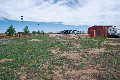
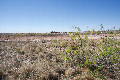
33°N 97°W 3.2 miles (5.1 km) S of Lewisville, Denton, TX, USA [19-Apr-24] |

|
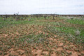
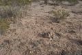
33°N 98°W 2.8 miles (4.5 km) NNE of Whitt, Parker, TX, USA [08-Apr-24] |
|
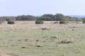
33°N 101°W 11.2 miles (18.0 km) NE of Fluvanna (Scurry), Kent, TX, USA [08-Apr-24] |
|
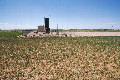
32°N 102°W 4.6 miles (7.4 km) E of Midland, Midland, TX, USA [08-Apr-24] |
|
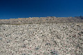
32°N 103°W 11.2 miles (18.0 km) NNE of Kermit, Winkler, TX, USA [08-Apr-24] |
|
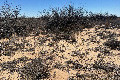
32°N 104°W 8.7 miles (14.1 km) NE of Red Bluff, Reeves, TX, USA [08-Apr-24] |
|
32°N 105°W 12.5 miles (20.2 km) ENE of Dell City, Hudspeth, TX, USA [08-Apr-24] |
|
32°N 104°W 8.7 miles (14.1 km) NE of Red Bluff, Reeves, TX, USA [24-Dec-09] |
|
32°N 98°W 2.3 miles (3.7 km) NE of Hico, Hamilton, TX, USA [incomplete] [24-Mar-06] |

|
33°N 97°W 3.2 miles (5.1 km) S of Lewisville, Denton, TX, USA [22-Mar-06] |
Region Notes:
The Texas Department of Transportation has their Texas Official Travel Map available for download as a PDF file. The map includes latitude/longitude grid tic marks that have been placed at the Degree Confluences. Information on the map projections used in Texas can be found at the TNRIS website.