|

United Kingdom : England
1.1 km (0.7 miles) W of Buckingham, Buckinghamshire, England, United Kingdom
Approx. altitude: 84 m
(275 ft)
([?] maps: Google MapQuest OpenStreetMap ConfluenceNavigator)
Antipode: 52°S 179°E
Accuracy: 5 m (16 ft)
Quality: good
Click on any of the images for the full-sized picture.


| 52°N 1°W (visit #3) |
![Visit #34: [26-Jun-22]](/uk/en/n52w001v34/preview.jpg "Visit #34: [26-Jun-22]")
![Visit #35: [04-Sep-19]](/uk/en/n52w001v35/preview.jpg "Visit #35: [04-Sep-19]")
![Visit #33: [22-Dec-15]](/uk/en/n52w001v33/preview.jpg "Visit #33: [22-Dec-15]")
![Visit #32: [28-Jun-15]](/uk/en/n52w001v32/preview.jpg "Visit #32: [28-Jun-15]")
![Visit #31: [20-Jan-14]](/uk/en/n52w001v31/preview.jpg "Visit #31: [20-Jan-14]")
![Visit #30: [05-Mar-13]](/uk/en/n52w001v30/preview.jpg "Visit #30: [05-Mar-13]")
![Visit #29: [01-Feb-12]](/uk/en/n52w001v29/preview.jpg "Visit #29: [01-Feb-12]")
![Visit #28: [06-Jul-11]](/uk/en/n52w001v28/preview.jpg "Visit #28: [06-Jul-11]")
![Visit #27: [11-Sep-10]](/uk/en/n52w001v27/preview.jpg "Visit #27: [11-Sep-10]")
![Visit #26: [30-Jul-10]](/uk/en/n52w001v26/preview.jpg "Visit #26: [30-Jul-10]")
![Visit #25: [16-Jul-10]](/uk/en/n52w001v25/preview.jpg "Visit #25: [16-Jul-10]")
![Visit #24: [31-Dec-09]](/uk/en/n52w001v24/preview.jpg "Visit #24: [31-Dec-09]")
![Visit #23: [09-Sep-09]](/uk/en/n52w001v23/preview.jpg "Visit #23: [09-Sep-09]")
![Visit #22: [06-May-09]](/uk/en/n52w001v22/preview.jpg "Visit #22: [06-May-09]")
![Visit #21: [27-Mar-09]](/uk/en/n52w001v21/preview.jpg "Visit #21: [27-Mar-09]")
![Visit #20: [31-Dec-08]](/uk/en/n52w001v20/preview.jpg "Visit #20: [31-Dec-08]")
![Visit #19: [27-Jun-08]](/uk/en/n52w001v19/preview.jpg "Visit #19: [27-Jun-08]")
![Visit #18: [03-Apr-08]](/uk/en/n52w001v18/preview.jpg "Visit #18: [03-Apr-08]")
![Visit #17: [03-Apr-08]](/uk/en/n52w001v17/preview.jpg "Visit #17: [03-Apr-08]")
![Visit #16: [16-May-06]](/uk/en/n52w001v16/preview.jpg "Visit #16: [16-May-06]")
![Visit #15: [16-May-06]](/uk/en/n52w001v15/preview.jpg "Visit #15: [16-May-06]")
![Visit #14: [06-Apr-05]](/uk/en/n52w001v14/preview.jpg "Visit #14: [06-Apr-05]")
![Visit #13: [13-Feb-05]](/uk/en/n52w001v13/preview.jpg "Visit #13: [13-Feb-05]")
![Visit #12: [18-Dec-04]](/uk/en/n52w001v12/preview.jpg "Visit #12: [18-Dec-04]")
![Visit #11: [16-Oct-04]](/uk/en/n52w001v11/preview.jpg "Visit #11: [16-Oct-04]")
![Visit #10: [26-Sep-04]](/uk/en/n52w001v10/preview.jpg "Visit #10: [26-Sep-04]")
![Visit #9: [26-Jul-04]](/uk/en/n52w001v9/preview.jpg "Visit #9: [26-Jul-04]")
![Visit #7: [14-Jun-04]](/uk/en/n52w001v7/preview.jpg "Visit #7: [14-Jun-04]")
![Visit #8: [14-Jun-04]](/uk/en/n52w001v8/preview.jpg "Visit #8: [14-Jun-04]")
![Visit #6: [29-May-04]](/uk/en/n52w001v6/preview.jpg "Visit #6: [29-May-04]")
![Visit #5: [01-Nov-03]](/uk/en/n52w001v5/preview.jpg "Visit #5: [01-Nov-03]")
![Visit #4: [16-Oct-03]](/uk/en/n52w001v4/preview.jpg "Visit #4: [16-Oct-03]")
![Visit #2: [13-Nov-01]](/uk/en/n52w001v2/preview.jpg "Visit #2: [13-Nov-01]")
![Visit #1: [27-Dec-00]](/uk/en/n52w001/preview.jpg "Visit #1: [27-Dec-00]")
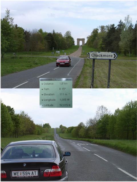
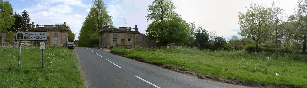
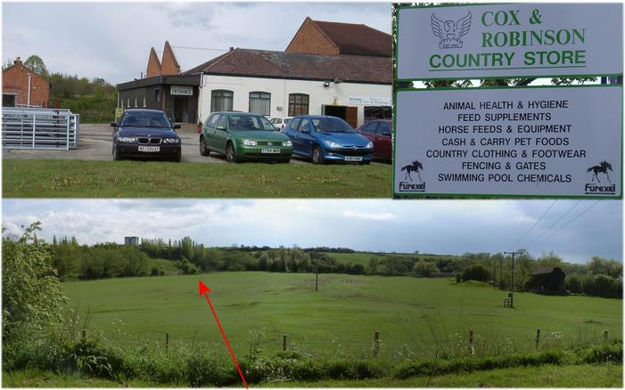
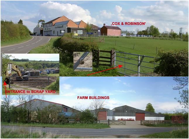
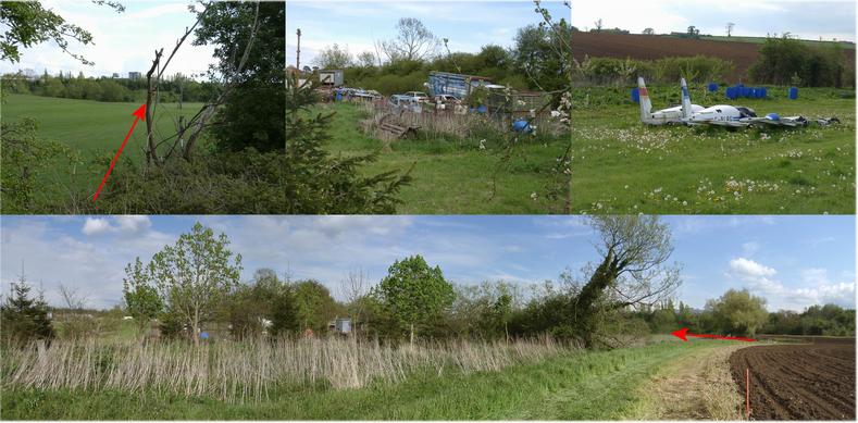
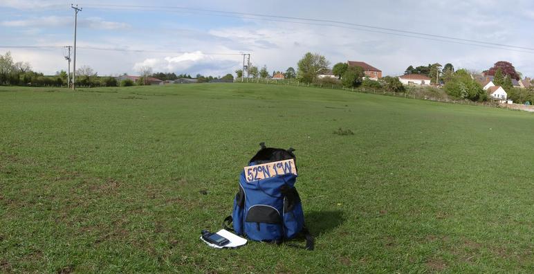
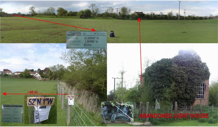
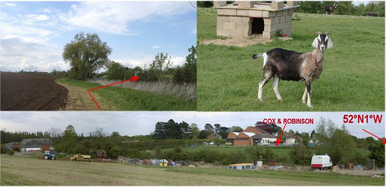
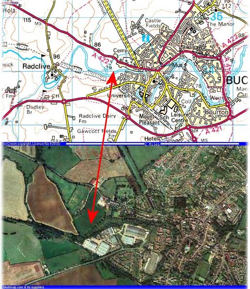
 with plate - view to NORTH") (visited by Hans Augdoppler) 03-May-2002 -- This CP lies directly at the outskirts of Buckingham. Due to road construction work at the A43 I went astray in the direction of the well known Silverstone Motor Racing Circuit. By chance I went past the Historic Stowe Garden, I saw the 'Corinthian Arch' at the northern end of the Stowe Avenue or also Grand Avenue first. I reached the town by 'The Barracks' (picture). As I entered the parking lot of the agricultural store house 'COX & Robinson' the CP itself could be observed very well in the pasture below. The invitation to jump directly over the fence was put off by a brand new looking and with barbed wire reinforced fence. An open gate could be seen on the back, right end, an access via a scrap yard like area was required to it, though. I asked the owner of the store about responsible persons for the meadow and the scrap yard. The answers were only 'I don’t know'. The only result was that the house on the right edge was a former light house. The main gate of the pasture was secured well and also the opposite farm buildings looked well blocked. The whole looked like an industrial farming business, I therefore quitted finding a responsible person (it was weekend). I parked in front of the gate to the scrap yard and started my hike. An opening next to the gate permitted an easy entrance. On this area you can find a great variety of scrap metal, but no human being and no dogs, fortunately. I had to jump a little brook to reach the meadow directly by the open gate. The GPS reception was terrific and it was easy to find the point. It lies in the sheep pasture about 30 m NW from the fence along the creek . On my way back across the scrap yard to the car I met the chief, but he was very peaceful. I am surprised that someone can/may disfigure this neat English landscape in such a manner. Map & aerial photo in pic#8 was provided by http://www.multimap.com For more information see: http://linz.orf.at/gast/augdoppl/Confluence/Main.htm |
| All pictures |
| #1: Confluence marked (temporarily) with plate - view to NORTH #2: Entrance to Stowe Garden & the Stowe Avenue #3: ‘The barracks’ at the NW entrance of Buckingham #4: ‘Cox & Robinson’ country store & view to CP to SOUTH #5: ‘Cox & Robinson’ with eentrance to pasture & farm buildings #6: Route to CP passing the scrap yard & entrance from the NW corner #7: Panorama from WEST to NORTH with fence & light house #8: Map & aerial photo #9: Way back with billy goat #10: View from NW, another access path ALL: All pictures on one page |