|

France : Auvergne-Rhône-Alpes
1.9 km (1.2 miles) S of Tanavelle, Cantal, Auvergne-Rhône-Alpes, France
Approx. altitude: 1014 m
(3326 ft)
([?] maps: Google MapQuest OpenStreetMap ConfluenceNavigator)
Antipode: 45°S 177°W
Accuracy: 3 m (9 ft)
Quality: good
Click on any of the images for the full-sized picture.


 not far away from the confluence point")

| 45°N 3°E (visit #1) |
![Visit #9: [25-Apr-23]](/fr/all/n45e003v9/preview.jpg "Visit #9: [25-Apr-23]")
![Visit #8: [30-Dec-21]](/fr/all/n45e003v8/preview.jpg "Visit #8: [30-Dec-21]")
![Visit #7: [30-Nov-14]](/fr/all/n45e003v7/preview.jpg "Visit #7: [30-Nov-14]")
![Visit #6: [01-Sep-13]](/fr/all/n45e003v6/preview.jpg "Visit #6: [01-Sep-13]")
![Visit #4: [28-Oct-05]](/fr/all/n45e003v4/preview.jpg "Visit #4: [28-Oct-05]")
![Visit #3: [24-Jun-05]](/fr/all/n45e003v3/preview.jpg "Visit #3: [24-Jun-05]")
![Visit #5: [31-Mar-05]](/fr/all/n45e003v5/preview.jpg "Visit #5: [31-Mar-05]")

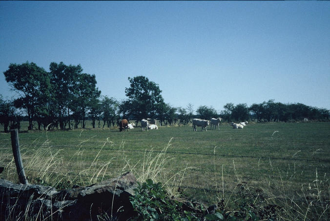
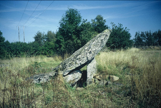
(visited by Barbara Loebau) 06-Aug-2001 -- To our second confluence point (the first was 46°N 3°E) on our three weeks cycling tour through Auvergne and Cevenns we started from the camping site in Murat up to the ‘Col de Prat de Bouc’ and a hike to the ‘Plomb du Cantal’, the highest mountain in this area (1855 m.) You can see this mountain even from the confluence point. In the afternoon we had plenty of time to ride down the road D44 to Paulhac and a small village called Courtines. Just behind this village we turned left on a small road (without any sign where it leads to) in the direction of les Termes. We switched on our GPS pointing to the right hand side into a wide meadowland... We stopped at a meadow with some bulls in it. We had to climb over the fence - the bulls watching us sceptically but they seemed to be very peaceful. Only some hundred meters left to the confluence point - just a point in the middle of the meadow, nothing special, but a great wide view of the surroundings. Looking to the east you can see the village Langlade. If you have some time left, you can visit the ‘Grand Dolmen de la Table au Loup’ (at 44° 59.225' N 3° 0.594' E, altitude 1018 m) not far away from the confluence point. |
| All pictures |
| #1: view to the west with the Cantal mountains in the background #2: view to the north: in the background the village Tanavelle, beautifully located on a hill #3: myself, at the confluence point, in the background the village Langlade #4: ‘Grand Dolmen de la Table au Loup’ (at 44° 59.225' N 3° 0.594' E, altitude 1018 m) not far away from the confluence point #5: the "owners" of the confluence point ... bulls that live near and at the confluence point. ALL: All pictures on one page |