|

United States : Kentucky
5.0 miles (8.0 km) SW of Mt. Sterling, Montgomery, KY, USA
Approx. altitude: 303 m
(994 ft)
([?] maps: Google MapQuest OpenStreetMap topo aerial ConfluenceNavigator)
Antipode: 38°S 96°E
Quality: good
Click on any of the images for the full-sized picture.


| 38°N 84°W (visit #2) |
![Visit #3: [31-Oct-17]](/us/ky/n38w084v3/preview.jpg "Visit #3: [31-Oct-17]")
![Visit #1: [24-Apr-01]](/us/ky/n38w084/preview.jpg "Visit #1: [24-Apr-01]")

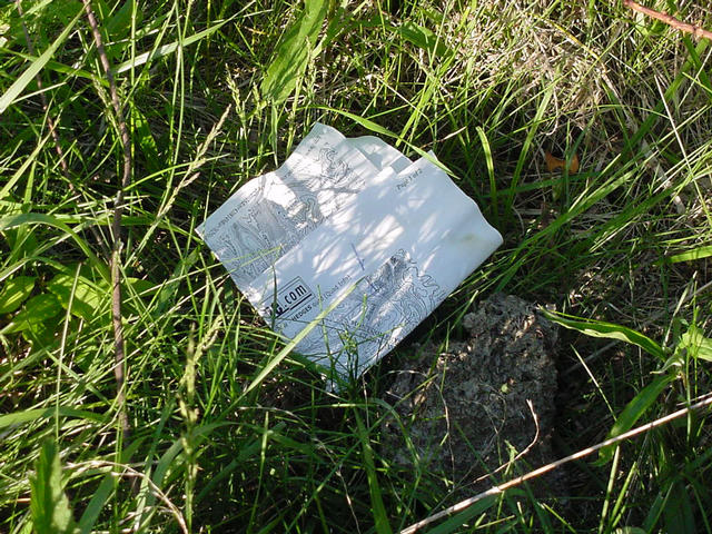
(visited by Paul Stackhouse and Christa Stackhouse) 28-Apr-2001 -- When a friend mentioned the Confluence Project, I was immediately intrigued. When I learned that I lived less than an hour from one, I became obsessive. I planned, printed maps, visited the library, borrowed a GPS, visited bookstores and even bought a new compass. The day arrived. April 28, 2001. My six-year-old daughter had agreed to accompany me on my quest. Her soccer game ended about 3:00; and we set out soon thereafter. The weather was great for late April, and Interstate 64 headed east from Lexington was surprisingly light for a Saturday afternoon. We followed the maps, looking for an unlabeled gravel road that would take us to the closest point without having to cross water. A sign beside the road was marked no trespassing; but obviously a number of homes were on the road; we ventured forward to find someone to ask permission from. The young man whose father owned the farm was very helpful, especially after I gave him the letter, but suggested a nearby farm could offer better access. We drove a mile to the east, but were unable to locate anyone at the other farm. We attempted a southern route, and located the brother-in-law of the absent owner who suggested a letter to gain permission. From his driveway we could see where the confluence must be; just beyond a ravine. We went back to the original youth who had been so friendly, and he agreed to let us hike through to the back of their property; suggesting that his father would be at the barn as we drove by and that we should speak with him. The farmer saw us from his tractor, and jumped down before I could even open the car door. He was intrigued by our quest, and suggested that we could drive most of the way, over his fields to a tall knoll at the corner of his property to gain close access for photos. This confluence is more than just latitude and longitude. Three different properties and three branches of a creek all meet within a hundred feet of our mark. We parked atop the hillock and walked down a steep slope, over a short fence (with no signs) stepped over a narrow creek and back up another hill. Deer paths and tracks were everywhere. As we approached the confluence a large tree became visible that I recognized from the aerial photos. But where was the second tree? As we topped the hill, the fallen tree became visible. (Photo #1) The confluence was exactly where the maps said it should be. As I snapped the photos, I noticed a piece of paper on the ground. We were not the first visitors to this confluence - an ink-jet printed page from a contour map was folded carefully under a cow pile with an arrow drawn to the confluence. (Photo #5) I don't know who the visitors were, but took a photo of their souvenir. |
| All pictures |
| #1: Photo of confluence #2: Christa standing at confluence in front of fallen tree, facing NE #3: Facing West #4: The overweight hiker #5: Previous visitor's map #6: GPS Photo ALL: All pictures on one page |
| Notes |
|
This confluence is located on private property. We have received a note from the property owner indicating that he is not interested in future visits. Because of this, we will not be accepting any visits to this confluence without proof of legal access. Remember, if a confluence is on posted land, obtain permission and don't trespass! |