|

France : Grand Est
5.3 km (3.3 miles) WSW of Metzeral, Haut-Rhin, Grand Est, France
Approx. altitude: 747 m
(2450 ft)
([?] maps: Google MapQuest OpenStreetMap ConfluenceNavigator)
Antipode: 48°S 173°W
Accuracy: 11 m (36 ft)
Quality: good
Click on any of the images for the full-sized picture.


")


| 48°N 7°E (visit #1) |
![Visit #8: [14-Oct-17]](/fr/all/n48e007v8/preview.jpg "Visit #8: [14-Oct-17]")
![Visit #7: [04-Aug-16]](/fr/all/n48e007v7/preview.jpg "Visit #7: [04-Aug-16]")
![Visit #6: [31-Jul-11]](/fr/all/n48e007v6/preview.jpg "Visit #6: [31-Jul-11]")
![Visit #5: [11-May-08]](/fr/all/n48e007v5/preview.jpg "Visit #5: [11-May-08]")
![Visit #4: [31-Dec-04]](/fr/all/n48e007v4/preview.jpg "Visit #4: [31-Dec-04]")
![Visit #3: [20-Oct-04]](/fr/all/n48e007v3/preview.jpg "Visit #3: [20-Oct-04]")
![Visit #2: [12-Sep-03]](/fr/all/n48e007v2/preview.jpg "Visit #2: [12-Sep-03]")

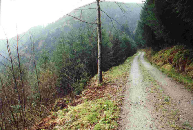
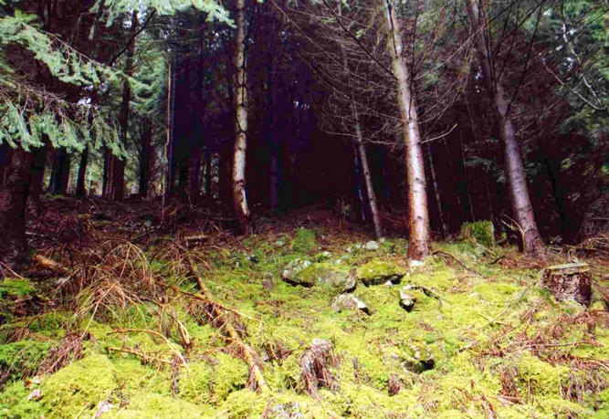
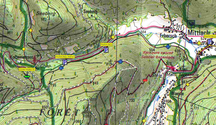
(visited by Yorck Schneider-Kühnle and Sabine Kaus) 08-Apr-2001 -- After our first confluence point turned out to be already visited a couple of days ago our next weekend took us to Colmar/France. From there it was about another 30 km to the confluence point. The drive from Colmar via Munster to Mittlach turned out to be really beautiful as the trees were blooming and so were the daffodils. Arriving in Mittlach we came into the last preparations of the annual daffodil celebration where tons of yellow daffodils where decorated all over the village. We drove out of the village and parked the car. The GPS indicated the confluence point to be about 1.5 km away. The valley was really beautiful but the weather rather cold and rainy. The stream just next to the road was crystal clear but pretty noisy as well. At first the satellite reception in the valley was really poor. I lost satellite lock several times and was afraid to not even get a lock at the point. But the situation improved later on as the valley got wider and the satellite constellation improved. We hiked a bit and found some really nice paths and spots. The closing in to the point took us quite some time as we mislocated the spot on the map at first. The confluence point turned out to be deep in the woods with (about) no chance to go there (maybe creeping would help) and especially no useful pictures to take (dark trees surrounded by dark trees isn't really picturable). The best impression you can get from the path about 80 m below (+/- 9 m from the GPS) the point (white on the map) as you can look down the valley quite a bit (pictures 1, 2, 3). I tried to come even closer to the point in climbing up the hill over some rocks covered with moss but got stuck about 50m below the point with no reliable position from the GPS due to thick tree coverage (picture 4). Nevertheless the upper track (brown-red on the map) took us up to about 10m to the point with an given GPS accuracy of 10m (picture 6) what is well within the 100m accuracy of the project. The picture from the upper track about 10 m away from the confluence point only show the track downhill looking back to the road we came on (picture 5). For future visitors to the spot I listed the data of the three waypoints in the Map below. If anybody should be interested in the track data I collected on the trip you can contact me by mail. But still the best source I found for this area is the topographical map 1:25000 from IGN and "Le Club Vogesien" (Serie Top25, No. 3618 OT) from where I scanned a small part. The road is paved just up to about 150m to the spot although I am not sure, if cars are really allowed up there but the walk from the indicated parkings isn't too far either and really beautiful. The last meters (on both tracks above and below the point) are unpaved forest roads that can be easily hiked.
Table of waypoints in the map:
|
|||||||||||||||||||||||||
| All pictures | |||||||||||||||||||||||||
| #1: upper track about 10m above the point, view down to the road #2: track 80 m below the point, view south, further up the track #3: Sabine in front of the confluence point #4: the confluence point is about 50m ahead in the black part of the picture #5: track 80 m below the point, view north (towards the road) #6: the proof.... at the closest spot available. #7: Map ALL: All pictures on one page |