|

Saudi Arabia : al-Riyād
83.8 km (52.0 miles) SW of Al Khala'iq al Gharbiyah, al-Riyād, Saudi Arabia
Approx. altitude: 944 m
(3097 ft)
([?] maps: Google MapQuest OpenStreetMap ConfluenceNavigator)
Antipode: 24°S 135°W
Accuracy: 130 m (426 ft)
Quality: good
Click on any of the images for the full-sized picture.


| 24°N 45°E (visit #1) | (incomplete) |
![Visit #2: [14-Nov-02]](/sa/all/n24e045v2/preview.jpg "Visit #2: [14-Nov-02]")

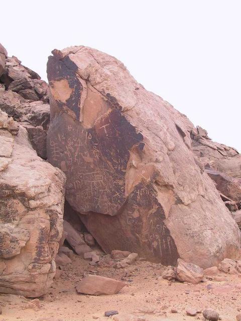
(visited by Gerhard Henrich, Trudi Fritz, Helmut Salner, Renate Schlipkoether, Norbert Schlipkoether, Edith Gosewinkel, Udo Gosewinkel, Anni Langenfeld, Erich Langenfeld, Elisabeth Henrich and Edith Angermeir) 01-Mar-2002 -- Today we saw our chance in going westwards to the 24N 45E. Although the weather was not very promising in the morning, we set off in good hope for an improvement. Lucky we were, because we learned after return that there was a rainy day in Riyāḍ, but for us, the further we went west, the more sunshine we gained. So, out of Riyāḍ, westwards down the well known escarpment and in the direction of Makka and Jidda, that is one of the most busiest highways in Saudi Arabia. I calculated that the trip would take a bit more than two hours until we would be in the vicinity of the Confluence. But we had a guest from Germany on board and some of our group hadn't yet visited a famous landmark right on our way, which is called the Grafitti Rock. That rock is a monolith in a plane of sand and covered all over with ancient grafittis, but unfortunately modern stone-age people engraved their visits as well. Further on we headed via al-Quway`iyya, and some 30 kilometres after that town we left the highway into the mountains. We had some objections for reaching this Confluence, because the more we drove into the valleys, the higher the mountains appeared. That area is very beautiful, because surrounded by sandstone hills, huge granite mountains rise up to the horizon. After some failed attempts because we hit the wrong wādīs (valleys), we finally found the right track to the Confluence after zig-zagging over sharp rocks, which was not to the benefit of the tires. Some 380 meters before the Confluence there was a real end for our cars and the final approach had to be done by walking. Walking? That was a trip like mountain goats in the Himalaya. But the confluence point was hit and one can see the result on the GPS reading. (Co-ordinator's note: The GPS reading, being clearly designated as the result of "hitting" the confluence point, rather indicates a remaining distance of 130 m from the 24N 45E confluence. The visit has therefore been classified as "attempted".) Back to the cars we looked for a nice picnic ground and we found one in a nice valley beside our track. That place was so beautiful, that we decided to come back at another date in order to spent a whole weekend between those majestic mountains. Finally we came to the conclusion that this day was a very successful day by all means. |
| All pictures |
| #1: End of track towards the Confluence #2: View to the east and on Elisabeth #3: GPS reading #4: Group at the Confluence #5: Traditional farm in the valley #6: Rock formations #7: Graffiti Rock ALL: All pictures on one page |