|

United Arab Emirates
7.0 km (4.3 miles) E of Filiy, Ra's al-Khayma, UAE
Approx. altitude: 294 m
(964 ft)
([?] maps: Google MapQuest OpenStreetMap ConfluenceNavigator)
Antipode: 25°S 124°W
Quality: good
Click on any of the images for the full-sized picture.


")


| 25°N 56°E (visit #1) |
![Visit #9: [14-Jan-13]](/ua/all/n25e056v9/preview.jpg "Visit #9: [14-Jan-13]")
![Visit #8: [19-Aug-11]](/ua/all/n25e056v8/preview.jpg "Visit #8: [19-Aug-11]")
![Visit #6: [07-Feb-09]](/ua/all/n25e056v6/preview.jpg "Visit #6: [07-Feb-09]")
![Visit #2: [08-Oct-06]](/ua/all/n25e056v2/preview.jpg "Visit #2: [08-Oct-06]")
![Visit #7: [29-Apr-11]](/ua/all/n25e056v7/preview.jpg "Visit #7: [29-Apr-11]")
![Visit #5: [10-Jan-08]](/ua/all/n25e056v5/preview.jpg "Visit #5: [10-Jan-08]")
![Visit #4: [30-Nov-07]](/ua/all/n25e056v4/preview.jpg "Visit #4: [30-Nov-07]")

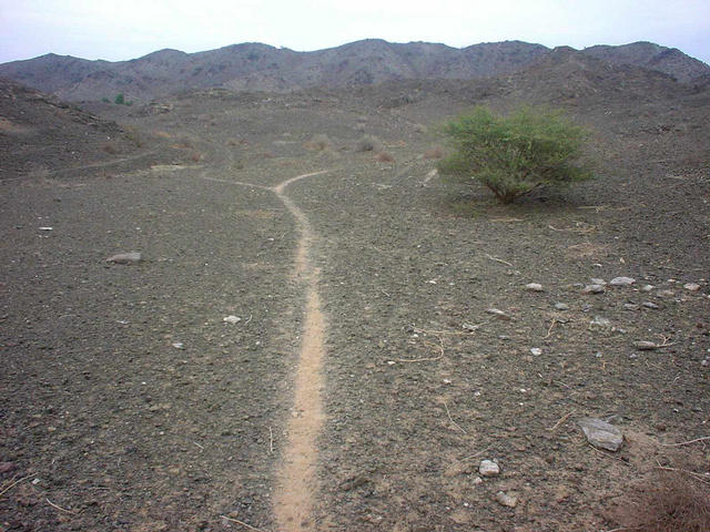
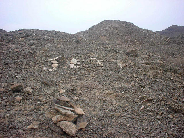
(visited by Stefan Beck, Alex Beck and Martina Beck) 29-Nov-2001 -- Our family, Alex (one year old) and parents Stefan and Martina headed out from Dubayy to visit the confluence 25N 56E. The weather was very nice with temperatures around 25°C and partly cloudy. This was an unvisited spot according to confluence.org, and we were in very high hopes to be the first ever on the spot, because it is really in the 'middle of nowhere'. This is already our second attempt. The first one failed due to the sunset. We could not risk staying in the unknown wilderness in darkness. We came from the south through Oman, and came close up to 1.2 km. We found a very nice area for offroading. Anyway here we are on our second attempt: We drove the highway towards Ḥattā, and turned in Madām to al-Ḍayd and later to Filiy, the road was easy and we reached the small village of Filiy after 55 minutes from home. We visited two old watch towers there and met a friendly local man who showed us his gardens and goats, which Alex loved. Filiy lays in the gravel plains outside the mountains with considerable (for the area!) farming of date palms and vegetables. We continued East until the paved road ended and a gravel track began. Then we reached the dam at Wādiy Burāq, crossed it, and negotiated along the wādiy bed (= dry valley), which was good and also had lots of wheel tracks from previous cars. The area turned very hilly, with rocky ridges. Eventually we had to stop the car and were forced to walk for about 350 meters. We had a lovely walk on an old animal track. We easily reached the confluence spot, and were disappointed, because it seemed that someone was already there and marked it with stones and put his initials or name there, called: JETT, so we have to say: Jett, who ever it is - was there before us. See the picture. Anyway, these things happen probably more often, and who knows, perhaps Jett is busy putting landmarks everywhere. So at least we are busy following Jett's footprints and confluence marks. We will head out soon to visit more Confluences and will not be surprised to find Jett's marks again... let's see. The Confluence is on a slope in a very dry and barren area in the foothills of the Ḥajar mountains. The vicinity is mostly stony and rocky with only very few low bushes. See the pictures. The Ḥajar mountains are in the east of the United Arab Emirates stretching for many hundred kilometers into Oman. Due to the height of the mountains there is rain at times, especially in winter. But nevertheless it was a great nice afternoon trip in a lovely area, enjoyable for everyone in this time of the year. We are sure to explore this area more intensely in the next future, of course beside searching for new JETT confluence marks. See you, Coordinator's Note: In July 2007 the DCP received the following message, posted by Andrew Foley: Hi, I'm Jett. It was my Dad who marked the Confluence with my name in white stone. At first we didn't know why he was looking for the spot where he did this. He was driving around looking at his GPS. I will find the pictures we took that day and post them on this site. I'm a girl and I was born in Dubai in 1998 but now live in Australia. The mystery about 'Who is Jett?' was fun. Thus one 'confluence mystery' finally got solved after nearly six years. Unfortunately, the promised photos never got posted. |
| All pictures |
| #1: From the Confluence to the North #2: The proof on the GPS #3: Animal track and bush nearby the Confluence #4: From the Confluence to the East (South and West are pretty much the same) #5: The spot of the Confluence with JETTs signs #6: Alex and Stefan at THE SPOT #7: Martina and Alex ALL: All pictures on one page |
| Notes |
|
The borderline with Oman is passing about 400 m south of the Confluence. |