|

Switzerland
near Gandria, Ticino, Switzerland
Approx. altitude: 271 m
(889 ft)
([?] maps: Google MapQuest OpenStreetMap ConfluenceNavigator)
Antipode: 46°S 171°W
Quality: good
Click on any of the images for the full-sized picture.


| 46°N 9°E (visit #3) |
![Visit #10: [06-Aug-24]](/ch/all/n46e009v10/preview.jpg "Visit #10: [06-Aug-24]")
![Visit #9: [14-Jul-17]](/ch/all/n46e009v9/preview.jpg "Visit #9: [14-Jul-17]")
![Visit #8: [29-Oct-15]](/ch/all/n46e009v8/preview.jpg "Visit #8: [29-Oct-15]")
![Visit #7: [22-Nov-08]](/ch/all/n46e009v7/preview.jpg "Visit #7: [22-Nov-08]")
![Visit #6: [19-Jul-07]](/ch/all/n46e009v6/preview.jpg "Visit #6: [19-Jul-07]")
![Visit #5: [14-Aug-05]](/ch/all/n46e009v5/preview.jpg "Visit #5: [14-Aug-05]")
![Visit #4: [29-Apr-01]](/ch/all/n46e009v4/preview.jpg "Visit #4: [29-Apr-01]")
![Visit #2: [29-Dec-00]](/ch/all/n46e009v2/preview.jpg "Visit #2: [29-Dec-00]")
![Visit #1: [12-Oct-99]](/ch/all/n46e009/preview.jpg "Visit #1: [12-Oct-99]")

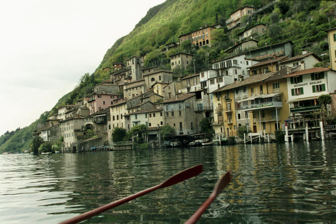
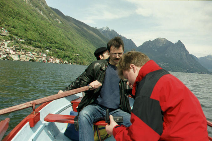
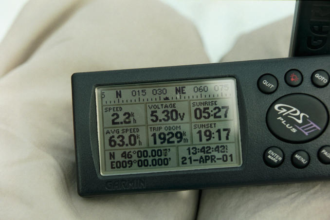
(visited by Werner Furlan, Jörg Kerschbaumer, Günter Lenz and Uwe Kroiss) 21-Apr-2001 -- We were on a trip to Italy and I thought, it would be a good idea to have a break in Lugano. I had already printed exact maps for this purpose, and the question was if we could get a boat to reach the confluence in the middle of the lake of Lugano. The closest village to the confluence is Gandria. It is a really nice place, also worth a visit if there had not been a confluence. The village is situated on a steep slope going down to the lake and there are only stairs and footpaths in this village. So we parked our car above the village and went down to the bank of the lake. We saw a man in a rowing boat coming towards us, we asked him if we could rent his boat for a short trip, but he denied, the boat was too small for 4 persons, but he gave us a hint that helped us further... After his advice we went to Hotel Moosmann, and the landlord was willing to give us his rowing boat to take some pictures. We had a very good meal in his restaurant, and after dinner we mounted our boat and rowed in direction to the confluence. It was quite windy and the point was difficult to find, because of the wind we always were driven off course. But finally we made the point! The picture from the GPS was not exactly on the point, but close enough to be valid. 21-Apr-2001 -- Durante un viaggio in Italia decidemmo di fermarci per una breve sosta a Lugano. Avevo già preparato delle mappe per questo scopo ed adesso ci mancò solo una barca per raggiungere il punto d'intersezione, trovandosi proprio nel centro del Lago di Lugano. Il villaggio più vicino del punto è Gandria, un posto proprio bellissimo e sarebbe anche suggeribile di visitarlo se non ci fosse un punto d'intersezione. Il villaggio si trova su un pendio ripido verso il lago e ci sono solo scale e sentieri. Perciò posteggiammo la machina al di sopra del villaggio e scendemmo verso la riva del lago. Vedemmo un uomo in una barca a remi manovrando verso noi. Chiedemmo di noleggiarla per una breve gita me rifiutò poiché la barca era troppo piccola per quattro persone. Ma ci diede un suggerimento che ci aiutava ... Dopo quel suggerimento andammo dal Hotel Moosmann ed il padrone ci diede la sua barca per fare qualche foto. Avemmo un ottima cena nel suo ristorante e dopo cena preparammo la barca e procedemmo in direzione del punto. Era una giornata assai ventosa ed è stato difficile di centrare il punto poiché il vento ci spinse sempre fuori rotta. Ma finalmente facemmo il punto! La foto del GPS non è stata fatta esattamente sul punto, ma abbastantza vicina per essere valida. |
| All pictures |
| #1: Looking north - Guardando verso Nord #2: Looking south - Guardando verso Sud #3: Looking east - Guardando verso Est #4: Looking west - Guardando verso Ovest #5: Gandria from the lake - Gandria vista dal lago #6: While navigating to the confluence in our rowing boat - In navigazione con l'imbarcazione verso il punto #7: GPS reading at the confluence - Lettura dello schermetto GPS al punto d'intersezione ALL: All pictures on one page |
| Notes |
|
In the Lago di Lugano. |