|

Saudi Arabia : al-Šarqiyya
17.9 km (11.1 miles) SE of Ġunān, al-Šarqiyya, Saudi Arabia
Approx. altitude: 0 m
(0 ft)
([?] maps: Google MapQuest OpenStreetMap ConfluenceNavigator)
Antipode: 26°S 130°W
Quality: better pictures needed
Click on any of the images for the full-sized picture.


| 26°N 50°E (visit #1) |
![Visit #3: [11-Sep-08]](/sa/all/n26e050v3/preview.jpg "Visit #3: [11-Sep-08]")
![Visit #2: [12-Oct-07]](/sa/all/n26e050v2/preview.jpg "Visit #2: [12-Oct-07]")

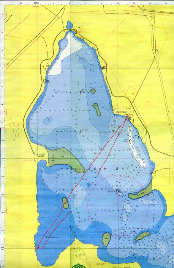
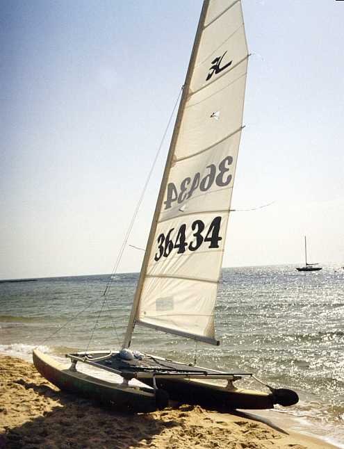
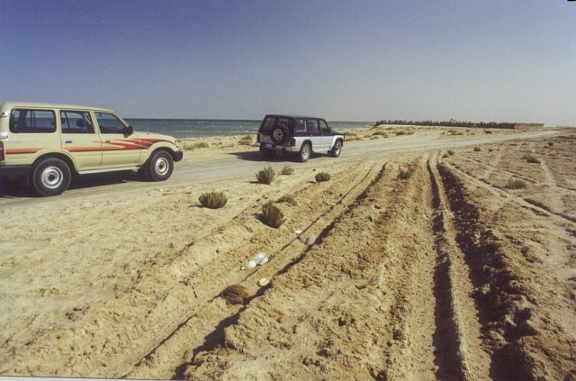
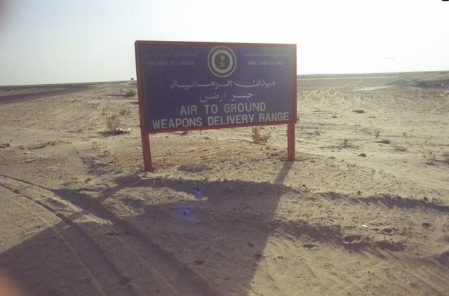
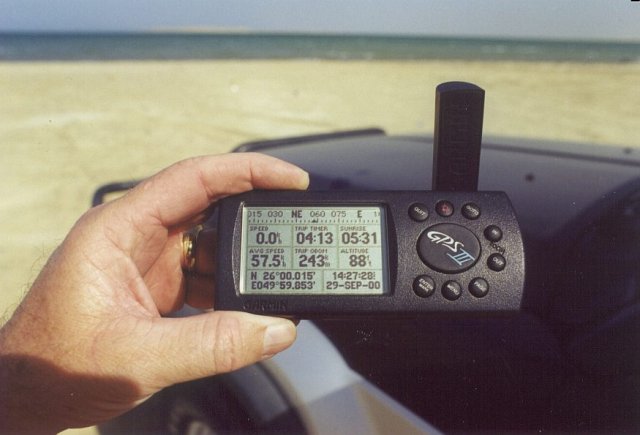
(visited by Colin Irvine and Ken Long) 29-Sep-2000 -- The Confluence 26N 50E lies about 50 meters off the southwest shore of Half Moon Bay near al-Ẓahrān, Saudi Arabia (see map). The entire Arabian Peninsula is tilted up from East to West. The Western region contains a spectacular escarpment that reaches over 10,000 feet (3000 m) above sea level. The East coast, however, is recently promoted seabed. This makes for incredibly dull photos from sea level. So dull in fact, that after seeing them, I decided I had to make an overland assault after my initial marine approach just to get some photos with identifiable objects in them. My wife will confirm that my procrastinating skills are second to none. The first visit was in March 2000 and the overland approach did not take place until September 2000. Since it is now February 2001, I think I will post what I have to the site before the photos begin to fade. The company I work for maintains a beach facility on the bay and I keep a small Hobie 14 sailboat there. I decided to take the boat over to the Confluence as I suspected the water would be shallow enough to stand in at the spot. The bay is a little jewel. It opens onto the Arabian Gulf through a relatively narrow opening to the southeast. The water is absolutely pristine. Around this time of year, the dolphins come back with babies. They love sailboats and I am occasionally escorted by a group of several swimming along side so close that I can hear them breathing and squeaking to each other. The day I went to the Confluence, we were having a Šamāl, a strong wind from the north. The wind speed was about 15-20 mph (25-30 km/h) which is moderate for a Šamāl, it can get to 35+ (> 55 km/h). The water is not freezing, but the Hobie is a very wet ride and I expected to be soaked on the way over. I put the GPS into a waterproof bag and stuffed it into my lifejacket with the antenna just sticking out below my chin. I navigated using a hand bearing compass. There is a rocky spine that projects northwards into the bay from a hill in the South. While the Hobie must draw about 4 inches (10 cm) with the rudders up, I managed to run aground – twice – on this outcrop which is just below the surface east of the Confluence. I knew it was shallow when I saw the legs of the birds which I had supposed were floating on the surface but which were actually standing on the rocks. I managed to shift around on the trampoline enough to drift over the rocks and sail the rest of the way to the Confluence. I manoeuvred directly over the Confluence in about 3 feet (1 m) of crystal clear water and fired up the Nikonos for some pictures. Unfortunately there was a big blob of half-dried sea water on the lens which made pictures lousy on top of being boring. I shot a picture of the GPS snug and dry in its little body bag, but the Nikonos, not being an SLR, allowed me to take a photo so out of focus that the Garmin looked like a big blue Popsicle. I had brought a waterproof dinghy suit with me and I climbed into it for the trip back. That was not a mistake. The Šamāl had come up and the return journey was quite lively and very, very wet. The photo results were shameful, so I decided to approach the Confluence from the beach. OK, so it took me several months. The drive around the bay is also quite interesting. The road only goes about halfway and the rest is over a pretty treacherous salty track across the sabkha. Sabkha is a large, inviting area of perfectly flat sand that looks like a dry lakebed. It appears to be the express lane to wherever you want to go. Unfortunately, there is water just below the surface and once you break through the thin crust, it’s usually goodbye to half a tank of gas and the rest of your day while you try to claw your way back 100 feet (30 m) to solid ground. There is a track across the sabkha, packed down by the passage of many vehicles. God only knows how many of them were sunk in there to form a permanent part of the roadbed. If the track is wet, which happens more from tides than rain, forget about it. Oh yes... Did I mention the bombing range? Well, you do have to skirt this iddy-biddy bombing range to get to the site this way. It was quite active during the Gulf War when they practiced obliterating tanks and armored vehicles there. The whole place is probably very rich in depleted uranium. Just stay near the water and don’t make any turns to the west. We considered it good practice for the Nevada test site Confluence. So, what went wrong on this trip? Well, I forgot the body bag for the Garmin and I only brought the old SLR. I have a photo of the GPS about 200 meters from "the spot" on the beach. I waded out to the Confluence, but left the camera on the beach. We have been through too much together to for me to ask it to take a dunking in this hyper saline water. Photos:
|
| All pictures |
| #1: Marine Confluence - Mission accomplished #2: Marine Confluence Entrapment Vehicle #3: Mission equipment: GPS, camera, survival suit, compass, Snickers bar #4: If detained, I would eat this map which is the size of a place mat at IHOP #5: Overland mission - Second half of Operation Pincer #6: No Wuss shall pass #7: The Confluence is about 200 meters in front of the car. #8: A view of the bay from what is called North Hill on the map. ALL: All pictures on one page |
| Notes |
|
About 150 m from the coast in a bay of the Gulf. |