|


United States : Kansas
3.7 miles (5.9 km) WSW of Caney (Montgomery), Chautauqua, KS, USA
Approx. altitude: 287 m
(941 ft)
([?] maps: Google MapQuest OpenStreetMap topo aerial ConfluenceNavigator)
Antipode: 37°S 84°E
Accuracy: 5 m (16 ft)
Quality: good
Click on any of the images for the full-sized picture.


| 37°N 96°W (visit #4) |
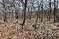
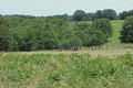
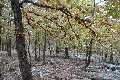
 (visited by Joseph Kerski) 06-Nov-2026 -- As I was in the area promoting and supporting Geospatial Technologies specifically at the College Of The Muscogee Nation, a confluence visit seemed like the perfect ending to a wonderful week full of mapping and studying the Earth. I had been thinking that my Michigan confluence visit from September would be my last visit of the year, so I have been thinking that while I was in Oklahoma, perhaps a side trip to this point might be feasible. Plus it would be nice to be able to get one more visit if it all possible. This would make 18 for the year. But much more importantly, this was a lone solitary point that I have not visited within a vast area of the Midwestern USA… spanning hundreds and hundreds of miles. Over the past 25 years I’ve gotten just about every other point in a multiple state area except for this one —would I be able to visit this today before going to the airport? There was only one way to find out… And so I departed Okmulgee at 7 AM… reaching Caney, Kansas, just before 9:00. The weather had been ominous and threatening, but as I near the Kansas State line, the sky slightly brightened, although the sun had not shown yet. At least it wasn’t raining which it had been on the time a year and a half ago when I visited a point 1° east of here: That was a very wet experience! I stopped in Caney, Kansas at the city park. Once there, I put on my geeky latitude longitude sign, and got out the GPS unit. I was the only one in the park. I then drove through the lovely three block downtown and passed the ballfield, the levee, and the wetland, to the west. To my surprise, the road turned to dirt as I headed up the hill after the valley ended. After about 10 minutes, I reached my destination. I had driven to what I considered to be one of two possible access options.… The first being the building and the driveway to the north north east of the confluence point. I exited the main dirt road and drove slowly toward the building, Only to be stopped a short time later, with a very large gate and two no trespassing signs, and some horned cattle on the gate who came up inquiringly. The no trespassing signs had something about the energy company operating facilities just to the south of here, the building was only a short distance away, but I couldn’t determine if anybody was there… I considered beeping the horn but in the end, decided to heed the signs and make my exit. Fortunately, I had another option for Plan B. This involved driving West on the main East - West Rd. and then south down a driveway and down another driveway, approaching the point from the northwest. All was quiet in the farmsteads. I approached the house to the northwest of the confluence point. I don’t like to drive too close to people’s homes and thereby make them nervous arriving unannounced, so I parked about a half a football field down the driveway. I proceeded on foot which I hope always on these treks is less threatening. At a cattle guard, two dogs came up, one a large white puppy and another one a larger white and caramel colored dog that perhaps was related to a husky or a sheep dog, I’m not sure. No doubt it was the same dog as my colleague found here two years ago. The larger one seemed hesitant to cross the cattleguard, but the younger one came up, but kept a wary distance. I tried to speak in soothing tones. I stood there a while… But it was becoming evident that nobody was home. I pondered my options, but in the end decided to leave a note on my vehicle, explaining my purpose, and then I set off briskly to the south east, skirting around the barn and found a faint track heading east. There were cattle and horses. There was a gate that I could slither underneath, and then I was in until ground heading southeast. I climbed a rise and had a magnificent view off to the north. Behind the rise was a beautiful small pond. There were some very sharp thorns in the field and some tripping hazards so I took care. I already knew that the point was not going to be in the field, but rather in the forest land to the east. I was able to cross into the forest, but before I did so took some pictures of the GPS unit in case I totally lost signal in the trees. I didn’t have a worried, because the trees within enough, although it was a magnificent oak forest, to see the sky and wild the GPS constellations were reduced. I was able to in about 10 minutes I found the point in the trees. A very faint car track lies just to the east of the dividing line between the forest and the field to the West. The confluence lies on somewhat rocky ground in the forest sloping slightly to the southeast. The temperature stood at about 53° under cloudy skies and moderate winds. Aside from the farm animals and some birds, I saw no other animals or people. As always I thought of the Indigenous population that had roamed these valleys and hills for centuries, the 19th century farmers and ranchers, and the people that live on the land today, with great respect for them all. After taking photographs and videos, and my video is on my Our Earth YouTube channel here” , I stepped back out to the west, crossing into the open field again, but this time heading south so I could go to the Oklahoma border, which lay about a football field to the south. There is a very old stone marker there and a tri corner fence. As my colleague noted, this is also a corner of several counties in Kansas and Oklahoma. I do love standing on state and national border lines and I enjoyed the moment, but I didn’t stay more than two minutes. I headed back to the north West passed the pond down the hill and I did so I glanced behind me and sure enough the dogs had followed me into the forest and were behind me now. It had been a good year for visiting confluence points: 18 in all for me. These included points in Kansas, Oklahoma, Arkansas, Louisiana, Texas, Alabama, and Michigan. Each held wonderful memories of reaching them and standing on them. I had stood down 37° north latitude many times, from California on the west to South Carolina or Georgia on the east. I also have stood on 96 west longitude many times, from North Dakota on the north end, to Texas on the south end. Again, this visit was much drier than my very wet visit to the point 1° east of here a year and a half ago but the surroundings looked remarkably similar. I walked back to the north northwest cresting the hill, and having a great view of the farmstead to the northwest. As I suspected, the dogs were not far behind me, ushering me out as I walked around the barn again. My piece of paper was still fluttering at the car. Nobody was home. I then made my exit driving out the way I came in. I drove back to Caney. Afterwards, I drove to the Kansas line on US 75 and got out to walk in the embankment and take a few nerdy pictures and a video of me singing a Kansas song. Then I drove south to Bartlesville and had a very nice walk, my favorite thing… Doing a loop through town. I took a conference call while doing so. Then I drove to the Tulsa airport and it was amazing because there was absolutely no line to check in. Thank you and get out there and explore ! |
| All pictures |
| #1: The confluence point, in the foreground, looking southeast. #2: A view to the north from the confluence point. #3: A view to the east from the confluence point. #4: A view to the south from the confluence point. #5: A view to the West from the confluence point. #6: GPS reading at the confluence point. #7: Ground cover at the confluence point. #8: Joseph Kerski at the confluence point. #9: State line to the south south west of the confluence point. #10: Open view to the north just to the west of the confluence point. #11: One of the gravel roads near the confluence point. #12: State line fence, looking west, so Oklahoma on the left and Kansas on the right. ALL: All pictures on one page |