|
Canada : British Columbia
22.9 km (14.2 miles) NNE of Porter Landing, BC, Canada
Approx. altitude: 1399 m
(4589 ft)
([?] maps: Google MapQuest OpenStreetMap topo topo250 ConfluenceNavigator)
Antipode: 59°S 50°E
Accuracy: 8.8 km (5.4 mi)
Quality: good
Click on any of the images for the full-sized picture.
| 59°N 130°W | (incomplete) |

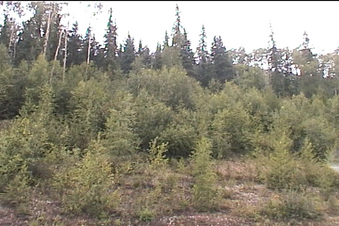
(visited by Dave Patton) During August 2003 I drove through British Columbia and into the Northwest Territories on a combined confluence hunting and sightseeing trip. I started close to 49°N and went as far North as 61°N, covered 6,200 kilometers (3,850 miles), did 7 successful confluence visits, and had another 12 confluences that are incomplete. I made a map that shows the route, and the confluences in the order they were done, with the successful ones shown with black markers. The incomplete visits are a mix of actual attempts and situations where I drove somewhat close to the confluence, and included a 'visit' as a way to document the confluence location for future visitors. The first confluence on the trip was 52°N 121°W. 18-Aug-2003 -- After my incomplete "visit" to 60°N 129°W I continued south on the Stewart-Cassiar Highway (Highway 37). I drove until I reached 59°N, at which point the confluence is 11.6 kilometers to the west. I drove a short way back up the highway, to a pullout next to Pinetree Lake, where I took some video showing the view to the west towards the confluence, and to the east, looking across Pinetree Lake. As you can see, the rainy weather had not stopped. In fact, at times there had been heavy downpours. I continued south on the highway, crossing 130°W (Waypoint 089), where the confluence is 8.76 kilometers to the north. The next confluence on this trip was 57°N 130°W. |
| All pictures |
| #1: west, uphill, towards the confluence #2: east, across Pinetree Lake #3: Landsat-7 satellite image (August, 2001) ALL: All pictures on one page |


