|

United States : Wisconsin
3.6 miles (5.8 km) SE of Boyceville, Dunn, WI, USA
Approx. altitude: 352 m
(1154 ft)
([?] maps: Google MapQuest OpenStreetMap topo aerial ConfluenceNavigator)
Antipode: 45°S 88°E
Accuracy: 9 m (29 ft)
Quality: good
Click on any of the images for the full-sized picture.


.")


| 45°N 92°W (visit #2) |
![Visit #4: [13-Oct-12]](/us/wi/n45w092v4/preview.jpg "Visit #4: [13-Oct-12]")
![Visit #3: [18-May-06]](/us/wi/n45w092v3/preview.jpg "Visit #3: [18-May-06]")
![Visit #1: [28-Jun-98]](/us/wi/n45w092/preview.jpg "Visit #1: [28-Jun-98]")

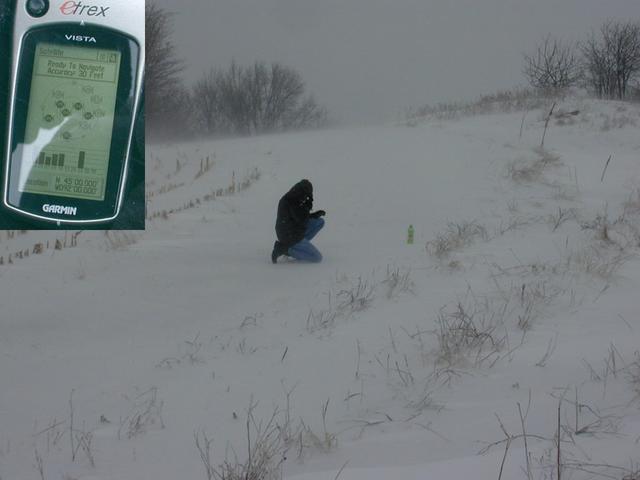
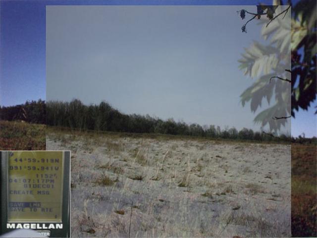
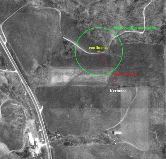
(visited by Dr. Mark W. Palmer and Thomas C.H. Mueller) 09-Mar-2002 -- Our visit to this confluence was prompted by a review of all the visits so far made in the state of Wisconsin. The ladies (Ada and Kate Kerman) who first visited this confluence's territory in 1998 did so without the benefit of GPS; instead relying only on a car's odometer and the Roman soldier's metric of counting paces. Tom and I wanted to see whether the Kermans' confluence claim would stand up to scrutiny. As he has done in the past, the ambitious Mr. Mueller took it upon himself to do some aggressive advance work scouting the area. Not knowing whether I'd have the opportunity to journey there myself in a timely fashion, I gave Tom all the instruments I then had at my disposal for confluence hunting, such that Tom could submit the confluence claim solo should he tire of waiting for me to make the pilgrimage. Tom first made the trip on 1-Dec-2001, but was patient enough to wait through 9-Mar-2002 for me to join him for a subsequent visit with a few new instruments for additional measurements. The day I picked to travel up to the Menominee area was a doozy of a day, quite atypical of March weather even for Wisconsin. The temperatures were falling from early morning onwards, dropping through the twenties during our visit and would reach the single digits after we left. Most notably, a strong low pressure cell was bringing snow on high winds. The average wind speed for the entire day in the area was 20 mph, but the strongest winds were occurring in the early afternoon right when we were working near the confluence: 38 mph max wind speed with a peak gust of 48 mph (National Weather Service, 1:55pm Eau Claire observation). We were thus very fortunate to have been bumped up to a four-wheel drive vehicle rental that morning by the good people at Enterprise Rent-A-Car. We sure made good use of it. As we parked about a quarter-mile distant from the target, our plan was to first get to the confluence and take a few pictures. Tom would then leave me at the confluence and march toward where the Kermans had been. We would keep in touch via 2-way radio and use a Bushnell laser rangefinder as an independent confirmation of what our GPS units were telling us. We set out from our parked vehicle after placing one laminated explanatory letter on the dashboard and one secured under a wiper blade. The incessant push of the west winds propelled us over rolling, snow-encrusted cornfields toward the locations Tom had scouted four months earlier. After some initial ambiguity, Tom recognized the confluence hillside and then used the GPS to zero in on the confluence. I snapped this photo of him crouched on the confluence, verifying that the GPS had indeed settled on the coveted "all zeroes" reading (inset). In this posture, Tom was less likely to be blown off balance by the relentless gale or lose his footing on the ice crust. I then took Tom's position to hold as he made for the Kermans' spot, a little more than a tenth-mile away by Tom's previous measurements (Tom's discovery of the Kerman's spot is verified in this photo, in which he overlays a snapshot he took on 1-Dec-2001 with one of the Kerman's own photos; GPS reading inset). When Tom had covered about two-thirds of the distance, it was realized that we would not have line-of-sight in one shot from the confluence to the Kerman site. We would have to shoot two legs with the laser, recording distance and bearing for both and then figuring the total vector later. In between walls of blowing snow I took repeated ranges on Tom's silhouette at the first waypoint. The marvelous Bushnell Yardage Pro 1000 performed much better than I had anticipated given the conditions, and gave a consistent 117 meter reading along what I reckoned to be 148 degrees. I then advanced to Tom's waypoint, freeing Tom to move the remaining distance to the site of the Kermans' claim. This second leg was 54 meters along 162 degrees. Tom lingered a few minutes at the Kerman site, confirming that the eTrex Vista in March gave him the same readings at the site that the Magellan 315 unit had yielded back on December 1. Remarkably, the readings for the location matched right down to the thousandth of an arcminute. This aerial photo-diagram shows the relative positions of the confluence spot and the Kerman's site, plus a depiction of the vectors we measured with the rangefinder. Ed Williams' great circle calculator, given the GPS readings at both sites, says that this total distance is 169 meters along bearing 153 degrees. To confirm, we added the two laser vectors together, giving a total vector of 170 meters along 152 degrees. This is remarkably close agreement when you consider that GPS error is usually at least a few meters. It is likely that we were much, much tighter than the "30 foot" accuracy estimated by the eTrex on the confluence. The trudge back to the vehicle was a bit laboured, as we had to keep our faces down while marching into the wind. Nevertheless I felt buoyed by the satisfaction in how well our cameras, radios, et. al. had served us in spite of the harsh environment. I also thought how easy it could have been to lose a fumbled glove or camera case to the racing winds, and that had not happened. As it turned out, all we lost was the laminated windshield note, ripped right out from under the wiper blade and probably a goodly distance toward Green Bay by then. |
| All pictures |
| #1: On the confluence, looking back toward the west. #2: Looking north from the confluence, through the blowing snow. #3: Snow blowing over the hill just east of the confluence. #4: Tom kneels at the confluence while watching the GPS (inset). #5: Kerman photo with one of Tom's 1-Dec-2001 photos overlaid, verifying that he found the Kerman site. GPS reading inset. #6: Aerial photo of the area from Microsoft's TerraServer, with annotations for this visit. ALL: All pictures on one page |
| Notes |
|
Take Exit 41 off of I-94 (there's a Taco Bell and a Wal-mart, what could be better), and go south on SR 25 for a short distance. Take a right onto US 12 West and go 3.0 miles. Take a right onto SR 79 north and drive 5.63 miles and stop. The confluence is 1295 feet due east (adjust for a magnetic compass). To verify your location, if you continue on SR 79, you
will reach Spring Hill Road on your left in 0.2 miles (1032 feet). |