|

United States : Kentucky
1.5 miles (2.4 km) ENE of Gordon, Letcher, KY, USA
Approx. altitude: 518 m
(1699 ft)
([?] maps: Google MapQuest OpenStreetMap topo aerial ConfluenceNavigator)
Antipode: 37°S 97°E
Accuracy: 300 m (984 ft)
Quality: good
Click on any of the images for the full-sized picture.


")
| 37°N 83°W (visit #2) | (incomplete) |
![Visit #1: [11-Aug-01]](/us/ky/n37w083/preview.jpg "Visit #1: [11-Aug-01]")

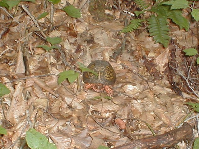
(visited by Richard Westcott and Dave Reichard) 11-Aug-2001 -- First off, our congratulations to the hearty soul(s) that actually reached the confluence at N37 W83. This confluence is located on the side of one SERIOUSLY MONSTROUS, OUTRAGEOUSLY STEEP hill. They reached the confluence on the same day we attempted, but we never crossed paths. I eagerly await their report. Anyway, here's our report: The voice navigation from the laptop was flawless and this made the trip from just north of Cincinnati to south eastern Kentucky relatively uneventful. The roads approaching our first confluence of the day had "S" curve signs placed about every half mile. The locals buzzed by us as if we were standing still. Heeding the call of nature, we stopped at local store a few miles from the confluence. There was a sign in the rest room that read (I kid you not) "Please flush commode after use". We arrived near the confluence site at around 14:15. Just our luck, it started to rain as we arrived. There were houses on either side of the road and we asked a teenaged boy who owned the land across the street. We were introduced to his mother. We presented the form letter from the Degree Confluence Project and attempted to explain its goals. We parked next to a building the landowner called a Church. This area of Kentucky had had a lot of rain recently and the stream running near the Church had flooded. The landowner later explained that the stream had moved claiming 20 feet of her property. The stream was narrow and shallow and would not be difficult to cross, though we would get our feet wet. We waited for the rain to abate a bit before we set out on our trek. After about 20 minutes, the rain slowed to a point where we thought we could make our start. According to the Garmin, where we parked, we were .33 miles to the north of the confluence. We had to walk about 60 meters west to find a place shallow enough to cross the stream. After getting our feet wet, we surveyed the hill we had to climb. At this point, I would like to digress a minute to offer a very valuable piece of advice to other first time confluence hunters: Read your topographical maps carefully! I mean it! This hill is almost 100% grade and covered with fairly new growth trees... and we had a third of a mile to go. The aerial photos we had were black and white, old and deceptive. The photos didn't even include the Church on the property. "A third of a mile..." we thought, "... we can walk a few miles with out batting an eyelash, this ought to be a piece of cake." BZZZZZZZT! Wrong answer! Anyway, back to our story ... We waded through knee high grass back east to a point where the trees opened a bit and we started our assent. Ten meters up the hill, we ran into a wire fence that was easy to get over. We continued climbing, going from tree to tree, occasionally grabbing a dead tree and stumbling. Because of the recent rains, the ground was wet and gave way easily, impeding our assent. After climbing only 30 meters, my heart was pounding and I was sweating buckets. We rested and took our bearing. We still had over a quarter of a mile to go. We pressed on, moving about 30 meters at a time and stopping. When we had reached about 100+ meters up the hill, the clearing we started from had disappeared and we began to re-evaluate our plan of attack. This hill was not meant to be assaulted by two fourtyish geeks out for a day of fun. The Etrex still read almost 300 meters of lateral distance between the confluence and us. That left better than 420 meters of hill yet to climb. Dave was ahead of me by about 35 meters. I was leaning on a tree, panting and close to death (or so it seemed). Several times the question was raised: "Can we make it?" Finally the answer was "I may be able to make it up eventually, but if I did, I couldn't make it back down." We debated briefly the impact of this "little" climb on our health and decided to chalk this confluence up as an attempt. The very real risk of injury from the wet, rocky ground, coupled with the fact that neither of us was in any shape* even resembling being physically fit, outweighed our desire for fame and glory as confluence hunters. Dave communicated the vital statistics to me, snapped a photo of a hill denizen, and we turned back. According to the statistics I wrote in my Palm V (side note: I'm not quite sure how my Palm V survived that trek up the hill, but it did), our position was N37° 00.112 and W83° 00.125, so close, yet so far away. That left only 280 meters of lateral distance to go at a bearing of 145° at 24 meters of accuracy. Our elevation was 474 meters and the time was 16:50. Not close enough to score a hit. Rats. In conclusion, this was a tough confluence for first time confluence hunters. We thought we were prepared. We certainty weren't lacking in equipment. In retrospect, if we had read the topographical maps a bit more closely, we would have realized our folly. Assaulting that hill head on, even on a dry day, was a big mistake. If we had it to do over again, there are two things we would do differently: one, RTFTM (read the FINE topographical maps) and two, possibly hire a Sherpa (i.e.: a local teenager who has been up that hill a million times) to aide in our assent. Sometimes experience is the best teacher. Did we mention that this hill was REALLY FREAKING STEEP? :) Our journey continues on to N38 W83 ... * I am in shape ... round is a shape, right? :) |
| All pictures |
| #1: View up the big hill #2: View down the big hill #3: A big hill denizen #4: View of the big hill from the road #5: Did we mention that this is a REALLY STEEP BIG hill? :) ALL: All pictures on one page |