|

Morocco
1.0 km (0.6 miles) N of Douar al Groun, Marrakech-Safi, Morocco
Approx. altitude: 448 m
(1469 ft)
([?] maps: Google MapQuest OpenStreetMap ConfluenceNavigator)
Antipode: 32°S 172°E
Accuracy: 4 m (13 ft)
Quality: good
Click on any of the images for the full-sized picture.


| 32°N 8°W (visit #1) |
![Visit #4: [26-Dec-16]](/ma/all/n32w008v4/preview.jpg "Visit #4: [26-Dec-16]")
![Visit #3: [16-May-16]](/ma/all/n32w008v3/preview.jpg "Visit #3: [16-May-16]")
![Visit #2: [26-Jun-08]](/ma/all/n32w008v2/preview.jpg "Visit #2: [26-Jun-08]")
")
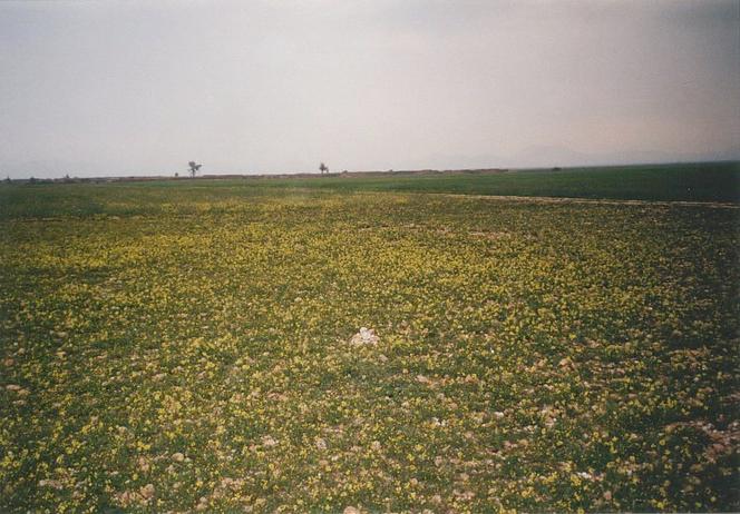
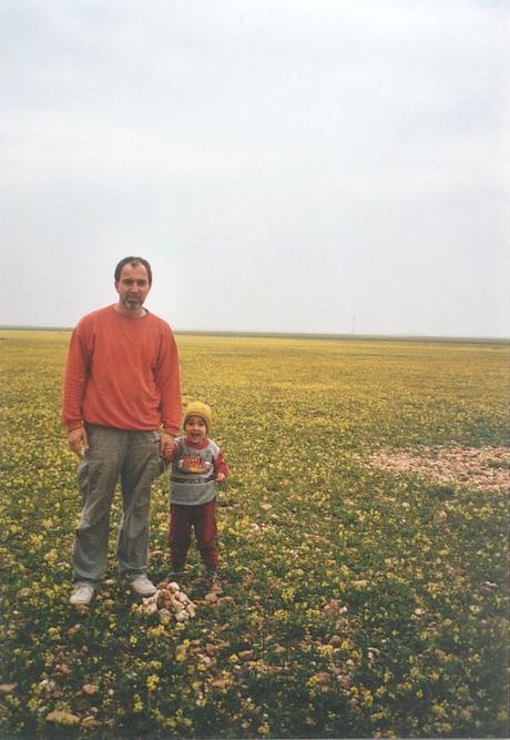
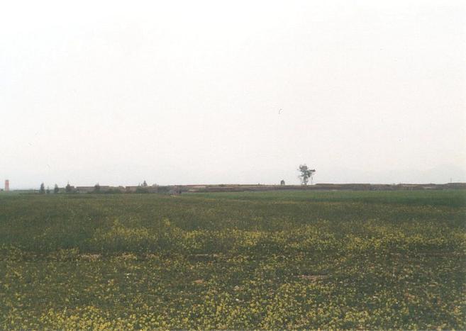
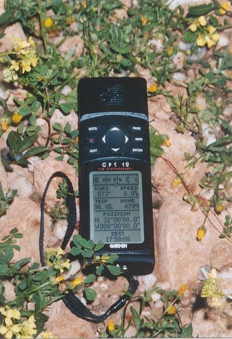
(visited by Gerhard Kaufmann, Jamila Ahejjam and Marwan Kaufmann) 18-Apr-2002 -- This day we had already tried to get to the Confluence 31°N 9°W, but fate hadn't granted us success there. So we drove on following the road P 40, descended from the High Atlas mountains passing the village of Imi n-Tanut ("Mouth of the Little Well" in Tašilḥit language), and then drove through the al-Hawuz plain north to Šīšāwa and along the P 10 east to Mrrakš, where we arrived at about 5 p.m. This was unexpectedly still early enough to give it a try with the Confluence 32°N 8°W the same afternoon, instead of postponing it till the next morning, as my roadmap indicated that this Confluence lies only 40 km north of Mrrakš quite near to the main road P 7 going to al-Dār al-Bayḍā' (Casablanca). First, we had to pass through Mrrakš and find the right way to the Casablanca road. But that sounds much easier than it really was, because driving in Mrrakš during the rush hour is a sh** lousy job to do! The roads in the new city are very good, large and often with two lanes for each direction. But you have to cope with three demanding tasks all at the same time: 1. You have to find your way through the quite large city. Signs indicating where to go are very sparsely placed, and of course never where you would need them most. Besides there are a lot of traffic circles, which make you lose the orientation very quickly. But after all there is at least one consolation: After you have left the city already for some kilometres only relying on guesswork for taking the right road, then you will find a big sign telling you where you are really going to... 2. There are obviously only two traffic rules to be obeyed, the First being: "Use any (this means ANY) opportunity offered by the route and the traffic around you to get in front of the other road-users." This rule is especially applied by the moped riders swirling like a swarm of bees among the cars, and by the numerous taxis. A very fine opportunity to comply with this First Rule is offered at traffic lights, when in a road with two lanes for each direction already three cars and some mopeds are stopping side by side at a red light. In general, there should be at least the possibility for one more car to pass the waiting ones at the left or right side to gain a lead over the others by half a car's length. But the First Rule can also be applied very favourably in those traffic circles with their countless opportunities to overtake the other road-users on any side, or to cut in on them. 3. The Second Rule is: "Yellow traffic lights are equivalent to red traffic lights." So be sure always to perform an emergency braking when approaching a traffic light that is turning from green to yellow. This is simply to avoid annoyance for the omnipresent traffic policemen. (Sorry, I think this will need a little explanation: As the First Rule doesn't need any supervision by the policemen, they can devote all their time to the supervision of the Second Rule. If they catch a Moroccan driver violating the Second Rule, they will stop him, explain to him his offence and ask him - to hand over his driver's licence which the driver will be able to claim the next day from the courthouse after having paid his fine - or "something else"... Something else? Oh yes, of course, there exists always a short cut of this procedure. The policemen in general will prove very accommodating and turn a blind eye if the Moroccan driver has got a little spare money at hand, half of the regular fine should be sufficient. Very regrettably, this won't work with foreign drivers, so they will only get a verbal warning and can drive along. But the policeman of course is very annoyed for having done his hard job literally for nothing.) We finally found the right road to Casablanca after some enquiries at a petrol station already on the way to Asfī. After leaving Mrrakš, the road P 7 lined with countless date palms crosses the river Wādī Tansift on a long bridge, passes through the Jbīlāt ("Small mountains" in Moroccan Arabic), now in springtime abundantly covered with flowers, and then runs absolutely straight for tens of kilometres northward over the Bahīra plain. On the roadside, many local farmers sold melons to the passing travellers. When my GPS receiver indicated that we would soon pass the Confluence on our left side, I looked for a smaller road in this direction and luckily found the turn-off of a quite broad dirt road at 31°59'20"N 7°56'53"W. This dirt road, at first leading in a south-western direction, crosses the single-track, but electrified railroad Mrrakš-Casablanca, passes near a small village (probably the village of Bū Naga which is noted on the maps, but I didn't verify this), then turns to a northern direction and soon again to west, heading nearly exactly towards the Confluence. After about 5 km passing through barley fields another village came into sight. Near to this village, many tracks criss-crossed the land, so when my GPS receiver guided me now a little more in this or that direction, I always found a suitable cart-track or donkey-path to keep the overall direction towards the Confluence. In this manner, we drove into this village named Duwwār al-Grū, being given a hearty welcome by some barking dogs and amazed looks by some inhabitants. I already thought of the Confluence lying inside this village, but we passed a narrow path between two of the flat clay brick houses, and all of a sudden had left the small village again. At this moment, I nearly couldn't believe the fortunate circumstances we met here. It was now nearly 6 o'clock p.m. GMT (UT + 0), the sun was already sinking low, and we hadn't much time left to perform a long search for the Confluence. All around us were many large barley fields, and the probability was quite high that the Confluence would lie in the middle of such a field, so that we couldn't get to it without permission and the loss of much time. But the GPS receiver indicated only 500 m remaining to the Confluence, and we were still able to drive on a gravel-covered cart-track exactly in its direction! Some minutes later I was really baffled by our luck: The Confluence 32°N 8°W was lying a mere 15 m beside the cart-track in a patch of land only covered by herbs, little yellow flowers and stones (Picture #1). Some metres east of the Confluence was an eye-catching round spot (Picture #7) formed of the stones that lay all about, but I couldn't find out if this had anything to do with it. So I piled up a small heap of the many quartz stones scattered among the others, took my photos in the already fading light (the sky being overcast and a slight drizzle in the air now), and enjoyed this moment of success at our second Confluence in two days. This one had been as easy to reach, as the first had been strenuous. The scenery all around was as flat and bare as a plain only can be, even the nearby village hardly standing out and the Jbīlāt hills vanishing in the haze far away to the south (Picture #4). The GPS receiver (Picture #6) indicated an altitude of 479 m and an accuracy of 4 m. We returned the same way back to Mrrakš, where we arrived after dusk, and soon found the small hotel that we already knew from another visit two years ago. We were now all very tired after having driven more than 400 km this day. Oh, I nearly forgot to mention: While searching for the hotel, I once committed the offence of not applying the Second Rule, and therefore was stopped and received the verbal warning for foreigners. But I must confess: No, I wasn't sorry at all for the policeman's annoyance! Narration began at 30°N 9°W and will be continued at 32°N 9°W |
| All pictures |
| #1: The Confluence 32°N 8°W seen from NE (Confluence marked by heap of stones) #2: View towards north from Confluence #3: View towards east from Confluence #4: View towards south from Confluence. The houses of the village Duwwār al-Grū are only 500 m away #5: View towards west from Confluence. The cart-track brought us really near to the Confluence #6: GPS receiver display #7: My son and me at the Confluence. The mysterious patch of stones to the right. ALL: All pictures on one page |