|

Morocco
24.1 km (15.0 miles) SW of Imi-n-Tanoute, Marrakech-Safi, Morocco
Approx. altitude: 1137 m
(3730 ft)
([?] maps: Google MapQuest OpenStreetMap ConfluenceNavigator)
Antipode: 31°S 171°E
Accuracy: 6 m (19 ft)
Quality: good
Click on any of the images for the full-sized picture.
")


| 31°N 9°W (visit #2) |
![Visit #3: [03-Nov-25]](/ma/all/n31w009v3/preview.jpg "Visit #3: [03-Nov-25]")
![Visit #1: [18-Apr-02]](/ma/all/n31w009/preview.jpg "Visit #1: [18-Apr-02]")

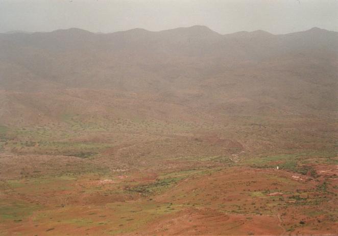
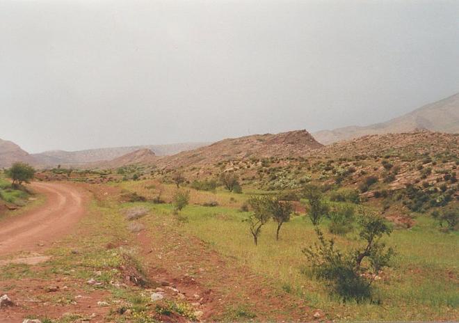
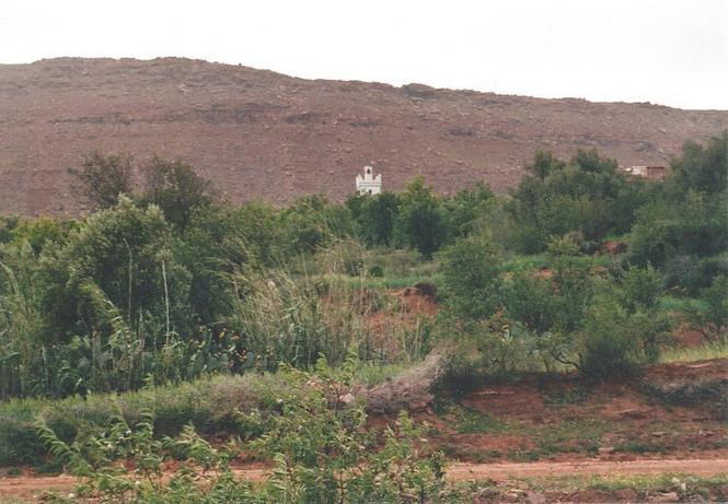
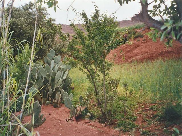
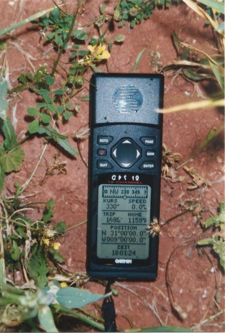
(visited by Gerhard Kaufmann, Jamila Ahejjam and Marwan Kaufmann) 20-Apr-2002 -- Coming from our visit to the Confluence 32°N 9°W, we arrived the day before at the city of al-Ṣuwayra (on maps it is usually written Essaouira, the Berber population calls it Taṣṣurt, the name means "Little Fortress" in Arabic). This town is very remarkable because of its ancient port, its city walls and its picturesque old town, all dating back to the 18th century, and besides it is remarkable because it is the city with the mildest climate in Morocco. All over the year, the average temperature is nearly constant at about 20°C and most of the time a strong wind is blowing from the sea. After our arrival yesterday, we already went for an extended walk in the crowded streets of the city, and also this morning after having a rich Moroccan breakfast with Harīra soup, eggs, Lmsmmn pancakes (no, I didn't forget the vowels, there are none!), and French croissants and pain au chocolat at our hotel on the promenade, we continued our sightseeing until 11 o'clock. Until then, I had already decided that we should give the Confluence 31°N 9°W a second try. After our failure two days ago, when our nearest approach ended 3.3 km from it, I knew that I would always think of this Confluence as "Why didn't I try it again?" if I didn't venture it - be it on foot or be it on hands and knees! So we didn't return to Agadir on the coastal road P 8 as had been my original plan, but instead we took the eastern road P 10 towards Mrrakš until arriving at the crossroads in Šīšāwa, and then the already well-known mountain road P 40, southward bound towards Agadir. At about 3 o'clock p.m. we were near to the closest approach of the main road to the Confluence, where I already had taken a picture at our first visit. We left the car near a farmhouse and started hiking towards the hill chain. At first, we crossed some fields with almond trees, but soon we had to find again a way around large barley fields, until we arrived at some farm houses at the foot of the hills. As I had already noticed from the road, the hills were easy to climb because their surface consisted of large sandstone slabs in a more or less constant inclination, and there wasn't much rubble hindering our ascend. Most of the time I carried my little son Marwan, and as we climbed up quite fast, I quickly got exhausted and often had to put him down to relax my arms and legs. Moreover we noticed that being so eager to tackle the way to the Confluence, we had forgotten to eat something before starting the hike. When we reached the first crest of the hills, we saw that there was a small valley behind where we found among other plants a species of palm trees only 20 cm high. Beyond the valley we had to climb another slope rising even higher. On top of it, we found again a small valley to cross, but on the other side the hills did no longer rise much more, now we had reached the summit of this hill chain. And then we found what I had already slightly feared all the time: We stood on the edge of a very steep cliff, high over the valley of the Asif n-Ayt Mūsā (Picture #2), with apparently no way down! It was now 4 p.m., when I checked our position I found that we were still 1.8 km NW of the Confluence, which clearly was to be found deep down in the valley. We had climbed to an altitude of nearly 1440 m, more than 100 m higher than we had left our car. But all this was not done in vain; on the contrary, it turned out to become the key to our final approach to the Confluence! On the hills was a herd of goats grazing, and our presence had also caused a man to come to us, curious about what these strange people were doing in this place. He confirmed that there was no way down into the valley, but he also pointed out that there would be the possibility to drive on a dirt road into the valley from a small market town next to the main road, only a few kilometres north of where we had left our car. This gave us hope again, and as we could achieve nothing more on these hills, we descended and returned to the car as quickly as possible. When we arrived, a slight rain started to fall upon us, and of course, the first thing to do was to make up our forgotten lunch... I drove back a short distance north on the road P 40 and in fact, there was a small village that I hadn't taken notice of before. And a dirt road branched off at 31°2'44"N 9°1'27"W in the direction of the hills. Neither this town called Aflla Issn nor the road were marked on my roadmap, or else things would have had developed totally different from the beginning! When driving through the village, some men pretending importance stopped us and harshly demanded some money, but they didn't explain why. At first I felt like having fallen among thieves, but they demanded only 2 Dirhams (0.18 US-$/0.20 €), gave me a kind of ticket in return, and let me drive along. It was not before I took a glance at this ticket that I knew why we had been "robbed": Today being Saturday was the weekly market day in this village, obviously every car entering the village on this day had to pay this special "market toll". We drove along the dirt road and what could not easily be seen from the main road: There was a gap in the hill chain, where the road passed through; a creek that rose in the plain near the village also used this gap. Deducing from the village's name meaning "Above Issn" in Tašilḥit language, it was not the source of the Asif n-Ayt Mūsā itself but more likely a tributary named Asif Issn instead. The road descended to the valley beyond the hills in the gorge of this small river. At this time, it was no longer running with water, but there were still many pools full of water between the rocks. And this river had still another surprise for us in store, as the - until then quite good - dirt road had to cross the riverbed at the bottom of the valley. I suppose that this ford normally is prepared for cars to pass more easily, but the recently running river had washed it out and left a 5 m wide stretch of large boulders. But being now so near to this stubborn Confluence, I was ready to dare nearly everything to get to it! So I stepped off the car, put aside some of the loose boulders, and searched for the least dangerous passage for our car. Proceeding very, very slowly and cautiously, looking under the car again and again (my mind being put a little at ease when I saw that there was a protective metal plate welded under the motor block), I finally succeeded in reaching the other bank. The rest of the way (Picture #8) to the Confluence 31°N 9°W was now only a children's play, and we found it after some kilometres, only 20 m beside the road. A small footpath branched off the road, leading to a nearby village called Tizi n-Girin (Picture #9) with a white minaret, which had been already an outstanding landmark when we had looked down from the top of the cliff. The Confluence was located in a small barley field 2 m north of the footpath, only one step beside an opuntia cactus (Picture #1). So this again was a Confluence where people every day pass by VERY close. The scenery all around was very nice with lots of almond, fruit and olive trees, cacti, green fields and red soil. It was now 6 p.m. GMT (UT + 0), the GPS receiver (Picture #7) indicated an altitude of 1159 m and an accuracy of 6 m. This meant that on top of the cliff, now towering up high in the west, we had been nearly 300 m above the valley! Some women and a man had come to our car, they told us that there was another connection to the asphalt road 14 km along the dirt road, but it was now only one hour left until sunset and we didn't dare to find some more surprises along the carriageway. So we returned via the already known route, even when this meant another crossing of the washed-out ford. While driving along the main road to Agadir, we found in fact a smaller road branching off 12 km S of the Confluence with a signpost pointing to a mine, and of course not marked on my roadmap either. We arrived at Agadir after dark, the next morning we would have to return the car to the rental. We had driven 1270 km and successfully discovered four new Confluences in four days. This was already more than could be expected. But we still had further plans... Narration began at 30°N 9°W and will be continued at 33°N 8°W |
| All pictures |
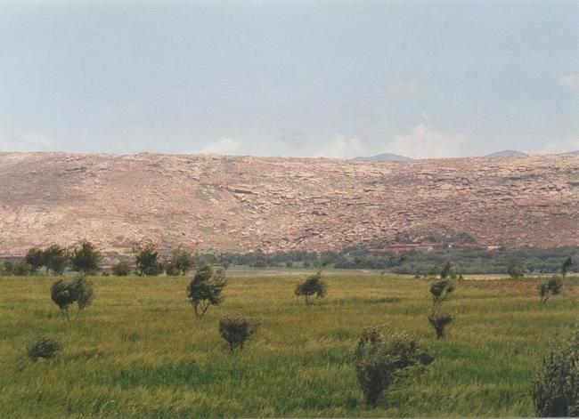
| #1: The Confluence 31°N 9°W in the barley field close to the cactus #2: View from the top of the cliff into the valley of the Asif n-Ayt Mūsā (Confluence close to the white minaret in the lower right corner) #3: View towards north from Confluence #4: View towards east from Confluence #5: View towards south from Confluence #6: View towards west from Confluence #7: GPS receiver display #8: Road leading close to the Confluence #9: Village Tizi n-Girin above the Confluence, 300 m high cliff in the background #10: My son and me at the Confluence ALL: All pictures on one page |