|

Argentina : Río Negro
22.1 km (13.7 miles) SSW of Punta Villarino (Cape), Río Negro, Argentina
Approx. altitude: 0 m
(0 ft)
([?] maps: Google MapQuest OpenStreetMap ConfluenceNavigator)
Antipode: 41°N 115°E
Accuracy: 5 m (16 ft)
Quality: good
Click on any of the images for the full-sized picture.


| 41°S 65°W |

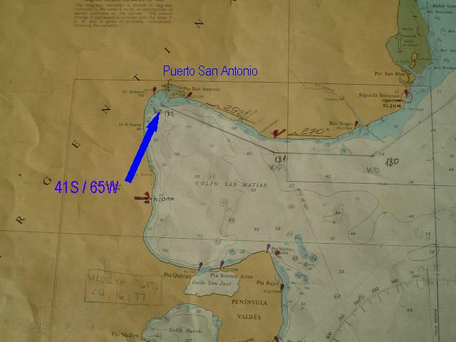
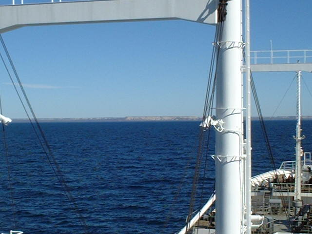
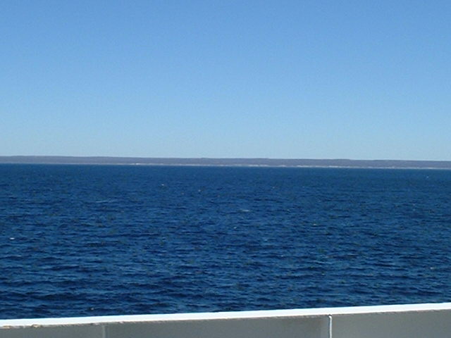
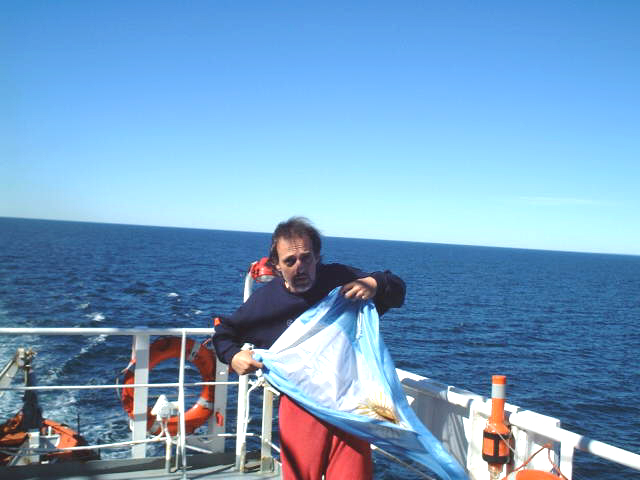
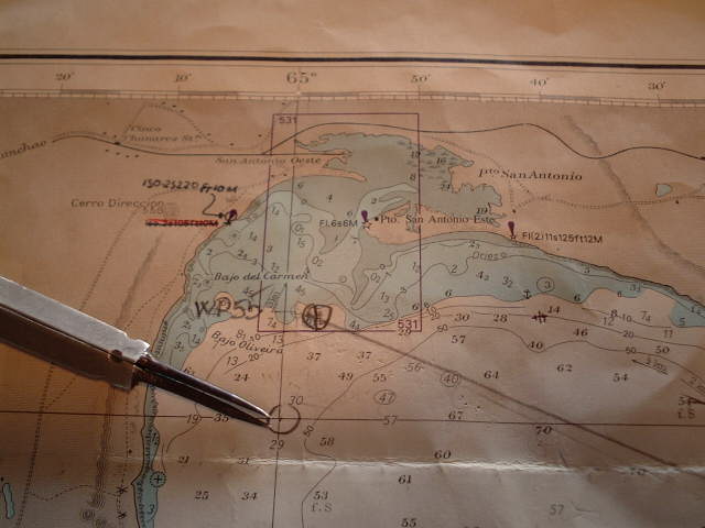
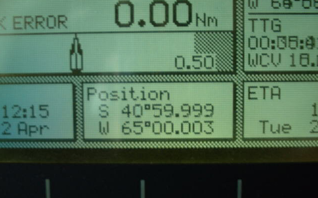
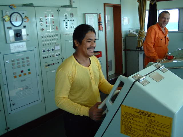
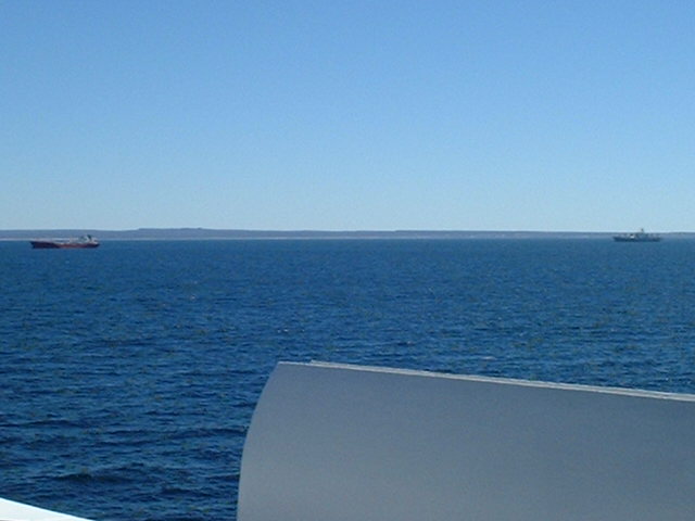
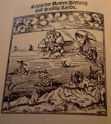
(visited by Captain Peter, Valentyn Smirnov, Volodymyr Kokorev and Volodymyr Sydorenko) 02-Apr-2002 -- After loading at Campana on 30-Mar-2002, we arrived in the Golfo San Matías on 02-Apr-2002, to continue loading the empty spaces with apples and pears at the Port of San Antonio Este. The North coast of the Gulf consists of high sandhills, which form cliffs in places. Farther West it reverts to a low sandy beach extending until Puerto San Antonio. The West coast of the gulf appears as cliffs from the offing, but actually is land rising gradually from the shore to the high ground of the interior, where some ranges of hills are prominent. The shore is narrow beach of sand, moss or gravel. The land, typical for Patagonia, is treeles, almost sterile, with rough pasture and scrub and scattered habitation. As it is good seamanlike courtesy practice, in territorial waters the flag of the visited country has to be hoisted. Here Captain Peter is preparing the Argentine flag. Prior arrival at San Antonio, we could visit 41°S / 65°W at 12:15hrs. According to the GPS we were only a 5 meters m too much in the NW, on 40°59.999'N and 65°00.003'W. Every visit to an offshore Confluence is as well a good exercise and drill for perfect and exact steering. Here seaman Leslie Napa from the Philippines is acting as Quartermaster. A few miles North of the Confluence we arrived at the outer roads of San Antonio, where we had to drop anchor. Some competitors, awaiting as well the free berth for loading, are already around. The Gulf of San Matías is as well linked with Magellan's voyage around the world. So let's continue on his traces. After having been so disappointed when realizing the Mouth of the Rio de La Plata not being the passage between the Atlantic Ocean and the South Sea he proceeded farther towards South. Stefan Zweig's famous description of Magellan's voyage describes his desperate sailing along this coast, searching for the passage Here first the original German text of this famous writer in his beautiful language: "... immer mühsamer, immer langsamer wird die Fahrt, denn unerbittlich hält Magellan Kurs an der Küste nach Süden. Jede kleine Bucht wird aufs gründlichste durchforscht und mit dem Senkblei durchsucht. Magellan vertraut jener mysteriösen Karte, die ihn erst zur Reise verlockt und dann verraten, schon längst nicht mehr. Aber vielleicht geschieht das Wunder, daß plötzlich an unvermuteter Stelle der "paso" sich zeigt, und sie doch noch hinübersteuern können ins "Mar del Sur"! ... ... als die Flotte am 24. Februar 1520 sich abermals einer breiten und unübersehbaren Bucht, dem Golfo San Matías, nähert, flackert wie eine vom Sturm gefaßte Kerze noch einmal Hoffnung hoch. Sofort läßt Magellan die kleineren Schiffe wieder vorausfahren, "viendo si habia alguna salida para el Maluco", ob nicht hier die ersehnte Durchbruchstelle zu den Molukken sei. Aber wieder nichts! Wieder eine geschlossene Bucht! ... ... Zweimal - das erste Mal bei der La-Plata-Mündung, das zweite Mal bei der San Matthias-Bai - grausam enttäuscht, kann der "paso" nur tiefer gegen Süden, also näher an der antarktischen Zone, liegen. ... Findet er ihn nicht, so ist alles verloren ... weiter, weiter also geht unter dem verdüsterten Himmel die Fahrt. Immer grauenhafter wird die Öde, immer kürzer werden die Tage, eisige Stürme reißen jetzt wild an den Segeln ... English translation: "... more and more troublesome becomes the voyage, as Magellan is heading mercilessly along the coast towards South. Every small bay is meticulously surveyed with the sounding lead. Magellan no longer trusts his mysterious chart [link pic 06NeweZeytung, text: the leaflet with the erroneous information about the passage from the Atlantic to the Pacific Ocean], having him first tempted to undertake this voyage, and then traited. But probably a miracle will happen, and suddenly on an unexpected place the "paso" will show up, and they will be able to head towards the "Mar del Sur"! ... ... when the fleet approaches again a large and vast bay on February 24th, 1520, the Golfo de San Matías, hope flickers up, similar to a candle's flame in the storm. Immediately Magellan orders the smaller ships to go ahead, "viendo si habia alguna salida para el Maluco", whether there is the breakthrough to the Moluccas they are longing for. But again nothing! Again a closed bay! ... ... Twice - the first time in the mouth of the La Plata, the second time in the Bay of San Matías - terribly disappointed, the "paso" is supposed to be more in the South, thus closer to the Antarctic zone. ... If he won't find it, all will be lost ... onward, onward the voyage continues under the gloomy sky. More and more horrible the wasteland, shorter and shorter the days, icy storms are now straining violently on the sails ... It remains to explain where the word "Patagonia" comes from: The country was already named so on Magellan's voyage: One morning a native appeared, and Pigafetta, the reporter who accompanied Magellan, wrote in his diary: "duobus humanum superantes staturam" (of twice a normal man's height). Magellan and his people are admiring especially his large feet, and thus they call him "PATAGÃO" - "Bigfoot"). And accordingly the land is called PATAGONIA, "Land of the Bigfeet") Remarkable, too, was the appetite of this Bigfoot: Stefan Zweig writes: "... mit aufgerissenen Augen beobachtet die Mannschaft, wie dieser Gargantua einen ganzen Kübel Wasser mit einem Schluck aussäuft und einen Korb Zwieback nachstopft wie eine Pfeffernuß ..." ("with wide open eyes the crew is watching how this giant is emptying an entire bucket of water with a single gulp and subsequently stuffing in his mouth a full basket of rusk as it was just a nutmeg ...") Well, this was the southernmost point for this voyage. The loading will be completed here and then we are bound for Saint Petersburg in Russia. It's really a pity this time I cannot follow Magellan, because I looooooove the Cape Hoorn too much ... it's just always so calm and peaceful over there ... 02-Apr-2002 -- Y para mis amigos argentinos, aquí la traducción en castillano: Después habendo cargado a Campana el 30 de marzo de 2002 llegamos en el Golfo San Matías el 2 de abril de 2002, para continuar de cargar de las manzanas y peras en las bodegas todavia vacías en el Puerto de San Antonio Este. En la costa Norte del golfo hay colinas de arena y algos escollos. Mas en el Oeste la costa es más baja y se extiende hasta Puerto San Antonio. La costa Oeste del golfo aparece cómo escollos cuándo visto dal mar, peró en verdad el país crece gradualmente desde la costa hacía la región elevada en el interior, dónde algos colinas son sobresaliendas. La playa es estrecha y de arena, musgo y guijo. El país, - así tipico para la Patagonia - no tiene árboles, es casi estéril, hay sólo pastos ásperos con matorral y sólo población aislada. Cómo es buena y tradicional práctica de cortesía en la marina, en las aguas territoriales se iza siempre la bandiera del país visitado. Aquí Capitán Peter Here Captain Peter está preparando la bandiera argentina. Antes de llegar a San Antonio hemos visitado el punto 41°Sur / 65°Oeste a las horas 12:15. Sigún el GPS nuestra posición está sólo 5 metros demasiado en el Norte-Oeste, exactamente en 40°59.999'N and 65°00.003'W. Cada visita de un punto confluencial es también un buen ejercicio para el timonel. Aquí vedemos el marinero Leslie Napa de las Filipinas. Pocas lleguas en el Norte del punto llegamos a la rada de San Antonio, dónde hay qué fundear y esperar para el muelle libre. Algos navíos refrigerados competedores, también fundeados y esperandos, ya se hallan en posición. El Golfo San Matías es también junto con el viaje a redondo del mundo de Magallanes. Continuamos a seguirlo: Después el desengaño terrible en el Río de La Plata donde realizó que la embocadura de este Río no es el pasaje entre el Atlantico y el Mar del Sur continua a proceder hacía Sur. Stefan Zweig, un escritor célebre alemán describe con su idioma maravilloso en su historia del viaje de Magallanes la navegación desperada a lo largo de la costa argentina buscando el pasaje: "... siempre más fatigoso, siempre más lento se hace el viaje, pues Magellan continua insaciablamente hacía Sur a lo largo de la costa. Cada pequeña bahía se mede y cachea exactamente con la plomada ... Magellan desde mucho tiempo no tiene más confianza en su mapa misteriosa, la cuál antés lo seducí por este viaje y consecutivamente lo traicionó. ¡Peró probablamente sucederá todavia el milagro, y qué de repente en un lugar imprevisto se abre el "paso", y así todavia podrán navegar hacía el "Mar del Sur"! ... ... cuándo la flota el 24 de febrero 1520 se acerca de nuevo a una grande y infinita bahía, el Golfo San Matías, la esperanza se recrudece cómo la llama de una vela en una tormenta. Imediatamente Magallanes envia adelante los navíos más pequeños, "viendo si habia alguna salida para el Maluco" ... ¡Peró de nuevo nada! De nuevo una bahía cerrada! ... ... Dos veces - la primera vez en el Río de La Plata, y la segunda vez en el Golfo San Matías cruelmente desengañado, el "paso" puede hallarse solamente más en el Sur, así mas vecino a la región antárctica. ... Se no hallan el paso, todo será perdido ... ¡adelante! Adelante va la navegación debajo del ciel tenebroso. Siempre más horrible si presienta el desierto y la soledad, siempre más breve los días, tormentas glaciales tiran violentamente a las velas ... Explicamos todavia de donde viene la palabra "Patagonia": Ya durante el viaje de Magallanes se bautizáron así el país: Una mañana aparecé un indígeno, y Pigafetta, el reportero italiano acompañando Magallanes, escribe en su diario: "duobus humanum superantes staturam". Magallanes y su tripulación admiran especialmente sus piés largos y así lo llaman "PATAGÃO" - pié grande - y pues el país se llama PATAGONIA. Estaba considerable su apetito. Escribe Stefan Zweig: "Observan con admiración y ojos anchamente abiertos cómo este gigante toma un balde de agua entero con un sorbo único y después hace seguir una cesta llena de bizcocho cómo se fosse sólo una pequeña noce moscada ..." Bueno, eso es el punto mas meridional de este viaje. El navío estará lleno después haber cargado a San antonio Este y vamos a San Pedroburgo en Rusia. Es realmente una lástima qué esta vez no puedo deguir más el Magallanes, porqué yo aaaaamo demasiado el Cabo de Hornos ... Es una zona así calma, pacífica y tranquilla ...
-------------------------------------------------------- |
| All pictures |
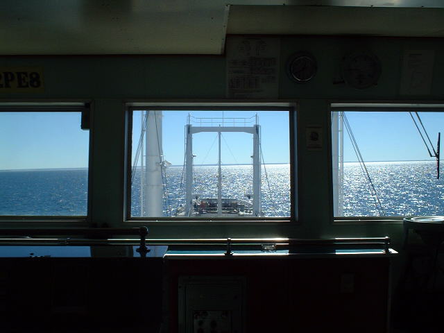
| #1: it's an optical illusion, not a cliff, it's just the gradually rising coast seen from the confluence #2: Map of the confluence in the Golfo San Matías #3: the Patagonian Sun reflects brightly on the waters of Golfo San Matías during approaching #4: the "Westend" of Golfo San Matías, seen from the Confluence #5: Captain Peter prepares the courtesy flag for hoisting #6: Detail map of confluence area #7: GPS #8: Leslie Napa from the Philippines is acting as Quartermaster #9: other refrigerated cargo ships awaiting berthing and loading at anchor #10: the leaflet with the erroneous information about the passage from the Atlantic to the Pacific Ocean ALL: All pictures on one page |
| Notes |
|
In the Golfo San Matías, about 12.5 km from shore and with a view of land. |