|

Canada : Alberta
17.9 km (11.1 miles) W of Saskatchewan River Crossing, AB, Canada
Approx. altitude: 3083 m
(10114 ft)
([?] maps: Google MapQuest OpenStreetMap topo topo250 ConfluenceNavigator)
Antipode: 52°S 63°E
Accuracy: 6.1 km (3.8 mi)
Quality: good
Click on any of the images for the full-sized picture.


 and Mount Lyell (C)")


| 52°N 117°W (visit #2) | (incomplete) |
![Visit #4: [14-Aug-08]](/ca/ab/n52w117v4/preview.jpg "Visit #4: [14-Aug-08]")
![Visit #3: [25-Aug-07]](/ca/ab/n52w117v3/preview.jpg "Visit #3: [25-Aug-07]")
![Visit #1: [28-Jul-01]](/ca/ab/n52w117/preview.jpg "Visit #1: [28-Jul-01]")

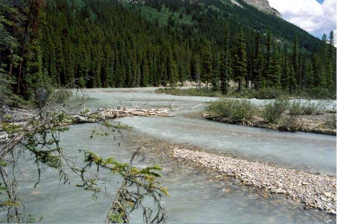
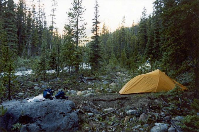
(visited by David Wasserman and Mike O'Toole) 20-Jul-2002 -- An unsuccessful confluence visit attempt is a piece of unfinished business that tugs at the mind. Mike and I immediately began to plan our next attempt after our failure to reach Canada's highest primary confluence point in July of 2001. We analyzed our first effort and identified two major flaws. We hadn't allowed enough time, and we had been unprepared to ford Arctomys Creek when it turned out to be a raging mountain torrent. The revised plan increased the time allowed from two days to three, changed the crossing place to the wider and presumably shallower and less violent mouth of the creek, and saw both of us upgrade our equipment. Mike bought a trekking pole (I already had one), essential for fording, and I purchased waterproof sandals (Mike had an old pair of running shoes). The CP is located in a particularly hard-to-reach part of Banff National Park, a high ridgeline above the Valley of Lakes. The ridgeline is on the southern part of the Mount Amery Massif, a typically huge block of rock, ice, and snow that rises across the North Saskatchewan River from the Icefields Parkway. Although the straight-line distance from the Parkway to the CP is only 9.6 kilometres, the point is concealed behind the summit block of Mount Amery from the road. Although this web site gives the approximate altitude of the CP as 2808 metres, the largest scale topographic maps available show that it is above the 10,200 foot contour line on the southern maps, which are on the Imperial system, and above the 3080 metre contour line on the northern maps, which are metric. One source locates the summit of Mount Hooge within less than half a kilometer of the point; the summit is supposed to have an altitude of 3216 metres. Mount Hooge may no longer be considered a separate mountain. Although it is shown on older maps, some as recent as 50 years ago, newer maps don't name it. Researching the confluence, I looked up the account of the first ascent of Mount Hooge, which occurred in 1948 and is recorded in the 1949 volume of the Canadian Alpine Journal. The authors, F.D. Ayres, J.C. Oberlin, and D.M. Woods, say that from their perspective Hooge appeared to be another high point on the summit ridge of Monchy Mountain, and not a separate mountain. They were the first party to climb either Monchy or Hooge. Both mountains, and nearby Willerval, were named after villages that figured in the fighting on the Western Front during the First World War. I have inquired of the secretariat of the Geographical Names Board of Canada about the status of Hooge's name, and received this reply: "We do not have any record of this name in our data base, either as an official name or an unofficial name. The name has never been submitted to our board for consideration. It does seem odd that the name appeared on the 1953 Parks Canada map and yet there is no record of the name in our files. However, it seems that the name might be used locally despite the fact it has never been submitted to our board for official approval....(T)he name is not considered to be an official name by the Geographical Names Board of Canada, nor do we have any record of the name ever being submitted for consideration." The reply is signed, Tim Matley, Toponymist, Geographical Names Board of Canada. There are two obvious ways to approach the point. The Hooge first ascent party approached from the north side, fording both the North Saskatchewan and the Alexandra Rivers and following the Amery Creek drainage into the heart of the massif. From there they were able to find a precarious series of ledges and gullies that allowed them to attain the summit ridge; it was serious mountaineering in its day and no doubt remains so today. The approach Mike and I chose for both attempts is from the Valley of Lakes to the south of the point. There are no trails into the Valley of Lakes, but a trail and bridge exist to give access to Glacier Lake, the next valley to the south. The maps gave us hope that we would be able to find a route up to the ridge that did not involve technical rock climbing, since neither of us is trained or experienced in that area. The maps were also ambiguous as to whether the ridge was covered with snow, ice, or rock. Although I took a course in snow and ice mountaineering in May, Mike hasn't had the equivalent, and I certainly don't think I'm qualified to lead a trip involving those skills. Thus we chose to assume snow and ice skills and equipment would also not be required. Other skills are obviously necessary: finding one's way through trackless forest, safely crossing unbridged streams, taking care of oneself in the wilderness. For those unfamiliar with what this means, start by thinking about walking. Now imagine walking with a 50-pound (22 kilogram) pack. Next imagine walking with that pack on a spongy, moss-covered surface littered with both upright and fallen trees, some of the deadfall two or three feet above the ground, and waist-high shrubbery. Finally, mentally tilt that surface at about 20 or 30 degrees. Do that from 9:25 a. m., when we left the Glacier Lake trailhead parking, to 8 p. m., when we started setting up camp. Take a few breaks, and remember to drink plenty of water. Oh, and be "bear aware," and remember that a missed step could result in an injury that could require rescue that may be two days away. The first day, July 19 2002, we left the trailhead, crossed the bridge over the North Saskatchewan River, and struck off through the bush along the river's west bank, just as we did on the first attempt. Mike, a more experienced and skilled bushwhacker/routefinder, almost always led the way. This time we stuck closer to the river, a longer but faster route, all the way to the mouth of Arctomys Creek. Just as on the first attempt, though, I once again lost my bear spray from its holster, and once again gave it up for lost. Although the topo maps indicated the creek split into two streams near the river, we found one major channel with a few minor side flows. However, the creek was wide enough to reduce the depth to just over knee deep, with a firm, stony bed. "Did you know that drowning is the leading cause of death in the backcountry?" I asked Mike as we prepared to ford. "No, I didn't. Thanks for telling me that now," he replied. Changing to fording footwear, and either zipping off the lower pant legs (David) or removing the jeans entirely (Mike), we carefully made our way across the icy glacial melt flow, probing and stabilizing ourselves with the trekking poles, our pack waist straps unbuckled as the experts recommend to allow dumping the packs that would drag us down if we fell. Mike went first, dumped his pack on the bank, and came back to photograph my efforts. He advised me to look at the far bank rather than the water, as staring at the ever flowing semi-opaque liquid was quite disorienting. It was sound advice. By the time we finished the ford and rearranged ourselves for bush travel, it was nearly 3 p. m. If we could have arranged to canoe across the river, we could have saved about five hours. The Valley of Lakes is essentially a large hanging valley. In ice ages past, glaciers had carved out both the Valley of Lakes and the North Saskatchewan River valley. The river valley is more deeply carved, so the entrance to the Valley of Lakes is some distance above the river. These geographical truths meant we now had to climb through the montane forest growing over the mixture of moraines and bedrock the glaciers had left behind. And so we did. Moving more or less due west from the ford, we let some distance develop between us and Arctomys Creek to the south, as we knew it would cross our route later. In a couple of hours we were again high above the creek, and at 6 p. m. we stopped for supper, on a point with a fine view to the creek roaring below. Mike cooked up something freeze-dried while I settled for a cold supper of cheese and trail mix. By seven we were moving again, and around 8 p. m. we spotted a flat area well below us beside the creek where we could pitch our tents. Unlike much of the bank, which was usually a steep gravel slope cut through an ancient moraine, or an even steeper bedrock cliff, we found a vegetated and treed hillside that took us down to the creek side. We agreed that the prospect of hauling our packs back up that slope when we moved out would be less daunting in the morning when we were fresh. The area was mostly covered with water-worn stones, but had two suitable sandy patches for our two tents, and Mike found a leaning tree a suitable distance away that we were able to use to hang our food bags from, out of the reach of bears and squirrels. Up to this time it had been warm and mostly sunny, but it started to rain lightly as we pitched our tents. I quickly evolved a technique whereby I assembled the tent and poles under the loosely spread fly, keeping the inner tent dry. By 9 p. m. we were warm and dry in our tents. At that time it began to pour rain, and it rained heavily for an hour. The next morning we had breakfast and set off up beside Arctomys Creek, leaving camp set up and our packs emptied of everything but essentials. The much lighter load was exhilarating, but we had come to the realization there was no way we could make it to the confluence and back this trip. Our camp was still 10.3 kilometers from the CP in a straight line. Our objective became to explore as far up the valley as we could. We made our way to the lowest of the lakes in the valley. It appeared to be quite shallow from the accumulation of glacial flour and possibly avalanche debris; the north side in particular is dotted with snags. We took a break to enjoy our hard-earned view of the rugged peaks that surround the valley. The summit ridge to the north, where the confluence is located, is covered with what appears to be a permanent icecap. At the far end of the valley is Mount Lyell and the Lyell Icefield. We then climbed up the avalanche slope to the north to scout out the view. I stopped at the 1800 metre level, 140 metres above the lake, while Mike continued upward. We arrange to communicate on a half-hour schedule using the FRS radios we had brought along. The views were, of course, breathtaking. After about a half-hour, I set off on a bearing of 83 degrees magnetic toward our camp. The radio communication worked well. After reaching a rockband above the 2000-metre level, Mike also took a bearing on camp and headed back higher up the valley wall. We maintained a fairly constant separation of 500 to 700 metres in an east-west direction, and a varying amount north-south. When I reached a tributary of Arctomys Creek, the first one to flow into the creek from the north after it leaves the lowest lake, I discovered it had carved an impassably deep canyon across my path. I was forced to descend until I was able to cross. There I found a little waterfall about 3 or 4 metres high that I stopped to photograph. I considered the possibility that I was the only human ever to witness this waterfall, as it was well above Arctomys Creek, and not on a route that many would follow, in a place where few traveled anyway. Such are the pleasures of exploring trackless wilderness. I made it back to camp a half-hour or so before Mike, and retired to my tent for a nap. After he returned, we had supper and dragged our tired bodies into our tents for a well-earned rest. Early the next morning we struck camp and once again had 50 pounds on our backs. With some difficulty we found our way back up to the top of the ridgeline north of the river. Sticking closer to this ridge than we had on the way in, and occasionally making our way carefully along the top edge of the gravel slope leading steeply down to the torrent, we eventually heard a lower rumble in the constant roar of the creek. The cause of this became clear when we were able to see back up the valley. There is a major waterfall on Arctomys Creek that is not indicated on our maps. Before noon we reached the mouth of the creek and forded in the other direction. The second ford was less nerve-wracking than the first, since we knew we could do it. Generally following our outbound route, we made good time on the return, in spite of taking regular breaks to rest and to enjoy the wilderness. And, in keeping with tradition, we once again found my bear spray. It had been pulled out of its holster during a stream crossing using a tangle of logs, and was hanging by its handle from a branch just above the water. Mike retrieved it. Since we had encountered no sign of bears, I buried it deep within my pack. By 5:40 p. m. we were back at the trailhead. |
| All pictures |
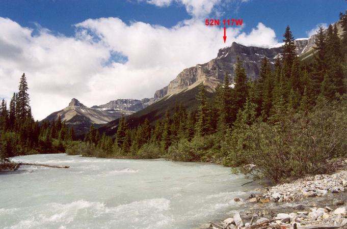
| #1: The confluence is right about ...there! #2: Kilometres of deadfall to deal with #3: Looking back across the ford of Arctomys Creek #4: Our campsite in the morning #5: The lowest lake in the valley, Arctomys Peak (L) and Mount Lyell (C) #6: The Valley of Lakes #7: My waterfall discovery #8: The unmapped Arctomys Falls #9: David fording Arctomys Creek #10: Map and Track ALL: All pictures on one page |
| Notes |
|
In the Banff National Park, about 4.3 km SSW from the 3329 m summit of Mt. Amery. |