|

United States : Florida
6.6 miles (10.6 km) NE of Tequesta (Palm Beach), Martin, FL, USA
Approx. altitude: 0 m
(0 ft)
([?] maps: Google MapQuest OpenStreetMap topo aerial ConfluenceNavigator)
Antipode: 27°S 100°E
Accuracy: 75 m (246 ft)
Quality: good
Click on any of the images for the full-sized picture.


| 27°N 80°W (visit #1) |
![Visit #2: [26-Dec-07]](/us/fl/n27w080v2/preview.jpg "Visit #2: [26-Dec-07]")

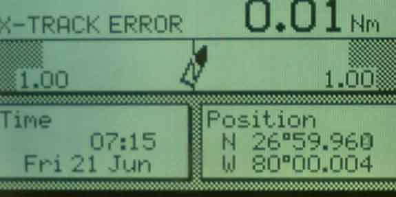
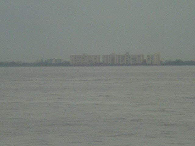
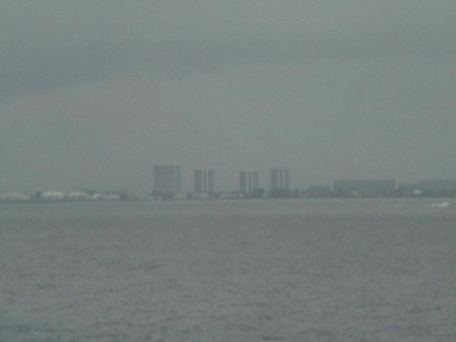
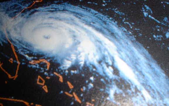
(visited by Captain Peter, Volodymyr Kokorev and Volodymyr Sydorenko) 21-Jun-2002 -- When Captain Peter started to visit confluences in summer 2001, he believed the only country in which he certainly never will be able to visit a point to be the USA. First, because - as far as one can possibly judge - all visitable confluences are already visited several times, and second, - voyages to the US for us are extremely rare. Our ship sails mostly in European, African und South American waters, but after having discharged our Moroccon oranges at Saint-Petersburg (Russia), we received the following order "UPON DEPARTURE S-PETERSBURG, PROCEED AT FULL SPEED AND ON THE SHORTEST ROUTE TO PASCAGOULA/MISS, TO LOAD A FULL CARGO OF FROZEN CHICKEN FOR RUSSIA." Well, and here we are now. After having visited 44N / 60W in Canadian waters, the next land we saw was the coast of Florida, today, on a warm, damp, squally and rainy morning. Of course all points on land in Florida are visited, and we wondered how it is possible that very convenient offshores are still untouched, in a country, where almost everybody owns a yacht, but obviously there is not a single confluence visitor among them. So we decided to go first for 27°N/80°W. At 07:15 am we were at the confluence, fortunately just in a moment when rain was not falling. These tropical showers do not last very long, but when they fall, the visibility is quite reduced. The East coast of Florida is very populated. Looking to NW we saw the charted LORAN-tower, 199 metres (653 ft) high. LORAN (LOng RAnge Navigation) is a now obsolete method of hyperbolic radio navigation, but was very common and convenient before the introduction of GPS on board ships. To the West there is Lake Park, in the WSW is located West Palm Beach, and to the SW finally we see the skyline of the largest settlements in the area, Palm Beach and Lake Worth. Above we mentioned tropical showers. Another far more remarkable atmospheric phenomenon is common in this area: tropical storms, or hurricanes. Although we are not yet in the full hurricane season, - and Captain Peter does by no means want to be there during it - we already should learn something about them: Tropical storms (called hurricanes in the US, taiphoons in Eastern Asia, Willy-Willies in Australia), are intense depressions which develop in tropical latitudes. They are often the cause of very high winds and heavy seas. Although the pressure at the centre of a tropical storms is comparable to that of an intense middle-latitude depressions, the diameter of a tropical storm is much smaller (typically some 500 miles compared with 1,500 miles) and thus the related pressure gradients and the wind speeds are correspondingly greater. The wind blows around the centre of a tropical storm in a spiral flow inwards, anticlockwise in the Northern Hemisphere, and clockwise in the Southern hemisphere. Within the circulation of a tropical storm the wind is very violent and seas are high and confused. Considerable damage may be done to even large and well-found ships. The danger is especially enhanced when ships are caught in restricted waters without adequate room to manoeuvre. Tropical storms are most frequent during late summer and early autumn of each hemisphere. They are rare from mid-November to mid-June in the Northern hemisphere and from mid-May to Novemer in the Southern hemisphere. However it is stressed that no month is entirely safe and that storms may occur at any time. Tropical storms develop only over oceans. In the N hemisphere storms form mostly in the belt 5°-15° North early and late in the storm season, and between 15°N and 25°N at the height of the season. In the Southern hemisphere most storms develop between 5° and 18°S. The storms affecting the Caribbean and US-Gulf e.g. are already developing in the area around the Cape Verde Islands, thus a 4,000 naut. (7,400 km) miles off. Their tracks are very variable and erratic. Very generally, a storm in the N hemisphere will move off in a direction between W and 350°, though most often between 30° of due W. When near Latitude 25° North, storms usually recurve away North and by the time they reach 30°N, movement is in a N-E direction. When a storm moves inland it weakens rapidly and usually dissipates. But if it should re-emerge to follow an ocean track again, it may re-intensify. Storm warnings are regularly issued from local radio stations and Weather Centres. These are normally manned by competent forcasters with long experience and with an optimum supply of latest information at their disposal. However it is sometimes difficult to identify the present position of a storm centre, even with modern tracking facilities. Appropriate allowances are therefore prudent when action is necessary to avoid a storm, and ships should pay particular attention to their own observations when in the vicinity of a storm.
------------------------------------- |
| All pictures |
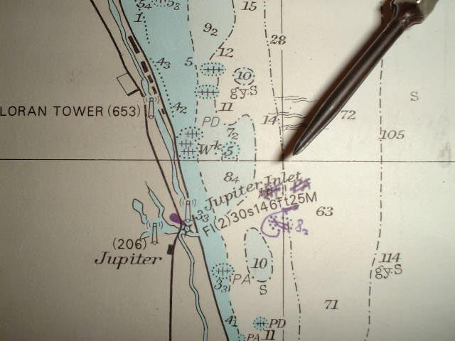
| #1: Lake Park to the West #2: Map #3: GPS #4: Our ship passing through a heavy tropical shower off the coast of Florida #5: Skyline with LORAN-tower, NW #6: West Palm Beach, WSW #7: Skyline, SW #8: Palm Beach and Lake Worth #9: Tropical Storm "Hugo" approaching Charleston SC on 21-sept-1989 ALL: All pictures on one page |
| Notes |
|
In the Atlantic Ocean, but with a view of land. |