|

Morocco
16.6 km (10.3 miles) ESE of Ait Baha, Souss-Massa, Morocco
Approx. altitude: 1158 m
(3799 ft)
([?] maps: Google MapQuest OpenStreetMap ConfluenceNavigator)
Antipode: 30°S 171°E
Accuracy: 6 m (19 ft)
Quality: good
Click on any of the images for the full-sized picture.


| 30°N 9°W (visit #1) |
![Visit #3: [25-Aug-15]](/ma/all/n30w009v3/preview.jpg "Visit #3: [25-Aug-15]")
![Visit #2: [19-Feb-04]](/ma/all/n30w009v2/preview.jpg "Visit #2: [19-Feb-04]")
")
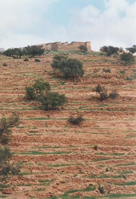
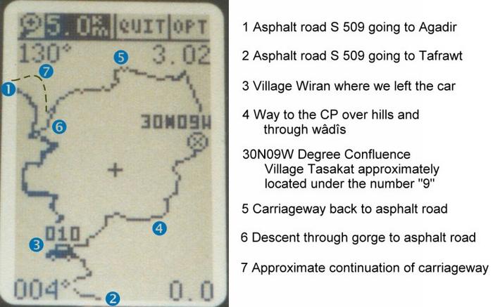
(visited by Gerhard Kaufmann, Jamila Ahejjam and `Abdu-l-Haqq Mlioui) Preface Nearly two years had passed since we last visited my wife's family in Morocco. Meanwhile we had become addicts to the Degree Confluence Project and had already discovered a new Confluence (37°N 30°E) last September in Turkey. So, when preparing our journey to Morocco, I checked the Project's web page and some roadmaps for possible Confluences within reach of our planned travels in this land. Luckily and astonishingly, until now only one Confluence had been discovered in Morocco (31°N 7°W), and so I arrived at setting ourselves the high goal of trying to discover up to SIX new Confluences in Morocco. Let's see how far we will be able to achieve this ambitious goal... 17-Apr-2002 -- After passing a few days with the family, we rented a car in Agadir and on Wednesday, 17 April we set out for the first Confluence. With great foresight of the difficulties we would meet to reach this Confluence, we decided this time to leave our little son with my wife's sister Malika to play with her three little daughters and took her husband `Abdu-l-Ḥaqq, one of my many brothers-in-law, with us. On my roadmap I could see that the Confluence 30°N 9°W is not far off the road going from Agadir in SE direction to Tafrawt, a nice little town in the picturesque scenery of the colossal granite rocks of the Anti-Atlas. So we took the road S 509 via Inzggan, Biyugra and Ayt Baha into the mountains of the Jabal Tikwayn, a promontory of the Anti-Atlas. (Remark: For the cities' and other geographical names, I won't use their usual French-style transcriptions. Instead I will use a simplified scientific transcription of their Arabic and Berber names.) The road follows the deep carved valley of the Wādiy Ayt Baha, not in the bottom of the valley, but near its eastern rim, high over the creek. Most of the time the rivers and creeks in southern Morocco are dry, but this springtime abundant rainfalls had caused many rivers and creeks to run with more or less water. With only a slight gradient, the road winds around all the ledges of the mountains and into the clefts of ravines running down into the Wādiy Ayt Baha. Observing my GPS receiver, I noticed that in one of these clefts we had the closest approach to the Confluence, being still 2.6 km away. I followed the road a little further to look for a way leading in the desired direction, but unfortunately all I could find were dry rivers full of boulders, and steeply rising rock walls that prevented even taking a look behind and towards our goal. A short distance after the closest approach we passed a small village, its houses apparently glued to the rock walls. I decided to use the paths of this village as the best way to climb up to the rim of the Wādiy Ayt Baha, which lay still nearly 100 m above the course of the road. It was now 1 o'clock p.m.; we ate our sandwiches, took a big bottle of water and all the technical gear with us, and started the hike towards the Confluence, now 3.2 km away as the crow flies, by climbing up the steep lanes of the village Wiran. Having reached the rim of the valley, we could finally take a glance in the direction of the Confluence, and found rock- and bush-covered hills and dry riverbeds in front of us, and in the distance some other villages on top of the hills. After having climbed up to this height, at first we tried to keep the height by following small trails of men and animals on the hillsides leading in the desired direction. But soon we found that hiking along and over the hills was too difficult and exhausting because the hills were covered with countless rocks and undergrowth, and the trails disappeared. So we started to climb down a steep slope to the nearest dry riverbed, which was a good decision, because from now on we made much better progress, although following the wādiys meant a little zigzagging. In the wādiys we found again trails, the ground was covered with small plants in blossom, one spot was covered with wonderfully smelling rosemary bushes. Luckily all the time, the sky was a little overcast, and so we hadn't to walk in the hot sun. After two hours and a march of nearly 3.8 km, the GPS receiver guided us to leave the wādiy and climb up a slope as we approached eventually the Confluence. From this point onward, we began also to walk between tiny terraces with barley fields. This was a sign that we were in the vicinity of one of the villages we had seen from afar, but from down in the wādiy we couldn't see it now. The barley fields here and there were interspersed with Argan trees (Argania spinosa). These trees grow only in the SW parts of Morocco, nowhere else on earth. They have a very hard wood; sometimes goats can be seen climbing to the very end of the twigs to graze on the foliage. The fruit of the trees is yellow and looks like a big olive, the countrywomen crush the kernels in hand-mills to produce a very expensive oil with delicious nut flavour, used for cooking and as a cosmetic. The last one hundred metres to the Confluence were difficult to proceed because the barley terraces now covered the whole slope, and we didn't want to step inside the small fields for respect of the cultivation and for fear of getting problems with the farmers, if they saw us. So `Abdu-l-Ḥaqq and me cautiously stepped only on the stony borders while climbing the terraces and trying to get nearer to the Confluence, whereas Jamila waited a little downward until we would have found the spot. The Confluence was finally very near; we only had to climb one more barley terrace, but what a big surprise waited for us! After two hours walking through rubble and dry rivers, we found ourselves standing on a dirt road! And the Confluence 30°N 9°W (Picture #1) lies in fact exactly in the middle of this road! This means that this Confluence, like a few others, every day is obviously passed by dozens of people unaware of it. It was now 3:15 p.m. GMT (UT + 0) and the GPS receiver (Picture #6) indicated an altitude of 1182 m and an accuracy of 6 m. Jamila climbed up to us, we still couldn't believe the presence of this carriageway, it seemed much too absurd to us. I started taking photos when some girls came along the road. They were very timid finding those strangers on their way and didn't dare to come closer. When Jamila started to talk to them in their language (Tašilḥit, the Berber language of south Morocco), they were surprised and lost a little bit their shyness. They told us that the road connects the two villages Tasakat and Adwwar Ayt Wuššn ("Village of the Jackal Clan" in Tašilḥit language) and then they squeezed past us at maximum distance and hurried away. Suddenly from the other direction a happy crowd of a dozen women in festive decorations came towards us. Again after Jamila addressed some words to them, they greeted us and gently invited us to accompany them to a marriage and to have a meal there. Of course this was an invitation you don't get every day, but we thought of our way back and sadly had to refuse, to their and our disappointment. At last, it was now a quarter to 4 p.m., three boys arrived, obviously on their way to some afternoon hours at school. We asked them about the best way back to the asphalt road, and they confirmed that the shortest way was the one that we had taken before coming from the village Wiran, but they affirmed that the carriageway would lead back to the asphalt road, too, but this way would be much longer. Nevertheless we decided to follow the dirt road, because we were reluctant to go back the same way that we had come before, and because of curiosity to see where the dirt road would meet the asphalt road. So we passed the village Tasakat (Picture #9) and went on. But the boys' hint proved right: The carriageway, not always in good condition, wound endlessly over hills and through valleys, going down and up, our feet and knees began to ache of this unaccustomed strain. I think `Abdu-l-Ḥaqq deeply regretted his rash decision to accompany us on this quest, and our only relief was the GPS receiver promisingly showing the trail of the asphalt road on its map window and our slow, slow return back towards it. When finally after more than two hours we were only some hundred metres from the asphalt road (but it still couldn't be seen, without the GPS receiver it could have been supposed as well to be still miles away), the carriageway swung back and away again from the asphalt road, climbing over another hill. Fortunately, we met three women at this point who told us that it would be still a long way following the dirt road, and instead they offered us their help by sending a boy with us who lead us down a shortcut to the road. This shortcut was in fact a very steep descent through a gorge, and when we finally saw the asphalt road beneath us, we nearly didn't want to believe our eyes. It was now 6:20 p.m., one hour later the sun would have sunk, and we had walked 9.4 km in difficult terrain since we left the car (see GPS receiver log on Picture #10). Our car was now still 2.3 km away as the crow flies, but the next car coming along the road offered me a ride (many thanks again to the helpful driver) and so I quickly got back to the village Wiran, on foot I would have had to walk another 4 km along the winding road! Last thing to do after collecting Jamila and `Abdu-l-Ḥaqq at the roadside and returning to Agadir was to look for the junction where the carriageway would meet the asphalt road. We found it at 30°0'40"N 9°2'30"W, and so I would advise a future visitor to look for this turn-off and try to get to the Confluence by following the dirt road for about 7.5 km to the village Tasakat and a little further (cross-country vehicle recommended!). Another interesting task would be to follow it southwards from the Confluence to find out if there is another possibility to return to the asphalt road in this direction. Continued at 31ºN 9ºW (First visit) |
| All pictures |
| #1: The Confluence 30°N 9°W seen from north-west. The road on which the Confluence lies is on the continuous stonewall crossing the lower third of the picture. (Confluence on the right edge of picture) #2: View towards north from Confluence. The white painted house of which a corner is visible on the picture is a very noticeable mark in the countryside from afar #3: View towards east from Confluence #4: View towards south from Confluence #5: View towards south-west from Confluence. We came through these valleys #6: GPS receiver display #7: My brother-in-law and me at the Confluence #8: Graffito left on a roadside stone #9: The village Tasakat with typical stone houses a few hundred metres north of the Confluence #10: Our way through the mountains logged on the GPS map ALL: All pictures on one page |