|

France : Hauts-de-France
3.0 km (1.9 miles) NE of Les Hemmes, Pas-de-Calais, Hauts-de-France, France
Approx. altitude: 0 m
(0 ft)
([?] maps: Google MapQuest OpenStreetMap ConfluenceNavigator)
Antipode: 51°S 178°W
Accuracy: 80 m (262 ft)
Quality: good
Click on any of the images for the full-sized picture.


![]()


| 51°N 2°E (visit #2) | (secondary) |
![Visit #18: [13-Sep-23]](/fr/all/n51e002v18/preview.jpg "Visit #18: [13-Sep-23]")
![Visit #17: [03-Sep-19]](/fr/all/n51e002v17/preview.jpg "Visit #17: [03-Sep-19]")
![Visit #16: [27-Jan-19]](/fr/all/n51e002v16/preview.jpg "Visit #16: [27-Jan-19]")
![Visit #15: [25-Aug-15]](/fr/all/n51e002v15/preview.jpg "Visit #15: [25-Aug-15]")
![Visit #14: [28-Sep-14]](/fr/all/n51e002v14/preview.jpg "Visit #14: [28-Sep-14]")
![Visit #13: [09-Mar-13]](/fr/all/n51e002v13/preview.jpg "Visit #13: [09-Mar-13]")
![Visit #12: [22-Nov-12]](/fr/all/n51e002v12/preview.jpg "Visit #12: [22-Nov-12]")
![Visit #11: [04-Sep-10]](/fr/all/n51e002v11/preview.jpg "Visit #11: [04-Sep-10]")
![Visit #10: [20-Apr-10]](/fr/all/n51e002v10/preview.jpg "Visit #10: [20-Apr-10]")
![Visit #9: [22-Jan-10]](/fr/all/n51e002v9/preview.jpg "Visit #9: [22-Jan-10]")
![Visit #8: [07-Sep-09]](/fr/all/n51e002v8/preview.jpg "Visit #8: [07-Sep-09]")
![Visit #7: [25-Jul-09]](/fr/all/n51e002v7/preview.jpg "Visit #7: [25-Jul-09]")
![Visit #6: [24-Jan-09]](/fr/all/n51e002v6/preview.jpg "Visit #6: [24-Jan-09]")
![Visit #5: [01-Jan-09]](/fr/all/n51e002v5/preview.jpg "Visit #5: [01-Jan-09]")
![Visit #4: [27-Aug-07]](/fr/all/n51e002v4/preview.jpg "Visit #4: [27-Aug-07]")
![Visit #3: [10-Aug-07]](/fr/all/n51e002v3/preview.jpg "Visit #3: [10-Aug-07]")
![Visit #1: [18-Jan-02]](/fr/all/n51e002/preview.jpg "Visit #1: [18-Jan-02]")
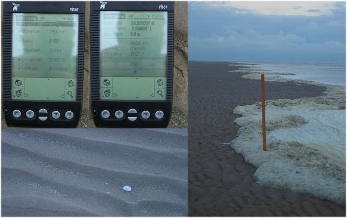
 (visited by Hans Augdoppler) 04-May-2002 -- After crossing the channel by ferry during the very early morning a rest on the beach was necessary. And where, of course, close to a CP, in the village ‘LES HEMMES DE MARCK’ a beach named “Plage des Hemmes”. Just after sunrise I walked down of the dunes across the tideland. Awaiting the oncoming high tide I came as close as ~80m without wet feet. Since this is the ‘Strait of Dover’ you see ferries frequently.
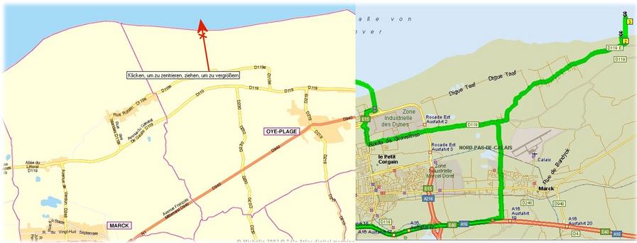
Right map in pic#9 © MapPoint Europe http://www.microsoft.com; For more information see: http://linz.orf.at/gast/augdoppl/Confluence/Main.htm |
| All pictures |
| #1: Closest, dry place to confluence marked with stick - view to NORTH #2: Village ‘LES HEMMES DE MARCK’ acces to beach “Plage des Hemmes” #3: Parking & dunes at “Plage des Hemmes” #4: Seashore to SOUTH with GPS reading #5: View to NE - DUNKERQUE #6: View to SW - CALAIS #7: Dunes back in direction SE #8: Beach access trough the dunes from “Plage des Hemmes” #9: Maps ALL: All pictures on one page |
| Notes |
|
About 600 m off the French coast in the English Channel. |