|

United Kingdom : England
3.8 km (2.4 miles) ESE of Rylstone, North Yorkshire, England, United Kingdom
Approx. altitude: 401 m
(1315 ft)
([?] maps: Google MapQuest OpenStreetMap ConfluenceNavigator)
Antipode: 54°S 178°E
Accuracy: 4 m (13 ft)
Quality: good
Click on any of the images for the full-sized picture.

![]()


![]()
| 54°N 2°W (visit #2) | (secondary) |
![Visit #18: [24-Dec-19]](/uk/en/n54w002v18/preview.jpg "Visit #18: [24-Dec-19]")
![Visit #17: [28-Apr-18]](/uk/en/n54w002v17/preview.jpg "Visit #17: [28-Apr-18]")
![Visit #16: [26-Apr-12]](/uk/en/n54w002v16/preview.jpg "Visit #16: [26-Apr-12]")
![Visit #15: [16-Apr-12]](/uk/en/n54w002v15/preview.jpg "Visit #15: [16-Apr-12]")
![Visit #13: [16-Mar-12]](/uk/en/n54w002v13/preview.jpg "Visit #13: [16-Mar-12]")
![Visit #14: [09-Mar-12]](/uk/en/n54w002v14/preview.jpg "Visit #14: [09-Mar-12]")
![Visit #12: [03-Aug-11]](/uk/en/n54w002v12/preview.jpg "Visit #12: [03-Aug-11]")
![Visit #11: [04-Jun-10]](/uk/en/n54w002v11/preview.jpg "Visit #11: [04-Jun-10]")
![Visit #10: [29-May-09]](/uk/en/n54w002v10/preview.jpg "Visit #10: [29-May-09]")
![Visit #9: [29-May-09]](/uk/en/n54w002v9/preview.jpg "Visit #9: [29-May-09]")
![Visit #8: [13-Jan-09]](/uk/en/n54w002v8/preview.jpg "Visit #8: [13-Jan-09]")
![Visit #7: [14-Jul-08]](/uk/en/n54w002v7/preview.jpg "Visit #7: [14-Jul-08]")
![Visit #5: [08-Jun-04]](/uk/en/n54w002v5/preview.jpg "Visit #5: [08-Jun-04]")
![Visit #6: [08-Jun-04]](/uk/en/n54w002v6/preview.jpg "Visit #6: [08-Jun-04]")
![Visit #4: [07-Jan-04]](/uk/en/n54w002v4/preview.jpg "Visit #4: [07-Jan-04]")
![Visit #3: [18-Jun-02]](/uk/en/n54w002v3/preview.jpg "Visit #3: [18-Jun-02]")
![Visit #1: [14-Jun-00]](/uk/en/n54w002/preview.jpg "Visit #1: [14-Jun-00]")
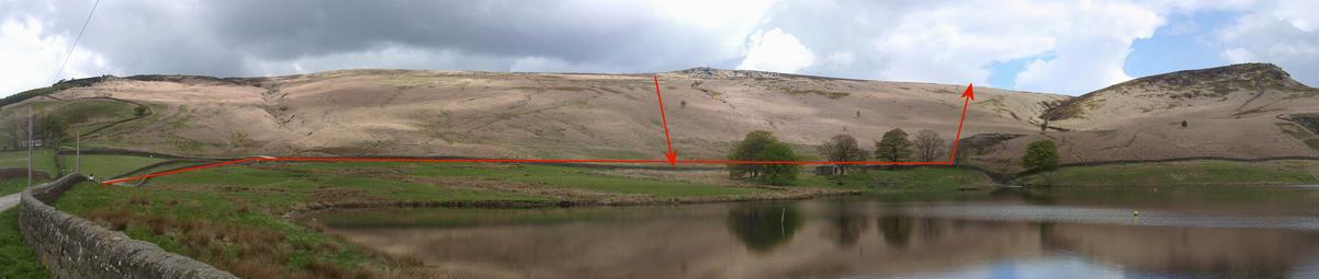
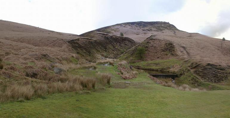
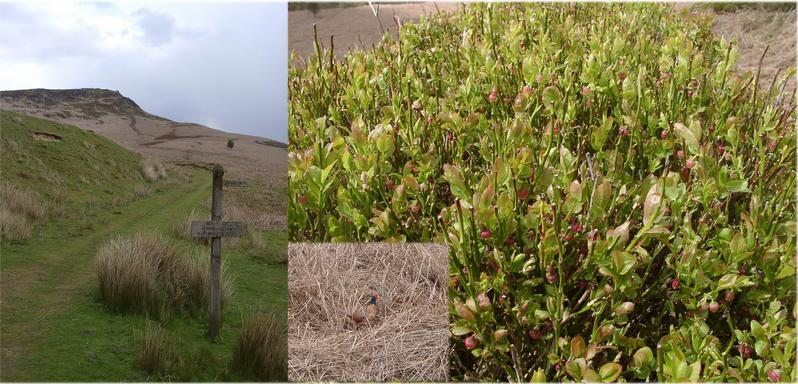
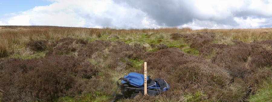
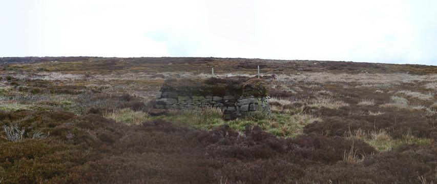
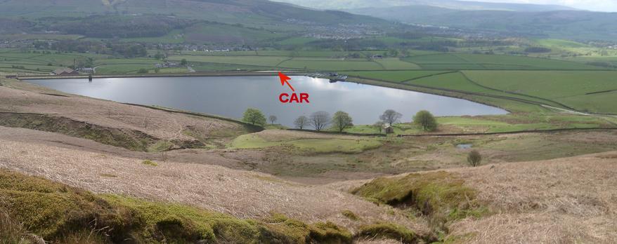
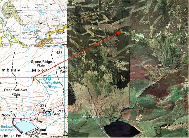
 (visited by Hans Augdoppler) 03-May-2002 -- After a nightmare passing the city of Bradford (road works everywhere) I reached the village of Embsay. The public car park (53,9858°N 2,0036°W) at the Embsay Reservoir is a meeting point for dogs and their owners. Facing the southern boundary Yorkshire Dales National Park with the Embsay Crag I asked two gentlemen for some advice. As I knew from visitor#1 there supposed to be an "easy" path – but where is it – no idea. Since the GPS directed me towards NORTH therefore the crag was not my favourite. So I walked around the lake and tried find a path uphill. Before I reached the brook which drains the bog I turned left following the GPS indication. For me this was strange vegetation with a lot of birds and walking on a sponge. After I had crossed the hill walked down directly in well-head of the ‘Wayshaw Bogs’. It does not look swampy, but my boots were already filled up. For the way back I went westwards hoping to find a suit path. After all I found something that could be called so and it connected strange semicircle stone walls in regular intervals. Somehow the path disappeared again and I stepped down with some more water in my boots. Nevertheless I enjoyed the tremendous view to the SOUTH. As I study the maps and aerial photo again I suspect that there should be a path directly from north western corner of the reservoir. Try it, it’s a nice hike and wear watertight boots.
Maps in pic#8 was provided by http://www.streetmap.co.uk; For more information see: http://linz.orf.at/gast/augdoppl/Confluence/Main.htm |
| All pictures |
| #1: Confluence - view to NORTH #2: Parking lot & helpful gentlemen & NP-sign #3: To NORTH – routes up and down #4: Brook with way up in detail (NE #5: Track, plants & bird #6: Swamp & remaining of a bird #7: Semicircle stone walls #8: Maps & aerial photo #9: View to SOUTH - Embsay Reservoir & village #10: Panoramic view from confluence to NORTH/EAST ALL: All pictures on one page |
| Notes |
|
In the Yorkshire Dales National Park. |