|

Brazil : Rio de Janeiro
Ilha do Cabo Frio (Island), Rio de Janeiro, Brazil
Approx. altitude: 123 m
(403 ft)
([?] maps: Google MapQuest OpenStreetMap ConfluenceNavigator)
Antipode: 23°N 138°E
Accuracy: 3.3 km (2.0 mi)
Quality: good
Click on any of the images for the full-sized picture.


| 23°S 42°W (visit #2) | (incomplete) |
![Visit #3: [25-Mar-04]](/br/all/s23w042v3/preview.jpg "Visit #3: [25-Mar-04]")
![Visit #1: [02-Mar-01]](/br/all/s23w042/preview.jpg "Visit #1: [02-Mar-01]")

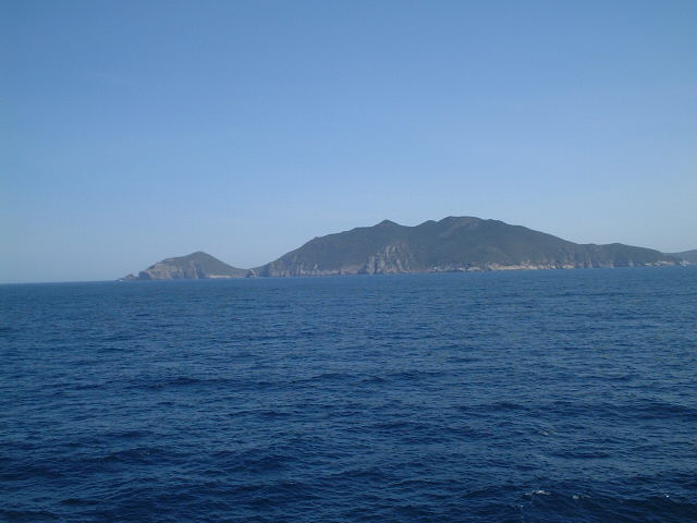
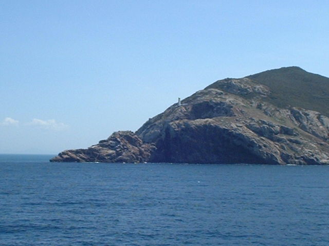
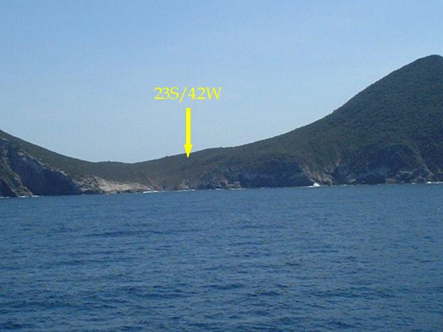
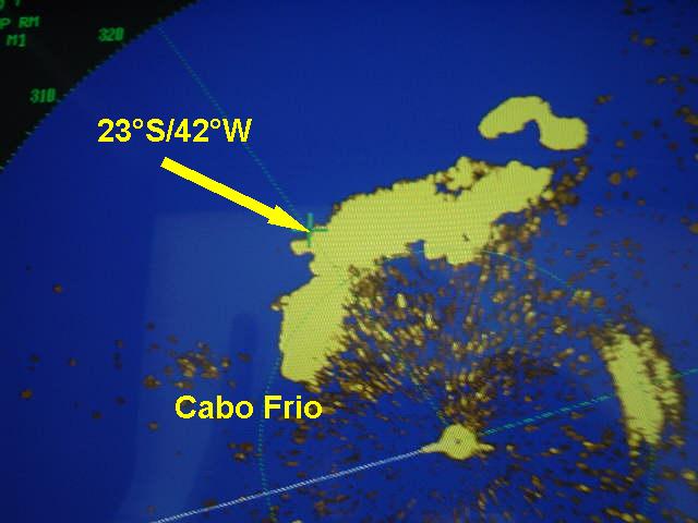
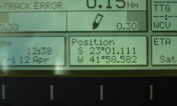
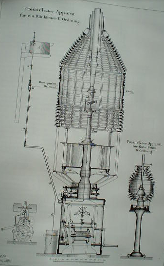
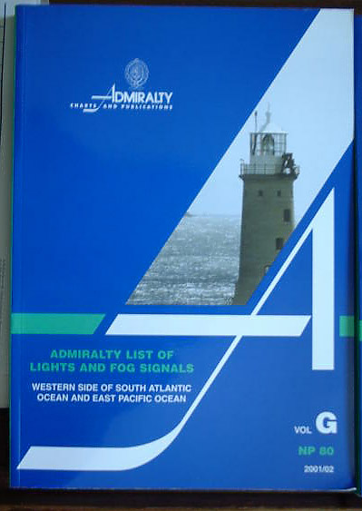
(visited by Captain Peter, Volodymyr Sydorenko, Volodymyr Kokorev and Valentyn Smirnov) 12-Apr-2002 -- After having loaded at San Antonio on 07-Apr-2002, we began our voyage with our Argentine lemons, apples, pears and grapes to Saint Petersburg, Russia, 8,000 nautical miles nonstop. Especially the beginning of a trip from South America to Europe is always bothersome. Due to the strong Brazil current setting against, you are creeping with reduced speed for several days along the coast of Brazil and the trip seems indeed to be endless. In order not to die of boredom during such a voyage, we decided to see some confluences en route. With the first one, on 23°S / 42°W, it was clear from the very beginning it could remain only an attempt for us, as it is on land and not reachable by ship. But as this point has been already successfully visited, it's not as bad as all that. The only thing we could do is to pass the Island of Cabo Frio in a safe distance and make a picture of it. The south-westernmost tip of the island itself is called Cabo Frio (the "Cold Cape"). There is a conspicuous lighthouse on it. The confluence is 140 m above sea level and almost exactly on top of the ridge connecting the two highest elevations of the island (390 m in the East and 250 m in the South-West). In order to identify the point with maximum accuracy first we adjusted it in the radar and then Captain Peter found its correct direction ("azimuth", as the navigators use to say) by a gyro compass bearing. Probably the confluence is not visible from the ship, but just a little bit over the ridge toward NE. Our GPS shows a closest position of 23°01,111'S and 41°58,582W, i.e. a 3,300 metres off the confluence at 12:38hrs, but that being not of significance under the prevailing circumstances, as there was anyway no chance for us to go to the point, due to the beforementioned reasons. Ilha do Cabo Frio is separated from the mainland by a very narrow passage, only 135 m wide, called Boqueirão. It is spanned by an overhead cable. The closest town is Arraial do Cabo, a fishing and salt loading port. The hinterland is full of salt pans. See the chequered areas on the chart. The lighthouse on Cabo Frio gives us the opportunity to think about lighthouses in general. Lighthouses are not just simple candles, they are rather complicated and have a long history: Already in ancient times experiments with lighthouses took place. But their brightness was frequently left to the chance. Unprotected open fires on towers were flickering irregularly, sometimes brighter, sometimes darker. In 1765 an 18 year old French, Antoine Laurent Lavoisier, discovers that a source of light in the focus of a parabolic mirror is reflecting all rays parallelly. That is the basis of all modern lights, from the brightest floodlight over the cars' headlights to the smallest torchlight. In 1822 another French, Augustin Fresnel, constructs the first lens named after him. This lens is focussing the beams of the light as a parabolic mirror, but is concentrating it additionally in the horizontal direction. Fresnel developed a lens formed like a collection of belts, grinded horizontally and not perfectly circular. Several of these horizontal grindings added together are focussing the light of a single source parallel to the surface of the sea. Now no light could go lost any longer. With the Fresnel-Lens France established a powerful position. They had the monopoly for its production. Whoever was in need of safe lighthouses had to purchase them in France. After the victory of Germany over France in 1871 the French had to deliver Fresnel-Lenses as war-reparations to Germany. This fact underlines the importance of these lenses. Lighthouses with a high range are a beautiful thing. But soon, after the middle of the 19th century, there are so many lighthouses along the coast of Europe that it becomes difficult to distinguish them. This problem has been solved by different colors and codes. Lightouses were then blinking and flashing with different interruptions. Cabo Frio lighthouse for example has a code of "Fl.10s144m49M" This means: A white flash every 10 seconds. The height of the light is 144m above sea level, and the reach or visibility of the light is 49 n. miles (90,7 km). It is an extremely strong light. The source of the light changed as well. In 1885, an Austrian, Auer von Welsbach, invented the glowing stocking. With a gas-air-mixture he makes a silk stocking to glow. But then electrification takes place. The first electrically powered lighthouse was built in France in 1865, on Cap de la Hève, near Le Havre, on the entrance of River Seine. All light houses of the World are listed in the "Admiralty List of Lights and Fog signals" of the British Admiralty.
--------------------------------------------- |
| All pictures |
| #1: The Confluence Point #2: Map of the Confluence Point #3: Ilha do Cabo Frio seen from North-East #4: Cabo Frio #5: Radar #6: Captain Peter taking a compass bearing from the point #7: GPS #8: Salt pans are shown chequered #9: drawing of the Fresnel-Lens used in lighthouses #10: Admiralty List of Lights and Fog signals ALL: All pictures on one page |