|

United Kingdom : England
2.1 km (1.3 miles) NNW of Aydon, Northumberland, England, United Kingdom
Approx. altitude: 126 m
(413 ft)
([?] maps: Google MapQuest OpenStreetMap ConfluenceNavigator)
Antipode: 55°S 178°E
Accuracy: 5 m (16 ft)
Quality: good
Click on any of the images for the full-sized picture.


| 55°N 2°W (visit #2) | (secondary) |
![Visit #20: [06-Sep-19]](/uk/en/n55w002v20/preview.jpg "Visit #20: [06-Sep-19]")
![Visit #18: [13-Mar-14]](/uk/en/n55w002v18/preview.jpg "Visit #18: [13-Mar-14]")
![Visit #17: [08-Oct-11]](/uk/en/n55w002v17/preview.jpg "Visit #17: [08-Oct-11]")
![Visit #15: [06-Sep-10]](/uk/en/n55w002v15/preview.jpg "Visit #15: [06-Sep-10]")
![Visit #14: [16-Apr-10]](/uk/en/n55w002v14/preview.jpg "Visit #14: [16-Apr-10]")
![Visit #13: [21-May-09]](/uk/en/n55w002v13/preview.jpg "Visit #13: [21-May-09]")
![Visit #12: [13-Jan-09]](/uk/en/n55w002v12/preview.jpg "Visit #12: [13-Jan-09]")
![Visit #11: [01-Dec-08]](/uk/en/n55w002v11/preview.jpg "Visit #11: [01-Dec-08]")
![Visit #9: [08-Jun-08]](/uk/en/n55w002v9/preview.jpg "Visit #9: [08-Jun-08]")
![Visit #8: [22-May-08]](/uk/en/n55w002v8/preview.jpg "Visit #8: [22-May-08]")
![Visit #7: [24-Jun-06]](/uk/en/n55w002v7/preview.jpg "Visit #7: [24-Jun-06]")
![Visit #6: [19-Mar-05]](/uk/en/n55w002v6/preview.jpg "Visit #6: [19-Mar-05]")
![Visit #5: [11-Jun-04]](/uk/en/n55w002v5/preview.jpg "Visit #5: [11-Jun-04]")
![Visit #4: [09-Jun-04]](/uk/en/n55w002v4/preview.jpg "Visit #4: [09-Jun-04]")
![Visit #3: [11-Oct-02]](/uk/en/n55w002v3/preview.jpg "Visit #3: [11-Oct-02]")
![Visit #1: [07-Jan-01]](/uk/en/n55w002/preview.jpg "Visit #1: [07-Jan-01]")
![Visit #19: [03-Jan-20]](/uk/en/n55w002v19/preview.jpg "Visit #19: [03-Jan-20]")
![Visit #16: [02-Aug-11]](/uk/en/n55w002v16/preview.jpg "Visit #16: [02-Aug-11]")
![Visit #10: [13-Jul-08]](/uk/en/n55w002v10/preview.jpg "Visit #10: [13-Jul-08]")

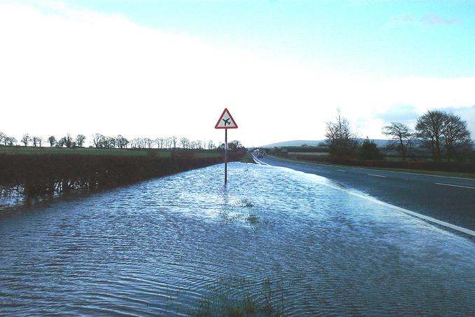
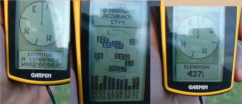
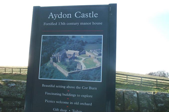
(visited by Gordon Spence) 26-Feb-2002 -- With another success under the belt (55N 4W), it is straight across country, back into England and on towards 55N 2W. Shortly after passing back into England, I passed what is known as Carlisle Airport - as a seasoned traveller I would say that calling it a "municipal" airport would be generous, just fields really, but the runway I could see was paved. Anyhow as you can see from (Pic 3), they get some very low "swimming" aircraft! It was a very nice scenic run through the border regions of England, I passed numerous turn-offs that were signed "Hadrian's Wall", for those that don't know what this is, it was built by the Romans to keep the "Barbarians" out! If you want to know more, this http://www.hadrians-wall.org/ is a good starting point. At one point while passing through a small town/large village I had to cross over the River South Tyne. There has been a lot of rain here recently and the river was well up. (Pic 4) shows the view from the road and (Pic 5) the view from the bridge. I don't fancy living in the cottage with the two parked cars - might get a bit wet... I could see from the map that it was to the North of the main route, but I must have missed the unsigned or poorly signed turn-off. I found myself at a major inter-section and looped back around to the South. After a couple of miles I came to an unmarked, single track road. This snaked around for another couple of miles. At the next junction, a right followed by immediate left, into an even narrower single track road - signposted to Aydon Castle. This track was flooded in several places, at one point to nearly six inches - I was in an ordinary saloon car. I followed the GPS bearing readings taking what appeared to be a drive-way, but was shown on the map as a road. This took me to within 400 feet of the confluence point. The field was fenced, there were no keep out signs, no nearby buildings and the field was grassed. I hopped over the fence and in two minutes I was there (Pic 2). Looking to the North you can see my car (Pic 1) and the aforementioned castle. It may be worth going back later in the year when it is open, after all it is around 800 years old (Pic 6). Time to head home, I left at 4am this morning....arriving back at 9pm after 693 miles. |
| All pictures |
| #1: Looking North #2: GPS montage #3: Low Swimming Planes! #4: River South Tyne in flood #5: That cottage might get a bit wet.... #6: Aydon Castle ALL: All pictures on one page |