|

Turkey
2.1 km (1.3 miles) SW of Derbent, Konya, Turkey
Approx. altitude: 1572 m
(5157 ft)
([?] maps: Google MapQuest OpenStreetMap ConfluenceNavigator)
Antipode: 38°S 148°W
Accuracy: 4 m (13 ft)
Quality: good
Click on any of the images for the full-sized picture.


| 38°N 32°E (visit #1) |
![Visit #3: [12-Oct-07]](/tr/all/n38e032v3/preview.jpg "Visit #3: [12-Oct-07]")
![Visit #2: [26-Mar-06]](/tr/all/n38e032v2/preview.jpg "Visit #2: [26-Mar-06]")

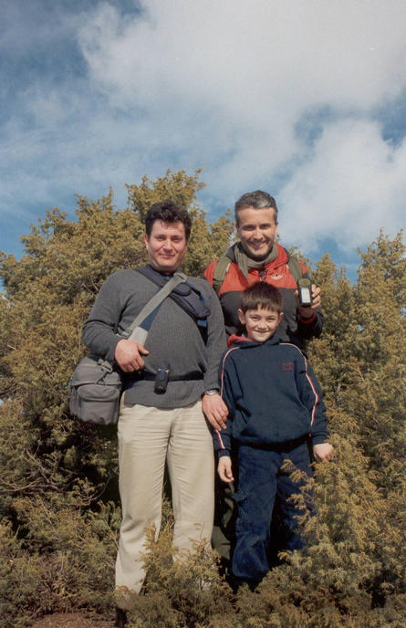
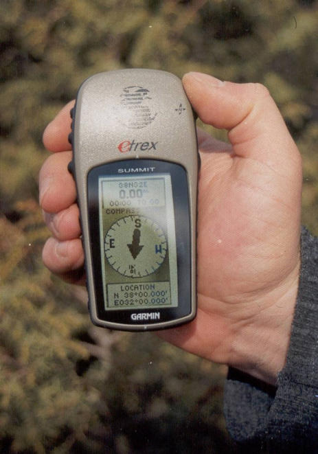
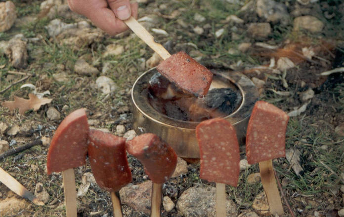
(visited by Berkant Atay, Güven Kaya, Murat Faydalıgil and Orçun Faydalıgil) 26-Jan-2002 -- Though we had thought we could go and find the 38N 32E Confluence earlier, the weather here did not permit an outdoor experience of this kind. It snowed for days, after which everything froze and time seemed to stop. This week was not as harsh as the last ones, so we decided to make our first confluence hunt. Saturday was the appointed day. The team consisted of an ENT surgeon, Murat, and his ten year-old son Orçun, Berkant, who is a neurosurgeon, and Maj. Güven, a commando leader now preparing for his retirement. We set out at 11:00 from Beyşehir, where we live, and took D330 highway towards Konya. After driving about 25 km, we turned left and headed towards Derbent village which is only a few km’s away from the Confluence. The maps provided by Mapquest helped a lot. As we approached the Confluence, the GPS readings showed that a hill of a few hundred meters height was to be climbed. We looked desperately around to see another path, since the ground was wet and slippery from melting snow. But unfortunately the only thing we could do was to directly follow the GPS guidance. After climbing approximately a hundred meters or so in a moderate tempo, we recognized a bovine smell, alarming us that there could be watch dogs around. Since hunting of any kind (except for Confluences) is prohibited for a few months in Turkey, which is a very appropriate measure taken by the government, we did not carry any guns for protection. So we changed the course to the right. The climbing got tough as we climbed further because of the snow. We took a break under a beautiful pine tree. The major suggested that if we faced downhill we could get more rest, after which we exactly felt the effect soon. We happened to see some footprints of an animal, over which we argued that they could belong to a large feline body. We sadly wished it to be true, because the large wild cats are so rare now in Turkey. We reached the summit and happily saw that the last 500 meters to the Confluence was a prairie with a nice sight of view. The hastened steps took us almost immediately to the spot. After a brief confluence dance, we achieved to make the GPS receiver show 0.00 meters to go to reach 38N 32E. The 1587 m altitude reading was only 1 meter higher than the confluence.org’s information. The land was flat and a small bush seemed having chosen its residence just on the Confluence. The clear weather enabled us to see kilometers of the landscape in four directions. We took pictures and took the way back. The descent was uneventful except for the snow, leaking in our shoes and freezing the toes. We drove back to town. But on the way back, we pulled near a small water spring and had our sausages. Although this was our first Confluence and surely it was not a piece-of-cake one, we had so much fun today. We are looking forward to go for another one soon. |
| All pictures |
| #1: South #2: West #3: North #4: East #5: eTrex Summit on the spot #6: The team #7: Standing #8: Barbecue ALL: All pictures on one page |