|

Portugal
4.0 km (2.5 miles) SSE of Selvagem Pequeña (Island), Ilhas Selvagens, Madeira, Portugal
Approx. altitude: 0 m
(0 ft)
([?] maps: Google MapQuest OpenStreetMap ConfluenceNavigator)
Antipode: 30°S 164°E
Accuracy: 14 m (45 ft)
Quality: good
Click on any of the images for the full-sized picture.


| 30°N 16°W |

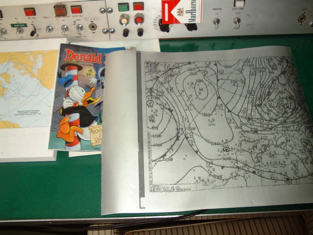
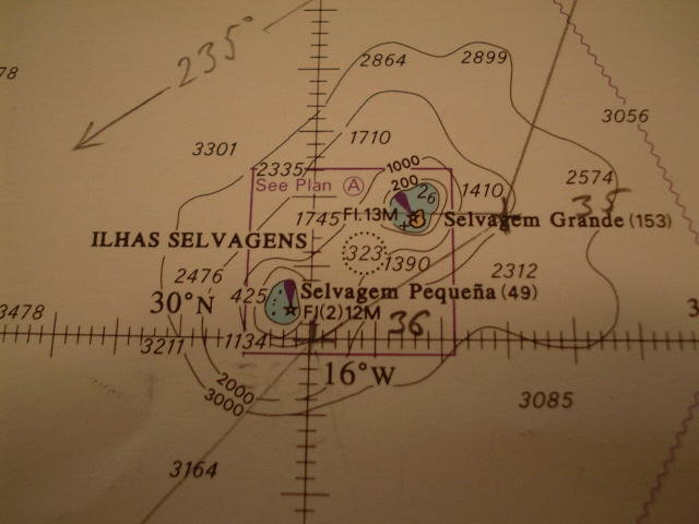
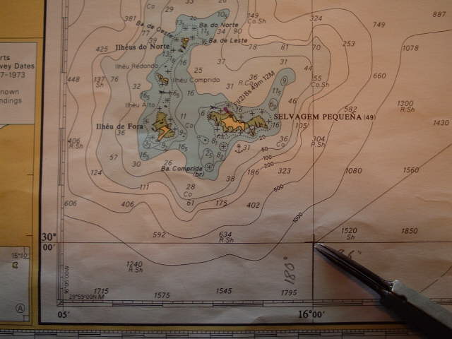
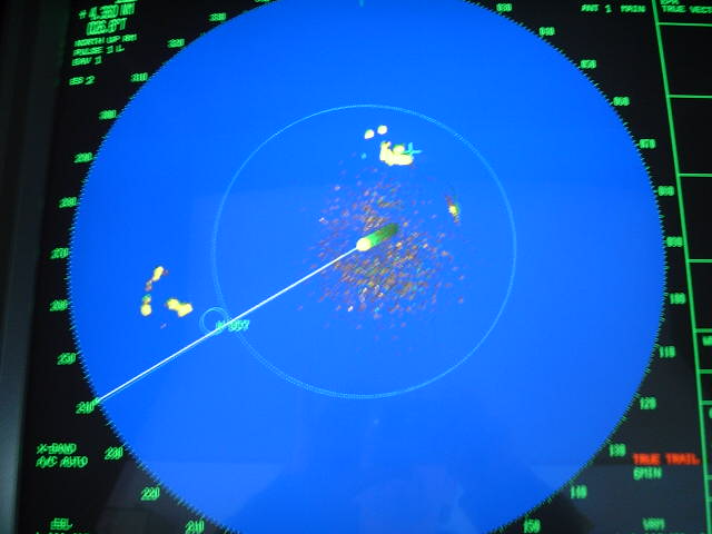
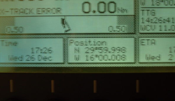
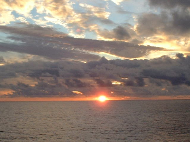
(visited by Captain Peter, Valentyn Smirnov and Volodymyr Kokorev) 26-Dec-2001 -- After completion of loading a cargo of 5,000 tons frozen fish for the Côte d'Ivoire (Ivory Coast, but according to a presidential decree the country's name must not be translated!), and Nigeria in Bremerhaven (Germany) and Ijmuiden (Netherlands), we left Ijmuiden on 21 December 2001 in the evening, transited the Dover Strait (Pas de Calais), the English Channel (La Manche) and the Bay of Biscay (Baie de Gascogne, Bahia de Vizcaya) in rather fine weather for this season. One of Captain Peter's duties is to take the weather chart every day, with a 20-year old Japanese shortwave Fax-receiver. From Cabo Finisterre, the NW tip of Spain, the course to Cape Verde, the westernmost tip of Africa, passes through the Canary Islands, but before arriving there it passes a tiny group of islands of volcanic origin, the Ilhas Selvagens (the "Savage Islands"), a 160 nautical miles (300 km/185 statute miles) SSE of Madeira. Madeira and Ilhas Selvagens were discovered by a Portuguese in the 15th century, at which time they were all uninhabited. Since then, with the exception of a period of Spanish domination between 1581 and 1640, and also of temporary occupation of Madeira by British troops in the early part of the 19th century, the group has been under Portuguese Sovereignty. The Ilhas Selvagens (singular: Ilha Selvagem) are two small but distinct groups of islands and rocks separated by a channel with considerable depth and 8.5 nautical miles wide. The Northern group is composed of Ilha Selvagem Grande (Great Savage Island) and two off-lying rocky islets, Palheiro de Terra and Palheiro do Mar. Ilha Selvagem Grande is uninhabited except for two wardens. The lighthouse today is working automatically. The islands, previously privately owned, have been purchased by the Portuguese Government in 1971 and are a protected bird sanctuary. Shearwater seabirds are breeding on the islands. A specially protected area, surrounding Ilhas Selvagens extends from the shore to the 200 m depth contour. Navigation in this area is prohibited for big ocean going ships like mine. With a fax-permission from Parque Natural da Madeira it is possible to visit the Island with a warden. The Southern group consists of two islands, Ilha Selvagem Pequeña (Small Savage Island) and Ilhéu de Fora together with several rocky islets and reefs. Fortunately the Confluence lies just outside of the nature reserve, about 2.5 nautical miles (4.9 km, 2.9 statute miles) SE of Ilha Selvagem Pequeña in deep water of about 1,500 metres (810 fathoms/4,900 ft). Ilha Selvagem Pequeña is uninhabited. In the past it was visited during the months of July and August by fishermen from the Canary Islands, but this is no longer possible. Since the early nineties there are also wardens inhabiting here for some months and it is forbidden to fish comercially. It has a low rocky coast faced in many parts by steep beaches of pebbles. The island is for the most part otherwise sandy, undulating and slightly covered with vegetation. The average elevation of the island is between 11 m and 14 m, but at the north end lies Pico do Veado, 49 m (161 ft) high, abrupt and conical. At 15:00 hrs Ilha Selvagem Grande appeared on the Radar Screen at a distance of 20 nautical miles. Somebody began quacking on the VHF, but, though I am able to understand Portuguese, we did not understand a single word. Probably the wardens did talk to each other in a Portuguese dialect or were talking about a topic not familiar to me. We passed Ilha Selvagem Grande and then proceeded SW to the meridian of 16°W, as can be seen beautifully on the radar screen. "On top" of the screen (or Starboard aft - as we use to say) is Selvagem Grande, and "left" (seen from the ship on Starboard forward) is Selvagem Pequeña to whom we were heading now. When we hit the 16°-meridian about 2 nautical miles N of the Confluence, we followed it exactly South, and at 17:26 hrs the ship was almost exactly on the Confluence, exactly a 13.5 meters (44 ft) too much in the SW - according to the very accurate Differential-GPS. See Ilha Selvagem Pequeña and its adjacent rocky islets, reefs and Pico do Veado Mountain from the Confluence, as we did this remarkable day, when we could bring this rather unknown and tiny archipelago to the kind attention of the World, being today a candidate to World Heritage from the UNESCO. At sunset we said "good-bye Ilhas Selvagens" and continued on our course to Abidjan. By the way, did you know that the parallel 30°N is the one having the longest share in land compared with all the others? ----------------------- |
| All pictures |
| #1: Selvagem Pequeña from the Confluence #2: Captain Peter receiving the weather-chart #3: The finished product: Weather-chart from Offenbach/Germany, station DDK #4: The Ilhas Selvagens #5: Note on nautical chart regarding nature reserve #6: Map of the Southern group of islands #7: Ilha Selvagem Grande #8: Radar screen, heading toward Selvagem Pequeña #9: Readout from differential GPS #10: Good-bye Ilhas Selvagens ALL: All pictures on one page |
| Notes |
|
At sea, you find a small island |