|

Namibia : Erongo
46.5 km (28.9 miles) N of Arandis, Erongo, Namibia
Approx. altitude: 867 m
(2844 ft)
([?] maps: Google MapQuest OpenStreetMap ConfluenceNavigator)
Antipode: 22°N 165°W
Accuracy: 6 m (19 ft)
Quality: more pictures needed
Click on any of the images for the full-sized picture.


")
| 22°S 15°E (visit #1) |
![Visit #4: [25-Apr-21]](/na/all/s22e015v4/preview.jpg "Visit #4: [25-Apr-21]")
![Visit #3: [29-Jul-06]](/na/all/s22e015v3/preview.jpg "Visit #3: [29-Jul-06]")
![Visit #2: [03-Jul-03]](/na/all/s22e015v2/preview.jpg "Visit #2: [03-Jul-03]")

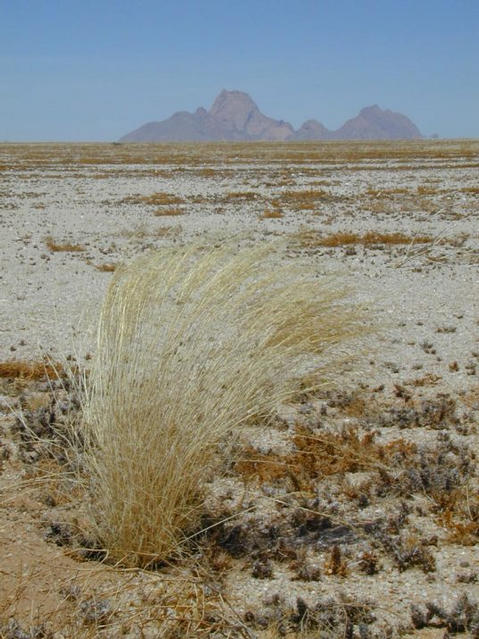
(visited by Udo Kleyenstüber and Agnes Kleyenstüber) 23-Dec-2001 -- The confluence of latitude 22°S and longitude 15°E is situated in the middle of the Namib desert, an up to 140 km wide barren strip stretching from south to north along the entire Namibia coastline. In spite of annual rainfalls well below most other deserts in the world, it boasts of an amazing variety of fauna and flora due to humidity carried inland by frequent mist rolling in from the cold Benguela ocean current. The Namib (one of the oldest deserts in the world) is thus a relatively "cool" desert. On 23 December we were lucky to experience a cool sea breeze and in spite of summer and having the sun right above us it was real pleasure to search for the Confluence. A little 4x4 track took us to within 3 km of the Confluence. We left the track and headed straight across gravel plains towards our goal. We had hoped that the Confluence would not be situated inside a dry riverbed, but it did. The little stone cairn we erected will thus not last forever. The landscape in this specific area is totally barren and the only outcrops visible from the Confluence are the huge plutonic granite plugs of the "Klein" and "Gross Spitzkuppe" about 26 km away. In spite of (or perhaps because of) all the barrenness, the area creates a sense of freedom and somehow one feels attracted to the desert time and again. |
| All pictures |
| #1: General view towards north-east #2: GPS #3: Standing on top of the Confluence #4: View towards the Gross Spitzkuppe (also called the "Matterhorn of Namibia") ALL: All pictures on one page |