10-Nov-2001 -- After our exhausting
confluence hunt in southeastern Kentucky
, We decided to make our next geek trip a little closer to home. 39° North,
84° West is only a one hour drive to the southeast and looked to be fairly
easy to get to (read: not on a 100% grade hill). The weather couldn't have
been more perfect; sunny and around 55 degrees.
Dave showed up at my (Rich's) house shortly after 11:00 am. Dave had recently
acquired a brand new IBM ThinkPad with 1600x1200 resolution and had it loaded
with Delorme Street Atlas. Technical difficulties began immediately. Dave
had trouble getting the Delorme software to talk to his Garmin eTrex GPS.
Equipment triage was performed on the deck outside Rich's duplex. Some RTFM
and a few choice four letter words later, the eTrex and the laptop were finally
on speaking terms.
We hit the road at about 11:40 am ... and promptly turned back to retrieve
Rich's Palm V Delorme Earthmate adapter cable ... *sigh*. Finally, we hit
the road for real a few minutes before noon. Fortunately, it was a short
drive.
More technical difficulties: The mapping software is supposed to have ?voice
navigation?. So far it hadn't said a word. A little more RTFM and a well
hidden check box got us a computerized female voice. This played over Dave's
car radio via a cassette adapter.
Our route took us first east then south on I-275 (Cincinnati's beltway).
Turning east again, we exited onto Route 32. After passing the Eastgate Mall,
the terrain quickly faded into typical Ohio farm country. Nice drive on a
sunny day. We had driven on Route 32 for about 20 miles when the laptop piped
up telling us to turn right on to Route 276. Another glitch. There is no
exit for Route 276 from Route 32 (unless you want to drive off a bridge).
The next exit was 3/4 of a mile away and got us on to Route 133 heading south.
Our fortunes took a turn back in a somewhat positive direction when, within
a mile, Route 133 and Route 276 merged into one and we were back on track.
The back roads of Ohio are rather scenic this time of year and we passed
several houses with leaf fires burning in the back yard. As we made lefts
and rights onto roads with increasingly longer names, the laptop told us
our goal was close at hand. Our last right was a southbound turn onto Locust
Ridge New Harmony Road. From our research, we determined that this would
be the best approach even though it was just shy of 850 meters west of the
confluence. We could have stopped along Kress Road and been within 300 meters,
but, looking at the aerial photo, we couldn't see any buildings of possible
landowners near the site. At around 1:30 pm, we pulled into the driveway
of a farmhouse directly west of the confluence.
Dave brought the car to a stop in front of an out-building at the end of
the driveway. We exited the car and were greeted by young man astride a motorcycle.
We explained our motives for being there and presented him with the letter
from the Confluence Project. He understood what we were seeking, but was
unaware of the Confluence Project. The man's name was Dan Blevins and he
gave us permission to cross the cornfield to access the confluence. He said
he had been back there several times and offered to show us the way. We accepted.
Now a team of three, we crossed south-southeast across the back yard of the
farmhouse to an unpainted gate constructed of pressure-treated lumber. Beyond
the gate was a wide mud track used by farm equipment to access the cornfield.
The track was well used and had several foot deep tire tracks running through
it. A few of the tracks contained some shallow water, but it was mostly dry
and easily traversable. We made our way across the track to the southwest
corner of the cornfield.
There was a path covered with field grass at this corner of the cornfield
that followed the tree line. Mr. Blevins explained that the path is usually
maintained, but had been neglected as of late. The grass was ankle deep with
some sparse hip high brush. As we made our way along the southern edge of
the cornfield, the sparse brush thickened a bit and got a little taller,
but this did not impede our progress. We came across a small body of water
at the southeast corner of the cornfield that, according to our host, was
stocked with bass. The path and the tree line both turned north at this point
and we followed it. My Earthmate GPS (connected to a Palm V) told me we were
tantalizingly close to the confluence. Dave's eTrex said we were within 150
meters. The tree line seemed a bit on the dense side as we made our way north
to the 39th parallel.
Then, like manna from Heaven, the tree line opened up just as we reached
the 39th parallel giving us a nearly clear route back to the confluence.
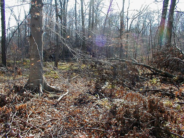
Stepping over a few fallen branches, we hiked our way into the woods. Thirty
meters in, we came across a large pile of tree debris. Obviously, a tree
had fallen in the recent past and had been discarded here. I wonder, did
the people depositing the debris know they were covering a confluence?
Both GPSs were converging on every Confluence Hunter's dream of all zeros.
At first the confluence seemed to be smack-dab in the debris pile, I (Rich)
climbed in to take a look around
. No luck. Meanwhile, Dave circled just to the north and west ends of the
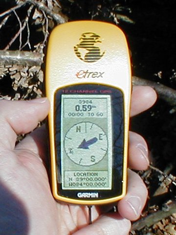
debris pile. Dave's eTrex finally settled on all zeros on a spot near the
northwest corner of the debris pile. Dave snapped a photo
of his eTrex
. I climbed out of the pile and a few minutes later, my Palm V/Earthmate
combo (running Delorme Solas Pro) also reached all zeros about a meter and
a half from where Dave had found it. I quickly took a
screenshot of my Palm
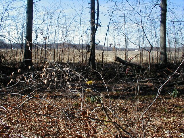
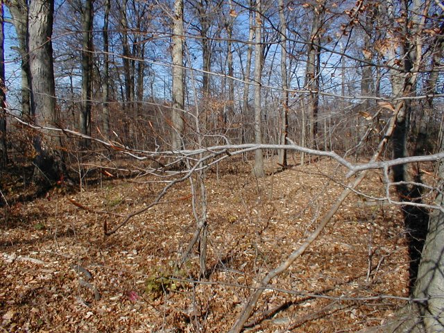
. Ah! Sweet success! Dave then took the obligatory photos to of the views
from the confluence to the West
(farmhouse(s) in the distance), North
, East
(note the debris pile) and South
. Our host, Mr. Blevins, agreed to take a picture of us
standing on the confluence site
(Dave is on the left).
Emerging from the woods, we saw it would be much easier to return by following
the north end of the cornfield. Cloven tracks in the dry mud lead in and
out of the cornfield chronicling a few deer scavenging for leftovers. As
we walked back, Mr. Blevins told us that his family owned the land, but had
leased the field to a neighbor farmer to grow feed corn. We exited the cornfield
via the same gate we had entered.
Compared to
our last foray into Confluence Hunting
, this confluence was a piece of cake! I'll take near 0% grade over what
seemed like 100% grade any day. Having left my (Rich's) duplex at noon, we
returned only 4 hours later. A far cry from the 14+ hours spent in southeast
Kentucky. Finally, a confluence where our GPSs read ?dead nutz on.?


")


")

![Visit #3: [04-Jun-16]](/us/oh/n39w084v3/preview.jpg "Visit #3: [04-Jun-16]")
![Visit #1: [04-Mar-00]](/us/oh/n39w084/preview.jpg "Visit #1: [04-Mar-00]")
")