|

Kenya : Rift Valley
7.6 km (4.7 miles) WSW of Nanyuki, Laikipia, Rift Valley, Kenya
Approx. altitude: 1856 m
(6089 ft)
([?] maps: Google MapQuest OpenStreetMap ConfluenceNavigator)
Antipode: 0° 143°W
Accuracy: 7.7 km (4.8 mi)
Quality: good
Click on any of the images for the full-sized picture.


| 0° 37°E (visit #1) | (incomplete) |
![Visit #5: [22-Apr-07]](/ke/all/n00e037v5/preview.jpg "Visit #5: [22-Apr-07]")
![Visit #2: [13-Jun-02]](/ke/all/n00e037v2/preview.jpg "Visit #2: [13-Jun-02]")
![Visit #4: [05-Mar-06]](/ke/all/n00e037v4/preview.jpg "Visit #4: [05-Mar-06]")
![Visit #3: [18-Jul-04]](/ke/all/n00e037v3/preview.jpg "Visit #3: [18-Jul-04]")

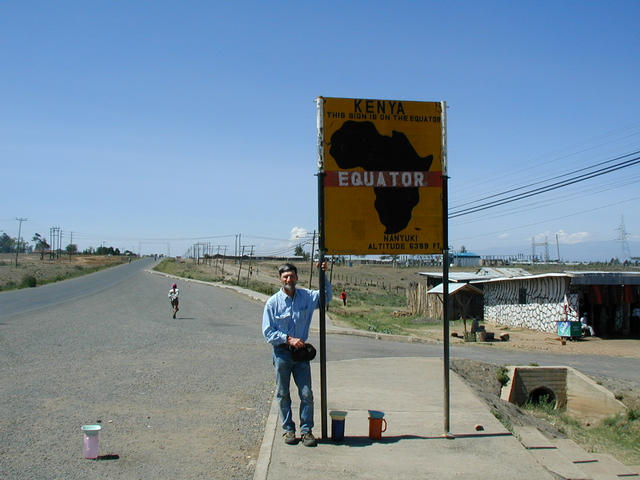
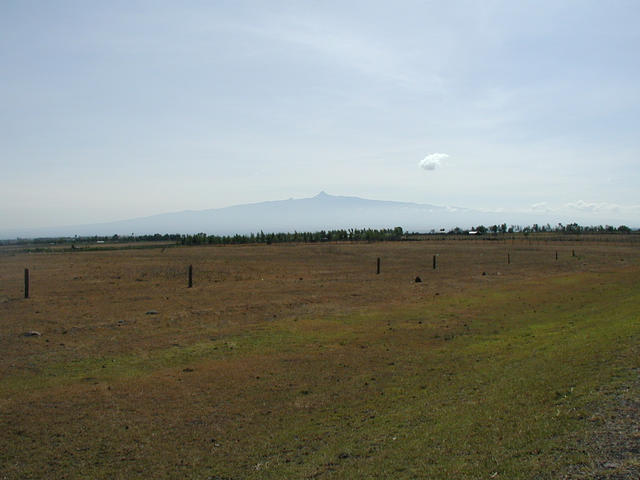
(visited by Dale Stahlecker) 20-Feb-2001 -- I was in Kenya with my GPS receiver in February 2001. I did not learn about the Confluence Project until August 2001. You do the Math! Yet when I check the website I find no Confluence photos for Kenya nor are there any yet reported for the length of the Equator through Africa. Though I did not really attempt to reach any Confluences, I did come within 5 miles (8 km) of 4 of them, and photo documented several sites very close to these Confluences. This one is perhaps most interesting. We crossed the Equator on Highway A2 on 18 and again 20 February 2001, when we stopped for the photograph of the sign marking it. At that point I was 4.77 miles (7.68km) due east of 0° and 37°E. The huge mass of Mt. Kenya, topped by its twin peaks of Bation at 5,199 m (17,057 ft) and Nelion at 5,188 m (17,021 ft) would certainly be the dominant feature in any photograph taken toward the east from the Confluence. The twin summits of Mt. Kenya are less than 10' south of the Equator. I attached two photos of Mt. Kenya, one taken closer and from north of the Equator, and another taken from farther to the southwest of the Confluence. My other brushes with Kenyan Confluences were as follows: 1) 1°S 37°E. I spent the nights of 16 and 17 February in Thika. My hotel was at the confluence of two streams that was 4.86 miles (7.82 km) from this Confluence, and we drove within 2 miles (3 km) of it on 17 February. 2) 0° 36°E - We passed within 3 miles (5 km) of this Confluence while traveling between Lake Nakuru and Lake Baringo on 22 February. 3) 1°N 37°E - The main road through Kitale (24 and 25 February) took us within 0.4 miles (0.6 km) of this Confluence! Public streets might have made this Confluence the easiest to reach. I went to Kenya to see wildlife and saw much more. As with many third world countries, Kenya has magnificent natural wonders under duress from a burgeoning human population. Most people still cook with wood, so forests and their dependent wildlife are disappearing at an alarming rate. Tourists (with their foreign currencies) at major national parks to see African large mammals is an important element in keeping those ecosystems operating. The smaller more secretive wildlife of the forests are less attractive to Ecotours, but no less valuable. Go, visit, spend, and nail a few Confluences! |
| All pictures |
| #1: 17,000 ft Mt. Kenya dominates region #2: Confluence off to right in this photo #3: What Mt. Kenya should look like from Confluence #4: Waterfall < 5 miles from 1S 37E ALL: All pictures on one page |
| Notes |
|
This is the second highest Confluence on the Equator. |