|

Germany : Hessen
1.5 km (1.0 miles) SSE of Mainhausen-Zellhausen, Hessen, Germany
Approx. altitude: 134 m
(439 ft)
([?] maps: Google MapQuest OpenStreetMap ConfluenceNavigator)
Antipode: 50°S 171°W
Accuracy: 10 m (32 ft)
Quality: good
Click on any of the images for the full-sized picture.


")
| 50°N 9°E (visit #2) |
![Visit #26: [04-Jun-25]](/de/all/n50e009v26/preview.jpg "Visit #26: [04-Jun-25]")
![Visit #25: [13-Dec-23]](/de/all/n50e009v25/preview.jpg "Visit #25: [13-Dec-23]")
![Visit #24: [16-Jun-23]](/de/all/n50e009v24/preview.jpg "Visit #24: [16-Jun-23]")
![Visit #22: [21-Jul-22]](/de/all/n50e009v22/preview.jpg "Visit #22: [21-Jul-22]")
![Visit #21: [10-May-18]](/de/all/n50e009v21/preview.jpg "Visit #21: [10-May-18]")
![Visit #20: [16-Aug-15]](/de/all/n50e009v20/preview.jpg "Visit #20: [16-Aug-15]")
![Visit #19: [20-Nov-14]](/de/all/n50e009v19/preview.jpg "Visit #19: [20-Nov-14]")
![Visit #18: [05-Apr-14]](/de/all/n50e009v18/preview.jpg "Visit #18: [05-Apr-14]")
![Visit #17: [01-Mar-14]](/de/all/n50e009v17/preview.jpg "Visit #17: [01-Mar-14]")
![Visit #16: [10-Jul-13]](/de/all/n50e009v16/preview.jpg "Visit #16: [10-Jul-13]")
![Visit #15: [02-Mar-09]](/de/all/n50e009v15/preview.jpg "Visit #15: [02-Mar-09]")
![Visit #14: [25-Feb-09]](/de/all/n50e009v14/preview.jpg "Visit #14: [25-Feb-09]")
![Visit #13: [26-Dec-08]](/de/all/n50e009v13/preview.jpg "Visit #13: [26-Dec-08]")
![Visit #12: [01-Aug-08]](/de/all/n50e009v12/preview.jpg "Visit #12: [01-Aug-08]")
![Visit #11: [29-Nov-07]](/de/all/n50e009v11/preview.jpg "Visit #11: [29-Nov-07]")
![Visit #10: [05-May-05]](/de/all/n50e009v10/preview.jpg "Visit #10: [05-May-05]")
![Visit #9: [23-Jan-05]](/de/all/n50e009v9/preview.jpg "Visit #9: [23-Jan-05]")
![Visit #6: [22-Feb-03]](/de/all/n50e009v6/preview.jpg "Visit #6: [22-Feb-03]")
![Visit #5: [21-Apr-02]](/de/all/n50e009v5/preview.jpg "Visit #5: [21-Apr-02]")
![Visit #4: [23-Dec-01]](/de/all/n50e009v4/preview.jpg "Visit #4: [23-Dec-01]")
![Visit #3: [06-Oct-01]](/de/all/n50e009v3/preview.jpg "Visit #3: [06-Oct-01]")
![Visit #1: [10-Dec-00]](/de/all/n50e009/preview.jpg "Visit #1: [10-Dec-00]")
![Visit #23: [10-May-14]](/de/all/n50e009v23/preview.jpg "Visit #23: [10-May-14]")
![Visit #7: [25-Jul-04]](/de/all/n50e009v7/preview.jpg "Visit #7: [25-Jul-04]")
![Visit #8: [31-Jul-04]](/de/all/n50e009v8/preview.jpg "Visit #8: [31-Jul-04]")
 the tripod marker in dense beechwood")
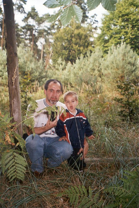
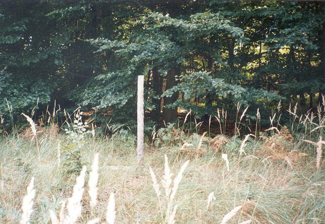
(visited by Gerhard Kaufmann, Jamila Ahejjam and Marwan Kaufmann) 02-Sep-2001 -- Some weeks ago, I read about the Confluence Project and I'm glad to say that I don't belong to the type of people whose only reaction is a pitying shaking of their heads in an absolute lack of understanding and appreciation. On the contrary, I was fascinated and eager to take part in the project. Therefore, I purchased a GPS receiver, learned to use its features and looked for a suitable CP to do a first try. All CPs in my vicinity have already been discovered, nevertheless I chose 50N 9E which is the nearest CP (approx. 50 km) to my hometown Mörlenbach, and which seemed easily reachable and thus being a good exercise for the more difficult ones to come. On this warm and sunny Sunday, my wife, my son and I set out to drive close to the chosen CP. We approached it from a roughly SSW direction via country roads in the hilly region of the Odenwald. We passed the small towns Groß-Umstadt with the impressive medieval castle "Veste Otzberg" nearby, and Babenhausen, and crossing the Autobahn (expressway) A3 in its section Frankfurt - Würzburg (picture #4), we arrived at the small town Zellhausen, which is closest to the CP. To reach the CP from Zellhausen you only have to follow a small road leading 500 m south to the forest, leave your car on a parking space for forest-strollers and start a short hike for approx. 400 m on a good forest lane until you get close to less than 100 m from the CP. The forest consists typically of beech and pine trees, after penetrating a line of young pines (in the background of picture #2) we entered a small, secluded clearing covered with high grass, and at its southern end I could soon make out the tripod already described by Gilles and Erika (picture #1). It was still there since their visit 9 months ago, only the painted numbers 50 and 9 meanwhile seemed quite weathered and were barely readable. When zeroing in with the GPS receiver on the exact coordinates 50N and 9E, I found that indeed the tripod was not exactly positioned, as the "right spot" is to be found some meters southwest of the tripod, but in dense beechwood. Because of the dense treetops there, the GPS receiver could only catch a few satellites with weak signals (estim. accuracy 10-15 m), and although I tried for quite a long time, it was impossible to get a stable all-zeroes-display (picture #3). The darkness beneath the trees made it also difficult to shoot some meaningful pictures of the spot. The CP is indeed VERY close to the Autobahn (no more than 10-20 m), all the time the sound of cars rushing-by was to be heard, although they could hardly be seen because of the dense forest. Overall, an easy to reach but no spectacular CP. Nevertheless, maybe worth a little bit more indication for unaware passers-by. We celebrated this our first successful CP with delicious Paella in a Spanish restaurant in the city of Darmstadt on our way back home, and decided to try an undiscovered CP soon. To be continued... |
| All pictures |
| #1: The CP 50N 9E lies some meters behind (southwest of) the tripod marker in dense beechwood #2: My son and me at the tripod marker #3: GPS receiver display #4: View of the Autobahn A3 looking east towards the CP (1 km away) ALL: All pictures on one page |