|

France : Occitanie
2.3 km (1.4 miles) SW of Massillargues-Attuech, Gard, Occitanie, France
Approx. altitude: 169 m
(554 ft)
([?] maps: Google MapQuest OpenStreetMap ConfluenceNavigator)
Antipode: 44°S 176°W
Accuracy: 7 m (22 ft)
Quality: good
Click on any of the images for the full-sized picture.


| 44°N 4°E (visit #1) |
![Visit #11: [22-Feb-24]](/fr/all/n44e004v11/preview.jpg "Visit #11: [22-Feb-24]")
![Visit #10: [23-Sep-23]](/fr/all/n44e004v10/preview.jpg "Visit #10: [23-Sep-23]")
![Visit #9: [14-Mar-14]](/fr/all/n44e004v9/preview.jpg "Visit #9: [14-Mar-14]")
![Visit #8: [05-Dec-10]](/fr/all/n44e004v8/preview.jpg "Visit #8: [05-Dec-10]")
![Visit #7: [07-Jul-05]](/fr/all/n44e004v7/preview.jpg "Visit #7: [07-Jul-05]")
![Visit #6: [30-Jun-05]](/fr/all/n44e004v6/preview.jpg "Visit #6: [30-Jun-05]")
![Visit #5: [31-May-05]](/fr/all/n44e004v5/preview.jpg "Visit #5: [31-May-05]")
![Visit #3: [24-Jul-04]](/fr/all/n44e004v3/preview.jpg "Visit #3: [24-Jul-04]")
![Visit #2: [13-Jul-04]](/fr/all/n44e004v2/preview.jpg "Visit #2: [13-Jul-04]")

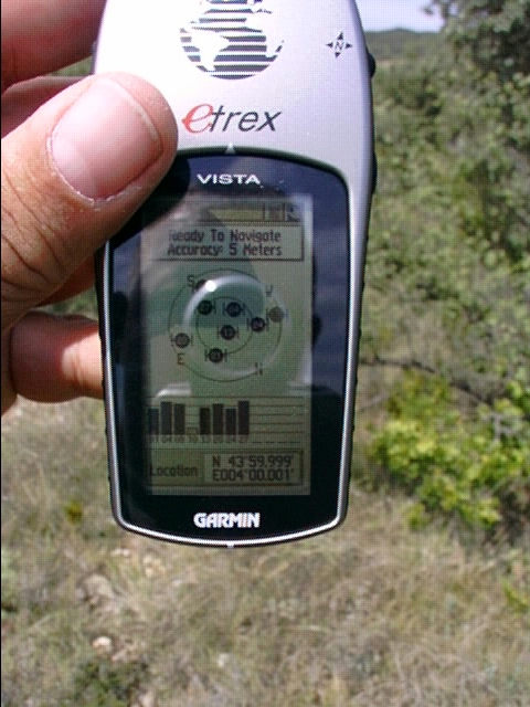
(visited by Roeland Pouwels) 08-Aug-2001 -- Passing our holidays in the Ardeche, we just had to do this DCP, since this was only 40 km's away from our camping site. Zooming in without a proper topographic map, we came across a very desolate camping site with only a few inhabitants, looking very strangely at us. Parking the car in their backyard, onloading my daughter Lenke of 1,5 years old, we (my wife Wendy and I) took off for the last few 300 meters. Using my new Etrex Vista we followed a small gravel-road, as the track directed us in the middle of thorny bushes. At the spot, I managed to mark a waypoint exactly at the .0000 of this DCP. Picture 2 shows the next moment. The pictures will give a slight impression of the remote area. What you can't see, is the temperature of 35°C. The city of Anduze is nearby, The giant Bamboo forestpark is well worth visiting. |
| All pictures |
| #1: DCP 44N 4E #2: Mark and set #3: Looking to the south #4: Looking to the north ALL: All pictures on one page |