|

Greece
2.3 km (1.4 miles) NE of Kalamítsi, Kentrikí Makedonía, Greece
Approx. altitude: 7 m
(22 ft)
([?] maps: Google MapQuest OpenStreetMap ConfluenceNavigator)
Antipode: 40°S 156°W
Accuracy: 5 m (16 ft)
Quality: good
Click on any of the images for the full-sized picture.


| 40°N 24°E (visit #1) |
![Visit #5: [27-Sep-12]](/gr/all/n40e024v5/preview.jpg "Visit #5: [27-Sep-12]")
![Visit #4: [21-Aug-06]](/gr/all/n40e024v4/preview.jpg "Visit #4: [21-Aug-06]")
![Visit #2: [02-Sep-04]](/gr/all/n40e024v2/preview.jpg "Visit #2: [02-Sep-04]")
![Visit #3: [18-Aug-04]](/gr/all/n40e024v3/preview.jpg "Visit #3: [18-Aug-04]")

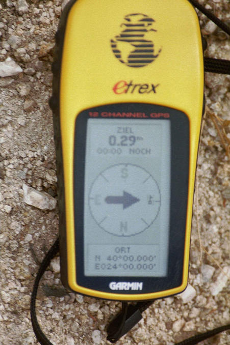
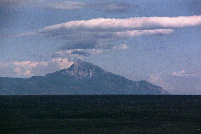
(visited by Stefan Beiergroesslein and Werner Beiergroesslein) 07-Sep-2001 -- We (my father Werner and me) started this trip from our holiday residence in the village of Pirgadhíkia about 45 km north of the Confluence. This Confluence gave us a little thrill in advance, because all available maps showed the spot to be exactly on the coastline, so we didn't know if we could reach it on dry land or had to swim the last bit; We prepared ourselves for both eventualities. Up to the last kilometer approaching the Confluence was very easy, because we just had to follow the eastern coast-road of the peninsula Sithonía to almost their southern tip. Shortly before Kalamítsi, about 1 km away from the Confluence, we took a turn-off into a country road; the sign at the road says "Camping Porto" but following the GPS we did not reach the camping site. In a distance of ca. 800 m to the Confluence we didn't dare to continue by car because of the road conditions, so we walked the rest of the way. This turned out to be quite adventurous because the GPS led us over three rocky hills covered with thorny brushwood and being used as a pastureland for goats. We did not meet any of them, but their droppings gave them away and not far from the place where we left the car was an empty goat-enclosure. We reached the Confluence at 12:30 local time. It turned out to be just on dry land in an altitude of 32 m overlooking a nice little bay that opens SE to the Aegean Sea. The pics 1-6 show the view from the confluence in N, NE, E, SE, S and SW-direction and can be laid together to form a ¾-panorama; I didn't complete the circle because in W and NW the confluence-view would just have shown a close-up of some rocks. Pic 7 shows Werner standing on the Confluence. Pic 8 is the GPS-display of the Confluence. In addition to the confluence-pictures I'd like to give you an impression of Mt. Áthos (pic 9), because its majestic view dominates the whole area even though it can not be seen in the confluence bay (he hides behind the hill in NE). Áthos rises its 2033 m right out of sea-level and is the centre of the neighboured peninsula, the Monks' Republic of Athos. A very interesting feature: The monks don't allow any women, children and only a very small number of non-orthodox men to enter their republic. For tourists in the area I recommend a boat-trip along the shoreline of Áthos with a pearlchain of ancient monasteries along the coast to be seen. |
| All pictures |
| #1: North view #2: NE view #3: E view #4: SE view #5: S view #6: SW view #7: Werner standing on the Confluence #8: GPS display #9: Mt. Áthos, not a confluence view ALL: All pictures on one page |