|

Canada : British Columbia
13.1 km (8.1 miles) W of Ladysmith, Vancouver Island, BC, Canada
Approx. altitude: 323 m
(1059 ft)
([?] maps: Google MapQuest OpenStreetMap topo topo250 ConfluenceNavigator)
Antipode: 49°S 56°E
Accuracy: 450 m (492 yd)
Quality: good
Click on any of the images for the full-sized picture.


| 49°N 124°W (visit #1) | (incomplete) |
![Visit #4: [08-Jun-02]](/ca/bc/n49w124v4/preview.jpg "Visit #4: [08-Jun-02]")
![Visit #5: [24-May-11]](/ca/bc/n49w124v5/preview.jpg "Visit #5: [24-May-11]")
![Visit #3: [19-Jan-02]](/ca/bc/n49w124v3/preview.jpg "Visit #3: [19-Jan-02]")
![Visit #2: [20-May-01]](/ca/bc/n49w124v2/preview.jpg "Visit #2: [20-May-01]")

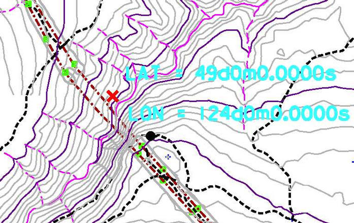
(visited by Dave Patton) 27-Apr-2001 -- I first became aware of the Degree Confluence Project earlier this year, and it coincided nicely with the timing of the purchase of my first GPS receiver. Looking through the site, I discovered that British Columbia, Canada did not have a confluence index, so I contacted Alex and volunteered to provide one. While working on the index, I observed some confluences that seemed like they might be reached without too much difficulty, such as 49N 124W, while others might require a fully equipped mountaineering expedition, such as some of the confluences in the Coast Mountains, on the border with the Alaskan panhandle. On the morning of April 27th, I set out for a trip from home in Vancouver to visit family in Victoria. Normally I take the BC Ferry (www.bcferries.com) from Tsawwassen to Swartz Bay, but I decided to take the ferry from Horseshoe Bay to Departure Bay in Nanaimo, and then drive down the Island Highway to Victoria. This would take me through the town of Ladysmith, which is near the confluence. In doing some planning for this first attempt at a confluence, I had determined that the area of the confluence could be reached by logging roads, but that the confluence itself was located in a ravine above Haslam Creek, almost below where two high-voltage transmission lines cross the ravine. Speaking to the forestry company that owns the land in the area, I found out that the road on the map that appeared to take me almost to the confluence is blocked in two places by locked gates. I was informed that I would have to use a different road, one which also gets close to the confluence, but on the opposite side of the ravine. Having a detailed map showing the confluence on a steep bank above a creek, and finding out that the closest vehicle approach was likely on the opposite side of the creek, and knowing I had a dinner appointment in Victoria left me wondering if I would have success with my first confluence hunting trip. I departed my home in Vancouver at 7:15AM, and drove to the Horseshoe Bay ferry terminal, and caught the 8:30AM sailing. The ferry ride to Nanaimo takes one and a half hours, and I was at the Nanaimo office of the BC Government’s Ministry of Forests (www.gov.bc.ca/for/) by 11:15AM, where I picked up a hardcopy brochure of a map available on the internet. I then drove back to the highway, and headed southbound to Ladysmith. I knew from talking to the timber company that the logging road I wanted (Ladysmith Main) started at the end of Christie Road in Ladysmith, but I didn’t have a street map for Ladysmith, so I turned off the highway at Roberts Street (next to the City Hall), turned right onto First Avenue, parked, and went into the business in front of my vehicle to ask directions. I had seen something on the window about winemaking supplies, so I thought I was going into a "U-brew" winemaking shop, which are quite popular (we have very high liquor taxes), but I soon realized that this shop provided a ‘variety of services’. The person who went in just before me was having the owner send a fax for him, and while waiting and looking around, I saw a dry-cleaning rack, a photocopier, and a table with various tools for sale. The owner was quite helpful, providing me with a small map showing the streets, and, along with the person sending the fax, directions to Christie Road. Just past the Hospital, I turned right past the Cemetery (hopefully the proximity is just coincidence!), and onto Christie Road, which ends at a large unlocked gate, where the gravel logging road starts (0 KM). At 10 KM I went to the right, at the Ladysmith Main sign. At 11.6 KM, I again went right, on Haslam Main. At 13.5 KM, I stayed to the left (Timberlands Main is to the right). At 14.7 kilometers I was on the Haslam Main logging road, directly under the twin transmission lines. I knew I was close, but I hoped that there would be a road that would take me to the other side of the ravine, and it did appear on the map that this might be the case. I continued further up the road, stopping to take a picture of a small creek at 18.4 KM (Picture #2). At 20.8 KM I turned right over a bridge with a gate. I suspected this was Haslam Creek, which would be good, as I was trying to get onto a logging road on the other side of the Haslam Creek ravine. The ‘good idea’ came to an abrupt end when rounding a corner 5.4 KM from the bridge I came to the ‘end of the road’ – a creek! In fact, the road continued on the other side of the creek, so maybe at some point there had been a bridge which has been removed, or maybe when building the road they ran the creek through a culvert. In any case, even though I have a four wheel drive vehicle and could have made it across to the other side, I was alone, had limited time, didn’t know if the road on the other side went where I wanted to go, and didn’t know if someone might lock the gate back at the bridge, so I decided to return. On the way back, I met a forestry crew, just past the bridge and gate, and they confirmed that the bridge was crossing Haslam Creek. I drove back to the spot just under the transmission lines, and then drove a few hundred metres down a service road directly under the transmission lines, towards Haslam Creek. The road terminates at the base of a transmission tower, at the top of the ravine. By this time, I realized this was going to have to be listed as an attempt, because I did not have the time left to work my way down this side of the ravine, find a way across the creek, locate and document the confluence on the opposite side of the ravine, get back, and then drive to Victoria in time for dinner. Picture #1 is looking across the ravine, with Haslam Creek at the bottom. The confluence is located somewhere just below the center of the picture, and Picture #3 shows my position while taking these pictures. Picture #6 is a map image, with 20 meter contour intervals. The red X marks the confluence. This is an ‘exact’ location, having been produced from GIS mapping software (as was the map image). I added the black dot to indicate the position where I took the pictures. I said at the start that I was "wondering if I would have success with my first confluence hunting trip", and now I knew that success would have to come another day. It is a good thing I’m not superstitious – I realized when marking a waypoint for the spot shown in Picture #3 that it was waypoint number 13, and when I went to take the picture of the GPS, I realized that it was frame 13 on the roll! |
| All pictures |
| #1: View across the ravine to the confluence #2: Small creek on Haslam Main logging road #3: Closest approach for this attempt #4: View down the ravine #5: View up the ravine #6: Map image showing confluence and picture locations ALL: All pictures on one page |