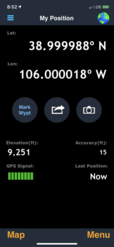
|
United States : Colorado
13.0 miles (20.9 km) NE of Buena Vista (Chaffee), Park, CO, USA
Approx. altitude: 2827 m
(9274 ft)
([?] maps: Google MapQuest OpenStreetMap topo aerial ConfluenceNavigator)
Antipode: 39°S 74°E
Accuracy: 10 m (32 ft)
Quality: good
Click on any of the images for the full-sized picture.
| 39°N 106°W (visit #8) |
 (visited by Aaron B) 01-Jul-2020 -- What a beautiful morning for a confluence visit! I left my accommodation in Fairplay around 8 am heading south on US 285. After turning west onto road 402, the road immediately becomes dirt. I passed private lands on both sides for about 1 mile until coming to the gate mentioned by Dr. Kerski in his 2015 visit. Unlike his visit, this gate was open for me. The sign on it mentioned that it is closed from January 1 to June 15 to protect local wildlife, but one could easily park outside this gate and walk if it is closed. After passing this gate, there were signs indicating I was now on forest land. I took the first right after the Forest Service signs, which Google calls FS Trail 168. This turnoff is about 2000ft after the gate. Once on FS 168, the next landmark is a cattle guard. There I decided to park and walk because I was not sure if my sedan could safely cross the stream crossing that was just after the cattle guard. I walked across the cattle guard and two stream crossings then came to a fork where the newer dirt road goes right and the older decommissioned dirt road to the left continues towards the confluence. Take the left fork (on foot; no motor vehicles allowed). Right before the third stream crossing, I saw that the confluence point was just off trail to the right, on the gently sloping open field. There was a deer who spotted me approaching and quickly ran off. No other land animals or humans were seen on this trip. At the confluence point, there is a metal box which I discovered was a geocache upon opening it. There were knick knacks and a log book inside. After signing it with a quick message, I snapped some pictures. There are wonderful views all around, but the Buffalo Peaks (13300 ft elevation) to the west stand out prominently and are the highlight of this point. After about 10 minutes I got my fill of pictures and scenery and headed back to the car. I was back in Fairplay before 10 am. The weather this day was perfectly sunny and 54°F, the trail was dry except near the stream crossings which are easy on foot, and the terrain is relatively flat. The total distance walked was about 2.2 miles roundtrip. I highly recommend this one to anyone wanting a quick and scenic confluence point visit! |
| All pictures |
| #1: View of the confluence point and geocache, looking north #2: Looking west from the confluence point towards the Buffalo Peaks #3: Looking south from the confluence point #4: Looking east from the confluence point #5: Geocache box right on the spot #6: Evidence #7: First gate which may be seasonally closed #8: Cattle guard #9: After two stream crossings, take this left fork ALL: All pictures on one page |


![Visit #9: [19-Jul-21] Visit #9: [19-Jul-21]](/us/co/n39w106v9/preview.jpg)
![Visit #7: [05-Sep-15] Visit #7: [05-Sep-15]](/us/co/n39w106v7/preview.jpg)
![Visit #6: [11-Apr-14] Visit #6: [11-Apr-14]](/us/co/n39w106v6/preview.jpg)
![Visit #5: [04-Apr-13] Visit #5: [04-Apr-13]](/us/co/n39w106v5/preview.jpg)
![Visit #4: [12-Jun-10] Visit #4: [12-Jun-10]](/us/co/n39w106v4/preview.jpg)
![Visit #3: [13-Sep-03] Visit #3: [13-Sep-03]](/us/co/n39w106v3/preview.jpg)
![Visit #2: [29-Sep-01] Visit #2: [29-Sep-01]](/us/co/n39w106v2/preview.jpg)
![Visit #1: [24-Jul-00] Visit #1: [24-Jul-00]](/us/co/n39w106/preview.jpg)