|

United Kingdom : England
2.1 km (1.3 miles) W of Longtown, Cumbria, England, United Kingdom
Approx. altitude: 9 m
(29 ft)
([?] maps: Google MapQuest OpenStreetMap ConfluenceNavigator)
Antipode: 55°S 177°E
Accuracy: 216 m (708 ft)
Quality: good
Click on any of the images for the full-sized picture.


| 55°N 3°W (visit #2) | (incomplete) |
![Visit #3: [18-Jun-02]](/uk/en/n55w003v3/preview.jpg "Visit #3: [18-Jun-02]")
![Visit #6: [25-Dec-19]](/uk/en/n55w003v6/preview.jpg "Visit #6: [25-Dec-19]")
![Visit #5: [22-May-08]](/uk/en/n55w003v5/preview.jpg "Visit #5: [22-May-08]")
![Visit #4: [11-Sep-05]](/uk/en/n55w003v4/preview.jpg "Visit #4: [11-Sep-05]")
![Visit #1: [30-Aug-01]](/uk/en/n55w003/preview.jpg "Visit #1: [30-Aug-01]")

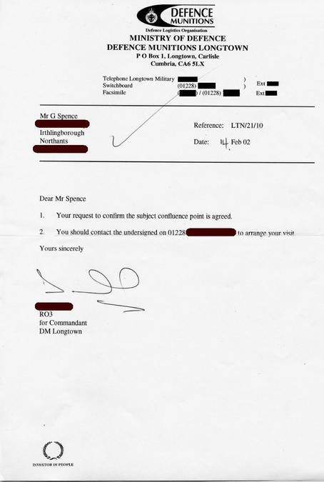
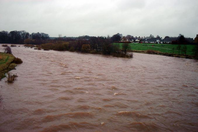
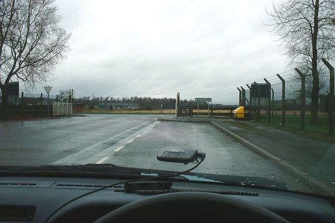
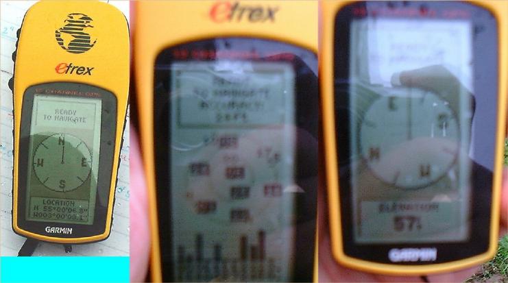
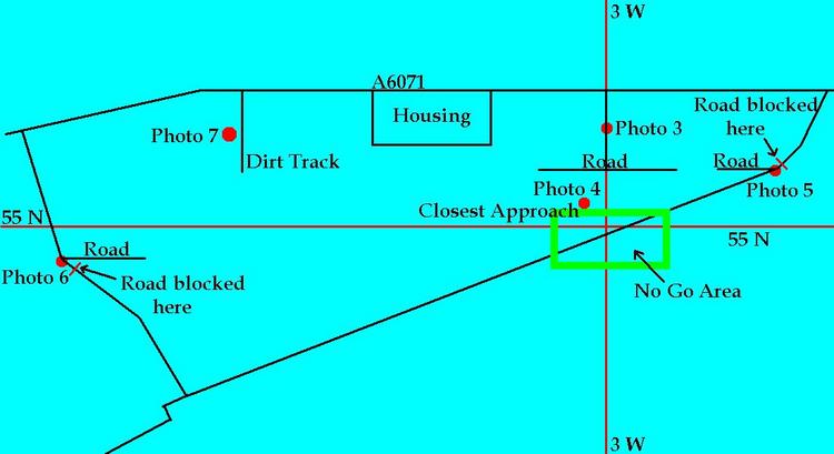
(visited by Gordon Spence) 26-Feb-2002 -- Jan-2002: Right then, the last unvisited point in England. I was intrigued by the previous unsuccesful visit. Close examination of the maps suggested an unmarked unclassified road (from the road system point of view, not the military) that went around the back of the CP. In fact it appeared to pass within about 30m of the point, certainly close enough. On my trip up to 55N 5W (12-Jan-2002) I detoured slightly East to check this out. Taking the road indicated I followed it for about 500m until I came to a locked and barred gate with a big "We are Military, go away or else" sign. Not quite the exact wording, but you get the meaning. I reckoned this was about 600m away. Hmmm...back to the main road and drive slowly (not too slowly though) past the main gate. I notice that the main gate is almost exactly on 3W (give or take about 3-4m anyway). I carried on past and found a track to the left. There was a sign at the entrance saying basically, this was National Woodland, please feel free to walk. Then 200m further on is a sign off to the right, say Military go away! If you head off to the left, there are no signs...but you are heading towards the base. This appears to be down towards the previous visitor's picture 4. Going further West revealed a small paved road to the South. Following this as far as you can go, you again come to a large gate telling you to go away. I then went back to the guard post and explained what I was doing. Having visited other government security controlled sites I knew that there was no way in without my name being on a list. I asked for and was given the postal address of the base and the rank of the Officer Commanding. When I returned home I wrote and asked for permission to visit. Since then I have been to the USA again, where I took in two points in California, seven in Texas (including two first time visits). Three weeks after writing I received a letter confirming that I could visit the base. I phoned up and confirmed the date of my visit as 26th February. The 26th February: First off, I had better explain that there won't be the normal locating photographs of this CP, it is located in the heart of a restricted military area. I got up at 4.00am and was on the road for 4.45am. The weather was heavy rain and strong winds, the forecast was more of the same. Oh well, off up the road and the car is being blown about - that wind sure was strong. A couple of hours later and I had to take a detour off the motorway (freeway) because the main bridge North is closed due to high winds! I pull over and consult my map, a new area to me and the morning commuter rush hour is getting well under way. About an hour later and I am back on the motorway, making good time. I pulled into a service area, filled up with petrol, coffee and some food, then a quick half-hour cat-nap to freshen up. Carrying on North, and I leave the motorway some 40 exits and about 200 miles after having joined it. Looping around to the right and then swinging back left brings me to the River Esk. As you can see the river is well up (I was told later, about 30 feet up), this picture is looking West directly towards the confluence point a couple of miles away. I presented myself at the gatehouse at the agreed time, with photo-id to prove who I was. I had to sign a Health and Safety disclaimer which gave instructions what to do in an explosives emergency (basically, run for it!). This base is one of the two largest munitions stores in the UK. After collecting my pass and vehicle pass I parked in front of the main building and was met by my escort - a retired Major (sorry, no names). We walked down the main entrance road which lay on exactly 3W, towards some buildings. At a cross-roads we could go no further South. We turned West until we came to a gap in the buildings. I asked if we could go a bit further South, we could, about another 50m. At this point we had to come to a halt. I saw a van passing along the diagonal road on my diagram. I asked if we could get onto that road. It was not permitted. That was a "restricted area". I didn't ask why, but given the purpose of the base you can draw your own conclusions. I took my GPS photos, I don't know why but only two out of nine shots weren't blurred! At this point I was about 216m away from the CP. I have drawn a diagram. It has parts missing, as to obtain these details you have to be on restricted military property. It does show information that can be obtained from published maps, or can be seen from public land. Oh yes, I almost forgot, this was the base that all the wreckage from the Lockerbie Panam 259 bomb was taken to. |
| All pictures |
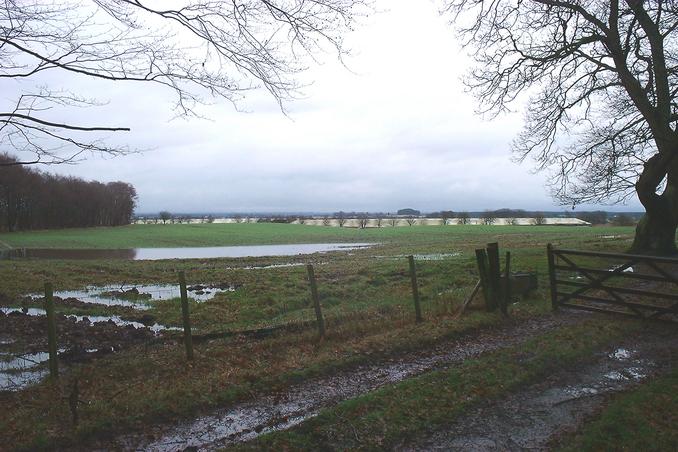
| #1: Looking N from the guardhouse #2: Letter giving permission #3: West towards the CP, river is 30feet up on normal #4: GPS collage #5: Closest from the East #6: Closest from the West #7: Welcome, or not! #8: Straight towards the base and the CP #9: Diagram of the area ALL: All pictures on one page |