|

United States : Washington
10.2 miles (16.4 km) E of Laurier (Ferry), Stevens, WA, USA
Approx. altitude: 1215 m
(3986 ft)
([?] maps: Google MapQuest OpenStreetMap topo aerial ConfluenceNavigator)
Antipode: 49°S 62°E
Accuracy: 1 m (3 ft)
Quality: good
Click on any of the images for the full-sized picture.


| 49°N 118°W (visit #2) |
![Visit #1: [03-May-02]](/us/wa/n49w118/preview.jpg "Visit #1: [03-May-02]")

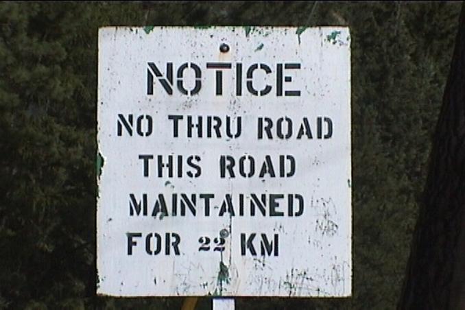
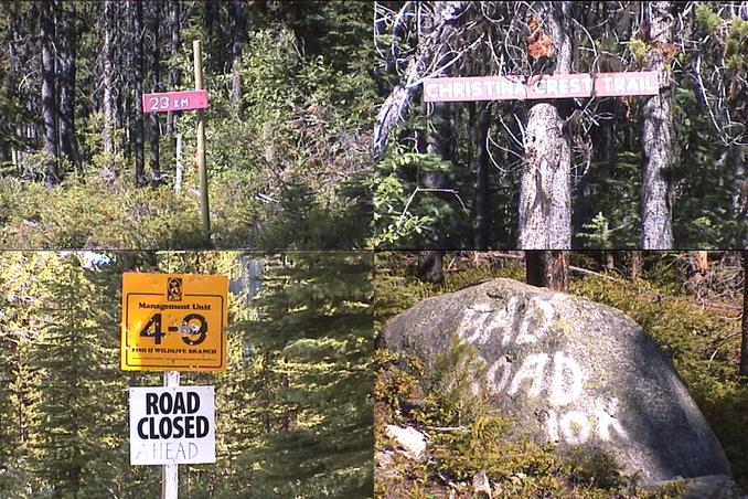
(visited by Dave Patton) 01-Aug-2002 -- After my visit to 49°N 119°W I drove back to Highway 3 at Rock Creek, and continued east, through Midway, Greenwood, and Grand Forks, arriving at Christina Lake just before 4PM. The previous visitor had approached the confluence from the Rossland side, but Volume IV of the Backroads Mapbook showed the "Old Cascade Highway" connected through to Christina Lake, so I wanted to take that route rather than taking Highways 3 and 3B to Rossland. After looking for a roadsign for the "Old Cascade Highway" with no luck, I asked at a gas station in Christina Lake, but they didn't know, and suggested I go and ask at WildWays. A helpfull staffperson in the store explained that the road I wanted is the Santa Rosa road, which starts right off the highway. He also explained that the road may not be passable. I went back and found Santa Rosa road, where I also quickly found a sign indicating that I might not make it to where I wanted to go. The road rises up out of the valley containing Christina Lake (the town and the body of water), providing some good views. Along the way I took a picture of the border cutline. The road continues to climb, reaching an area near the ridge in the top of the picture. Once the road reachs the crest of the ridge, at the 23KM marker, there are a number of choices. To the right there were three other gravel roads. I think at least one of these goes to the communications towers on the nearby summit. To the left was the "Christina Crest Trail". Santa Rosa road, which to this point had been a well-maintained gravel road suitable for two-wheel-drive vehicles, continued straight ahead, however, just a little bit further along the road were some signs indicating that the road was closed ahead. 7.8KM along this part of the road I stopped to remove a tree that had fallen across the road. At 9.8KM past the 23KM sign there is an area where the hillside on the downslope side of the road has given way, making for a tricky spot to drive through, and not something I would advise unless you have a 4-wheel drive vehicle. Just beyond this, at 10KM past the 23KM sign, is an even worse area of hillside slippage. Having negotiated the tricky spots on the road, it was only about another kilometer until I reached a better section of road, under some power lines. About 4.5KM further, I reached the bridge over Big Sheep Creek. After turning around and heading back up the road I just came down, I could see a sign beside the road that said "Old Cascade Highway", just before the "Road Not Maintained Beyond This Point" sign that Frank refers to in his narrative. At 3.6KM from the bridge I drove up a road to the left. It's just before the 28 mile marker - if you reach the Santa Rosa Creek BCFS Recreation Site you have gone too far. 1.9KM up this road I turned to the left. To the right was a sign:
       Dewdney Trail
         CROSSING
          Pipeline
     Construction Area
There were also trail signs both uphill and downhill for the Dewdney Trail.
I drove up the road as far as I could, until I reached a
flat area near the upper edge of the clearcut,
where I set up camp.
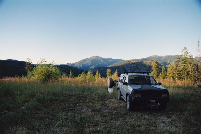
The next morning, before breakfast, I decided to go to the confluence. The hike consisted of going through the rest of the clearcut, then a bit of thick forest. Beyond that was an nice open stretch, but then I hit a steeper area going downhill and through some more heavier forest, before coming out into a more open area as I approached the border cutline. I took a picture of the tree with the bit of flagging tape Frank had left to mark the confluence. The picture to the West is right on the border cutline, with my GPS sitting on top of a hiking pole. Seeing as Frank(who lives in the USA) took a picture "looking south to freedom", I decided to include one "looking north to freedom" in Canada(where I live :) While most of the hike back was essentially the same route, it was different enough in spots to make the hike easier. Once back at my truck I had breakfast, then headed off towards 49°N 117°W. After crossing the Big Sheep Creek bridge, the road winds it's way up the hillside as it heads towards Rossland. I took a picture looking back across the valley. Santa Rosa road reaches it's crest at 23KM on the ridge at the top right of the picture. The wide cutline through the trees in the middle of the picture is for two sets of power lines. Just to the left of that you can see the narrower cutline for a gas pipeline. My campspot was about 2/3 of the way up the clearcut. The border cutline shown in picture 6 comes over the ridge in the background, just barely to the left of the top of the clearcut. The confluence is located beyond and below the ridge in the foreground just to the left of the top of the clearcut. |
| All pictures |
| #1: tree at confluence #2: boundary cutline looking West #3: looking north to freedom #4: GPS reading at the tree #5: sign at start of Santa Rosa road #6: border cutline from Santa Rosa road #7: signs near crest of Santa Rosa road #8: camp spot near upper edge of clearcut #9: view across Big Sheep Creek valley ALL: All pictures on one page |
| Notes |
|
The borderline with Canada is passing 120 ft north of the Confluence. |