|

Romania
6.3 km (3.9 miles) SW of Buciumi, Sălaj, Romania
Approx. altitude: 524 m
(1719 ft)
([?] maps: Google MapQuest OpenStreetMap ConfluenceNavigator)
Antipode: 47°S 157°W
Quality: good
Click on any of the images for the full-sized picture.


| 47°N 23°E |
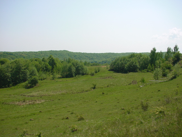
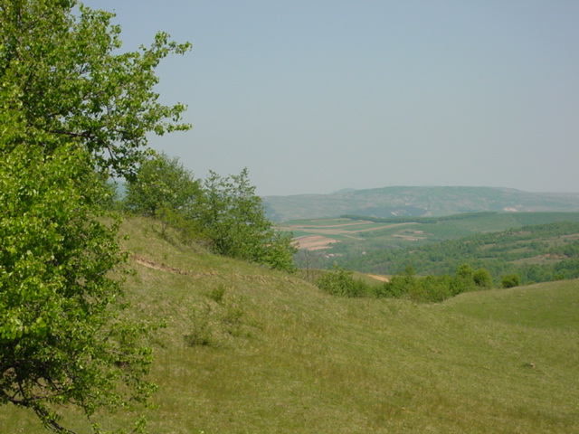
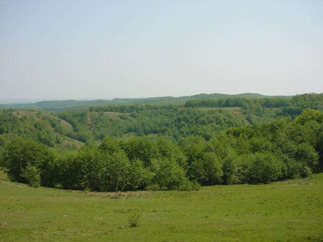
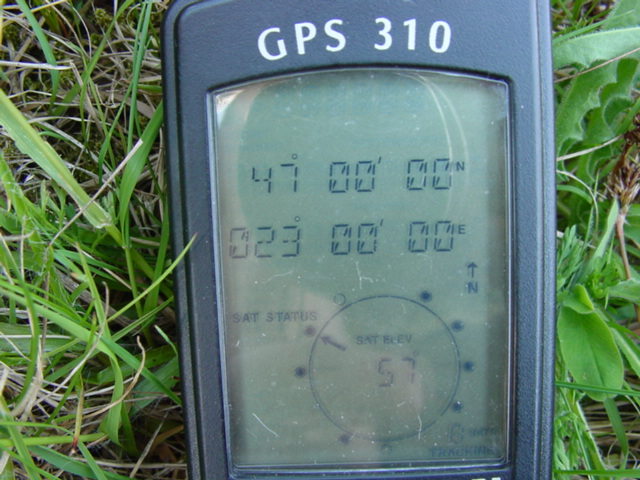
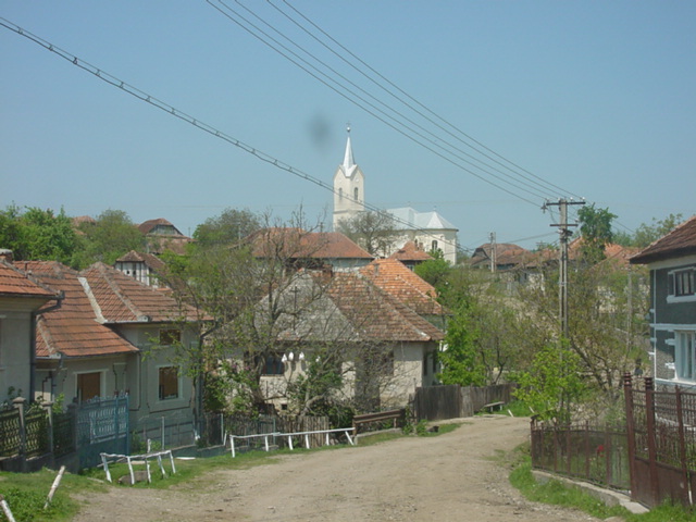
 (visited by Mihai Pitigoi, Andra Costin and Mihnea Costin) 07-May-2002 -- English On our way home from Oradea (see N47E22) we made a detour for N47E23. In Ciucea, after visiting the Goga memorial house (a poet and former prime-minister from the beginning of the 20th century – worthy of a visit, takes less than an hour) we exited Road1/E60 and turned left to Romanasi. The road was crossing the small mountains of Salaj County, a region with lots of mountains and hills, lying in the northern part of the Western Carpathians, where the mountains lose height and become hills. We crossed many villages, but the confluence approached by a very small rate: while we were driving one kilometer the confluence approached by half a kilometer. At some point we thought that we had taken perhaps not the best road to get near the spot. But we decided to keep driving, and after some 20 km from Ciucea, in the village of Bogdana, we turned right, just near the main village church. The confluence seemed to be over a hill. So we drove along a small river that took us just by that hill. After exiting Bogdana the road is so bad that an off-road vehicle is a must. We drove for another 2 or 3 km when the GPS showed the confluence directly up the hill, 500 m further. We left the car under some trees, for shade, and started climbing. The climb was a pleasure: few trees, the terrain being mainly pasture, with lots of field flowers and a warming sun. No animals or humans at all. Just the sound of insects and birds. All around us we could see only forested heights, except for some houses from Bogdana and the farming fields around the village. We reached the spot in about 10 minutes. The elevation was 536 m. We were just 100 m away from the top of the hill, from where I could have taken pictures for a beautiful 360 degree panorama. Pic #1 is a 180 degree panorama, the left side showing the view northwards, towards Bogdana (which cannot be seen because of the hill). On the horizon the Meses Mountains can be seen. The center of the panorama shows the way we climbed to the confluence. Pic #2 is taken southwards. For many miles in that direction there are no human settlements, only forests and hills. Pic #3 is taken northwards. Pic #4 shows the way we climbed to the spot. In front of the near forest you can see a pole: that’s used for hay stacks, but now being spring the hay was recently exhausted. At summer’s end farmers will again gather grass and pile it around that pole. This kind of poles were everywhere on those pastures (in fact poles like that can be seen on every pasture in Romania). Pic #5: the position (all zeros again). Pic #6 is taken on our way back to the main road: you can see the condition of the road that we used to approach the confluence, some houses in Bogdana and some horses, right on the road. Pic #7 shows the main church of Bogdana. This is the point where the road to the confluence reaches the main road Ciucea – Romanasi. If you look through the trees, along the dirt road, you can see that it climbs a slight slope. At the end of the slope it’s the intersection. If you come from Ciucea you turn right when you see that church on your left. In this picture notice also a small bridge, over the main river of the area, Agrij, that flows just between the houses. Getting back to the paved road we decided not to go back to Ciucea but to go on to Romanasi, where we met Road 1F/E81. We had only 70 more km to Cluj (the next important city on our way back to Bucharest) taking this way, while if getting back to Ciucea and on to Cluj the normal way would have been now about 25 km longer. So it was a pretty long detour but worthy, as we mapped the 13th Romanian confluence. 07-May-2002 -- La intoarcerea de la Oradea, unde fusesem de Paste (vezi 47N22E), ne-am abatut pe la 47N23E. In Ciucea, dupa ce am vizitat casa memoriala Goga (merita 45 minute: o casa taraneasca, un conac, o bisericuta de lemn, mausoleul unde e ingropat Goga si o livada intinsa cu privelisti de vis), am parasit DN1/E60 si am facut dreapta spre Romanasi. Mergeam peste dealurile Salajului, ultimile ramasite nordice ale Apusenilor. Am trecut prin destule sate dar confluenta abia se apropia: la un kilometru parcurs pe sosea daca reduceam distanta pina la confluenta cu 500m. La un moment dat ne-am si gindit sa ne intoarcem sa incercam una din bifurcatiile de macadam. Dar, intuitiv, am mers inainte si, la vreo 20 km de Ciucea, in Bogdana, am facut dreapta in dreptul bisericii principale. Confluenta era inainte, de-a lungul unui riu. Am mers pe ulita pina am iesit din sat, iar drumul de pamint se transformase intr-un veritabil drum de tractor sau caruta. Mergeam de-a lungul riului, printre doua siruri de dealuri. Dupa vreo 2 – 3 km GPS-ul ne-a indicat 500 m pina la confluenta, direct spre dreapta. Mai departe distanta crestea iar, asa ca am oprit, am parcat sub niste copaci, la umbra, si am pornit urcusul. Urcusul a fost o incintare: putini copaci (desi toate dealurile din jur erau impadurite), in rest pasuni, flori de cimp, soare prietenos, liniste deplina cu exceptia insectelor si pasarilor, pustiu (nici tipenie de om sau animal). In afara de casele din Bogdana si terenul agricol din jurul satului in jur se vedeau numai dealuri impadurite, iar mai departe, spre nord, citeva culmi muntoase: Muntii Meses. Am ajuns la confluenta in vreo 10 minute. Altitudine 536 m. Eram la nici 100 m de virful dealului, de unde ar fi iesit o panorama de 360 grade. De aici jumatate din perspectiva era blocata de coama dealului. Foto 1 este o panorama de 180 grade. Stinga imaginii este spre nord, spre Bogdana (nu se vede satul fiind chiar sub deal). La orizont se vad Muntii Meses, ultima ramificatie nordica a Apusenilor, muntii de deasupra Zalaului, in fapt o creasta scurta, ingusta si impadurita. In centrul panoramei, spre est, se vede panta pe care am urcat-o. Foto 2 este spre sud. Se vad numai paduri, si kilometri intregi nu este nimic altceva in acea directie, nici macar o casa. Foto 3 este spre nord. Foto 4 arata drumul pe unde am venit. In fata copacilor cei mai apropiati se vede un par de capita. Normal ca, fiind primavara, nu mai are pic de fin. Dar resturi de capite se vedeau peste tot – fireste, fiind inconjurati de pasuni. Foto 5 arata pozitia: iar am nimerit la fix! Foto 6 e facuta pe drumul de intoarcere catre asfalt. Se vede: drumul de caruta spre confluenta, casele din marginea satului Bogdana si citiva cai. Foto 7 e in centrul satului, se vede biserica unde am parasit asfaltul. Ulita se distinge printre copaci cum urca o mica panta. In locul unde se termina panta, chiar linga biserica, se intilneste cu drumul asfaltat Ciucea – Romanasi. Cum vii de la Ciucea trebuie facut dreapta cind biserica e pe stinga. In poza se vede si un pod peste riul Agrij, principalul riu al zonei, care aici curge chiar printre case. Ajungind inapoi la asfalt am observat ca daca ne-am fi intors la Ciucea aveam cam 95 km pina la Cluj, iar daca continuam spre Romanasi si ieseam in DN1F/E81 Zalau – Cluj aveam numai 70 km pina la Cluj. In plus drumul e mult mai bun pe aici, Ciucea – Cluj fiind in reabilitare. Asa ca am pornit pe varianta aceasta. Ocolul ne-a costat destui kilometri si destul timp (2 ore), dar a meritat sa punem pe harta a 13-a confluenta din Romania. |
| All pictures |
| #1: North-East-South panorama/Panorama nord-est-sud #2: Forested hills southwards/Dealuri impadurite spre sud #3: View northwards/Vedere spre nord #4: View eastwards/Vedere spre est #5: GPS #6: Returning to civilization/Intoarcerea la civilizatie #7: Bogdana ALL: All pictures on one page |