|

United States : Wisconsin
3.8 miles (6.2 km) WSW of St. Nazianz, Manitowoc, WI, USA
Approx. altitude: 246 m
(807 ft)
([?] maps: Google MapQuest OpenStreetMap topo aerial ConfluenceNavigator)
Antipode: 44°S 92°E
Quality: good
Click on any of the images for the full-sized picture.


| 44°N 88°W (visit #2) |
![Visit #4: [15-Nov-12]](/us/wi/n44w088v4/preview.jpg "Visit #4: [15-Nov-12]")
![Visit #3: [09-Sep-02]](/us/wi/n44w088v3/preview.jpg "Visit #3: [09-Sep-02]")
![Visit #1: [25-Apr-00]](/us/wi/n44w088/preview.jpg "Visit #1: [25-Apr-00]")

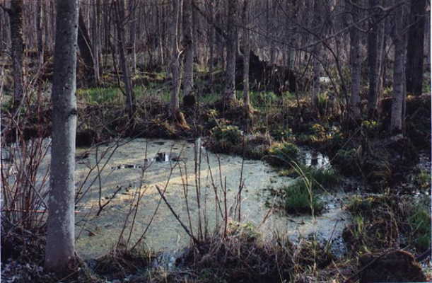
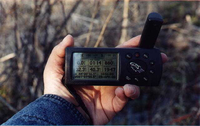
(visited by Dr. Mark W. Palmer and Thomas C.H. Mueller) 20-Mar-2001 -- The confluence of N44 and W088 lies in marsh land north and a little east of Kiel, Wisconsin, which itself is between Lakes Michigan and Winnebago. Perhaps the description by Daniel Klein of a previous attempt on this confluence has discouraged others from trying to visit. I'm happy to report that while this spot was certainly not without its challenges, my co-explorer Thomas C.H. Mueller and I were able to visit it safely and had a very good time seeing the area. This narrative should actually begin with 18-Mar-2001, when I convinced my wife to make a small side trip from visiting family in order to scout the confluence area. For this scouting run, she stayed in the car while I ventured forth and kept in touch via two-way radio. I raced the approaching sunset thinking there might still be a chance to reach the confluence solo before dark. While I did get to the right spot just as the sun was setting, in my haste I had damaged my digital camera and had not thought to bring a spare "disposable" film camera. The badly out-of-focus pictures that the poor, wounded camera yielded didn't seem good enough to cement my claim. Over lunch the following day, Mr. Mueller showed great interest in repeating my trip and getting a proper set of pictures for upload. I briefed him on the lay of the land, and cautioned that I had broken through the softening marsh ice and been in calf-deep water at one point. Considering that the forecast for the week in Wisconsin was day after day of 50-degree-F high temperatures, the smartest way to revisit would be to drive at night and hit the area in the hour before dawn when the ice crust would be most firm. Tom thought this sounded good to him, so I figured out a timetable for us to get there and still get me to work on time in the morning. Traveling during the wee-hours of 20-Mar-2001 was actually rather rewarding. Tom and I saw the Aurora Borealis (a.k.a. northern lights), both of us for the first time in our lives. Normally I would have tried to take a picture, but I knew the disposable film cameras we had wouldn't work for the faint sky glow. Later, at 0401 CST we saw the space shuttle Discovery and the international space station drift in succession through Cassiopeia. Less than an hour after that, an orange crescent moon came up in the southeast as we were driving through Fond du Lac. Tom and I set out on foot from the car about forty minutes before sunrise and about 0.7 miles from the confluence. Our winding route, however, would require about 1.1 miles of hiking and the same coming back. Our two main advantages over Dan Klein's attempt would be (a) visiting before the spring thaw made the entire area a quagmire and (b) approaching from the southwest, which put a much shorter stretch of marsh between us and the confluence (Klein approached from the northeast, as evidenced by his GPS reading). Furthermore, my familiarization trip two days previous sped our progress to the marsh area. We crossed many rolling farm fields separated by low rock walls before reaching the wooded area that surrounded the marsh. I already knew that the confluence was on the east side of Cedar Creek (as the topographic maps and aerial photos asserted), so we availed ourselves of the best fallen-log crossing we could find (approximately 43d 59.917m N, 088d 00.038m W). The east side of the creek here was entirely marsh, and in spots the tall grasses and shrubs were rather thick. I was very happy though that the ice crust was firmer than it was on my previous late-afternoon reconnoiter. Neither Tom nor I got our feet wet on this outing. While the scanned pictures from the disposable cameras are not as crisp and colorful as my digital camera's would have been, at least you can get a good impression of the surroundings. Unfortunately we have no good picture of the GPS reading. The disposables don't focus closer than four feet, and just don't show enough detail on the negatives either. |
| All pictures |
| #1: View looking west from the confluence. Cedar Creek is about 40 feet away. #2: Tom stands upon the confluence point. #3: View looking south from the confluence, into heavier brush and grasses. #4: A short way from north from the confluence, looking north. #5: Heading south away from the confluence, Tom pauses to look into the murky marsh water through a small hole in the ice. #6: I make my return west across our favorite fallen-log crossing spanning Cedar Creek. ALL: All pictures on one page |