|

North Korea
2.8 km (1.7 miles) NNE of Tangjae, Hwanghae-namdo, North Korea
Approx. altitude: 21 m
(68 ft)
([?] maps: Google MapQuest OpenStreetMap ConfluenceNavigator)
Antipode: 38°S 54°W
Accuracy: 29.3 km (18.2 mi)
Quality: good
Click on any of the images for the full-sized picture.


| 38°N 126°E (visit #2) | (incomplete) |
![Visit #1: [08-Apr-02]](/kp/all/n38e126/preview.jpg "Visit #1: [08-Apr-02]")

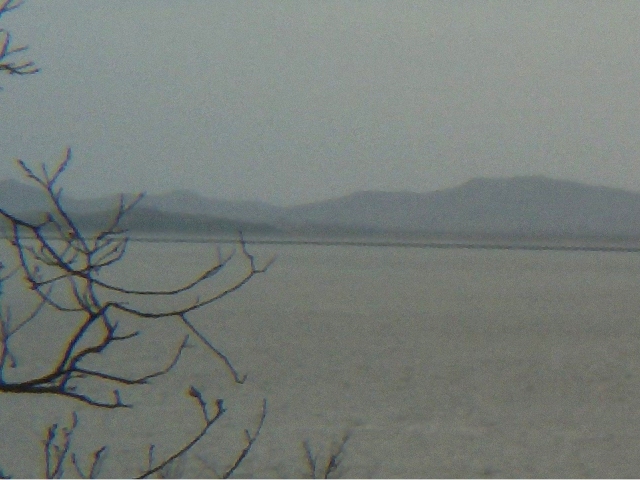
(visited by Wesley Woo-Duk Hwang-Chung) 13-Apr-2002 -- Because the last attempt was unsatisfactory (I ended up only photographing the South Korean land), I went onto try again. As outlined in the previous attempt, this confluence point cannot be explored successfully at any time in the near future due to the military standoff between the two Koreas. The most successful attempt one can expect would be to try photographing the confluence point from the border. This is what I wanted to do this time. Like last time, I took a series of buses and taxis, then a ferry to reach Gyodong island, the closest South Korean land to the confluence point in question. The military guard got a bit suspicious of me crossing the civilian-limit line twice in a week with no specific person on the island to visit to, but I managed to get around this problem. The weather was quite fine due to the rain last night, with more than 10km of view. The sand wind from China is still festering these days, but that rain cleared them up nicely. This was a chance I couldn't miss out on. Also, I left for this island early, so I had a lot more time to spare, unlike last time. As I found out, due to the popularity of owning a car in each household, the local bus that ran around the island shut down its operation a couple of years ago. Thankfully, I was able to hitchhike most of the way through the island and I came up to the shrine that laments for the families left on North Korea (picture #5). Naturally, this place had a clear view of the northern side of the border. Unfortunately, I was still 30.1km away from the confluence point, so I wanted to get more closer. Travelling north-west from the shrine, I was soon travelling along the coastline of the island. To defeat any spy invasions, it was fortified with barbed wires (picture #6). With a bit more walk, I came up to a warning sign that prohibits civilian crossing after dusk (picture #4). There was still a path that continued along the barbed wires so I decided go as far as I can. I realized that after a certain point, the forest got dense and my view to the north got severely blocked. So I stopped at about 29.3km south-east from the actual confluence point to photograph the view of the North Korean land containing the confluence point (picture #1). Thanks to the fine weather, the location was captured clearly as can be by my digital camera. Now I had fulfilled the promise I made at the last attempt; I was happy. I sincerely hope that the day when I am able to cross that sea and visit the confluence point comes soon. |
| All pictures |
| #1: Looking north-west; the confluence point can be reached by crossing this sea and travelling in a straight line for 29.32km. #2: Looking north; this is what one can see when looking east from the confluence point. The small town is faintly visible. #3: A snapshot of the GPS reading on the location. #4: The warning sign put up by the navy reads: "WARNING: This area is for military operation. Anyone or any boat approaching this area after dusk will be shot." #5: The shrine. There's a South Korean flag a the left of the picture looking towards North Korea. #6: Barbed wires prohibit the possible intrusion from across the sea. ALL: All pictures on one page |