|

China : Fújiàn Shěng
6.0 km (3.7 miles) N of Xiaozuo, Fújiàn, China
Approx. altitude: 0 m
(0 ft)
([?] maps: Google MapQuest OpenStreetMap ConfluenceNavigator)
Antipode: 25°S 61°W
Accuracy: 5 m (16 ft)
Quality: good
Click on any of the images for the full-sized picture.


| 25°N 119°E (visit #2) |
![Visit #1: [10-Mar-02]](/cn/all/n25e119/preview.jpg "Visit #1: [10-Mar-02]")

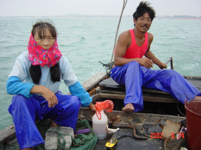
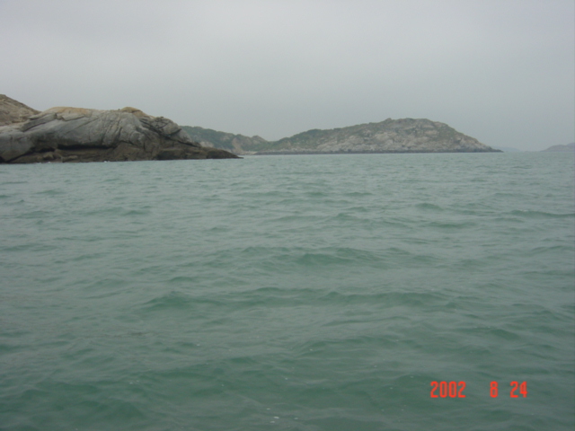
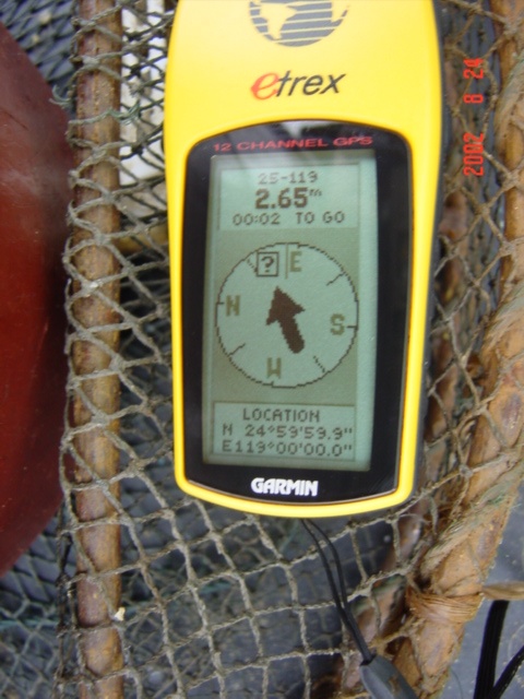
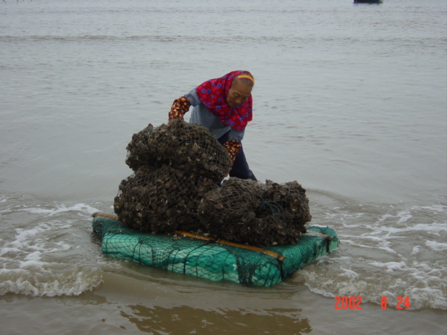
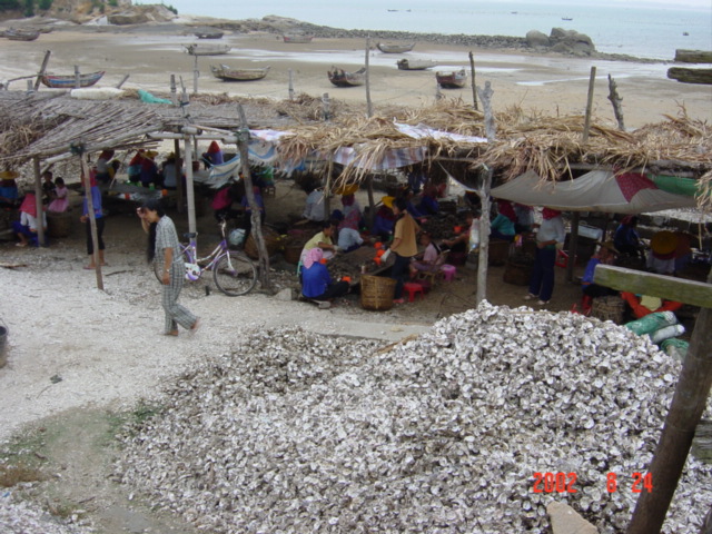
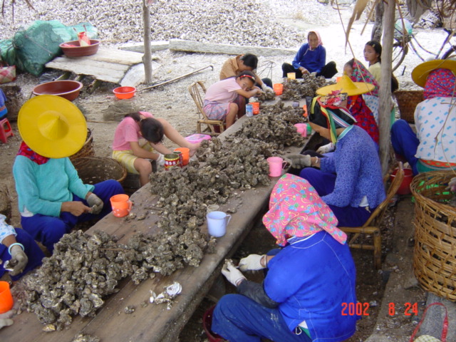
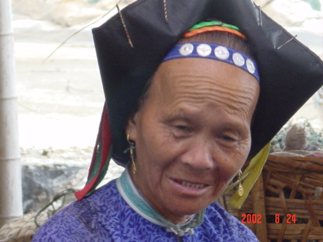
(visited by Targ Parsons) 24-Aug-2002 -- With all the confluences in neighbouring Guangdong Province already visited, there didn't seem to be any scope left for weekend confluence-hunting activities out of Hong Kong. At least, not until I made the chance discovery of four cross-border sleeper buses, plying the route between Hong Kong and various points in Fujian Province, departing every evening at 6:30 p.m., just a few short blocks from my office. Suddenly, a whole new area of China was opened up for short-duration, overland expeditions. So it was, after work on a Friday, that I set off for Fujian Province, with high hopes of bagging three or four confluences, and still making it back in time for work on Monday morning. As the bus made its way towards the mainland Chinese border, the large pink orb of the sun was disappearing into the chronic low-level haze, to be replaced in the sky by a full moon marking the start of the month-long Hungry Ghost Festival. At 1:45 a.m., everyone was suddenly woken up, and we all had to pile off the bus and eat a late night meal. This seems to be the Chinese way of doing things; if the trip's more than a few hours long, then you have to stop and eat, no matter what the time of day or night. The self-service food was pretty awful, but it was free. We were back on the road again half an hour later. I found it next to impossible to get back to sleep though, due to the constant stops our bus was obliged to make to pay tolls. It seemed like every little county through which the expressway runs had erected its own tollbooth, in order to cash in on the booty offered by the passing traffic. At 6:20 a.m., the bus reached Hui'an, which was where I had elected to disembark. Hui'an was the closest main town to my first destination, 22 kilometres to the east, a confluence already visited earlier this year by Greg Michaels and his friend. During one of Greg's Hong Kong stopovers, he had told me about how interesting his visit to this confluence had been, and I was privileged to see all the photos he had taken, not just the ones that are posted with his story. By first taking a bus to Jingfeng, then a motorbike to Zhangcuo, I managed to get to within two kilometres of the confluence in a matter of just over an hour. Then I promptly got lost in a maze of dwellings while trying to find my way to the beach. But after stopping to ask directions many times, I finally emerged onto a bluff overlooking the bay, with the confluence in the water just beyond a small rocky peninsular jutting out above a temple. I made my way down to the beach, where, for a nominal sum, I negotiated the use of a wooden boat belonging to a local couple. The wife waded out to the boat, towing me along behind her on a large floating rectangular slab of styrofoam. Once on board, the three of us motored the 1.3 kilometres out to the confluence, where the rocky peninsular was clearly visible a couple of hundred metres to the north. I managed to get a reading just 0.1 of a second from perfection, which is not bad for a waterborne confluence. After returning to dry land, I spent some time observing what the locals were engaged in: oyster farming. The large rectangular slabs of styrofoam, when not being employed for the transport of visiting confluence hunters, were used to ferry bag loads of oysters from boat to shore. Once on shore, the oysters were then carried on a shoulder yoke a short distance across the beach to a processing centre, where many local women, both young and old, were busy extricating the flesh from the shells. Most of the older women were clothed in traditional dress, including elaborate headwear. It was truly a very interesting confluence, but my time was limited, and I reluctantly tore myself away in order to continue my journey to the next objective, 25°N 118°E. |
| All pictures |
| #1: Rocky peninsular north of confluence. #2: Bluff overlooking the bay, with the confluence in the water just beyond the small rocky peninsular jutting out above the temple. #3: Local couple on their boat, motoring out to the confluence. #4: Reading just 0.1 of a second from perfection. #5: Oyster farming. #6: Large rectangular slabs of styrofoam are used to ferry bag loads of oysters from boat to shore. #7: Oysters are carried on a shoulder yoke a short distance across the beach to a processing centre. #8: The processing centre. #9: Many local women, both young and old, busy extricating the flesh from the shells. #10: Most of the older women were clothed in traditional dress, including elaborate headwear. ALL: All pictures on one page |
| Notes |
|
In the sea, about 300 m from land. |