|

China : Guǎngdōng Shěng
11.5 km (7.1 miles) ENE of Wushan (Húnán), Guǎngdōng, China
Approx. altitude: 995 m
(3264 ft)
([?] maps: Google MapQuest OpenStreetMap ConfluenceNavigator)
Antipode: 25°S 67°W
Accuracy: 6 m (19 ft)
Quality: good
Click on any of the images for the full-sized picture.


 to the west")


| 25°N 113°E (visit #2) |
![Visit #1: [16-Feb-02]](/cn/all/n25e113/preview.jpg "Visit #1: [16-Feb-02]")

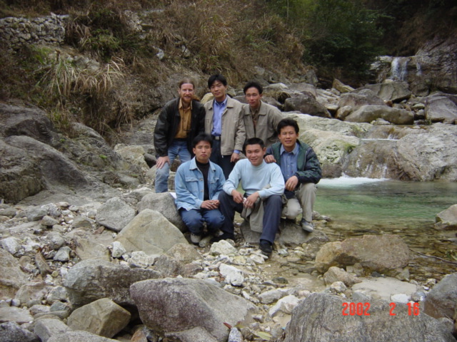
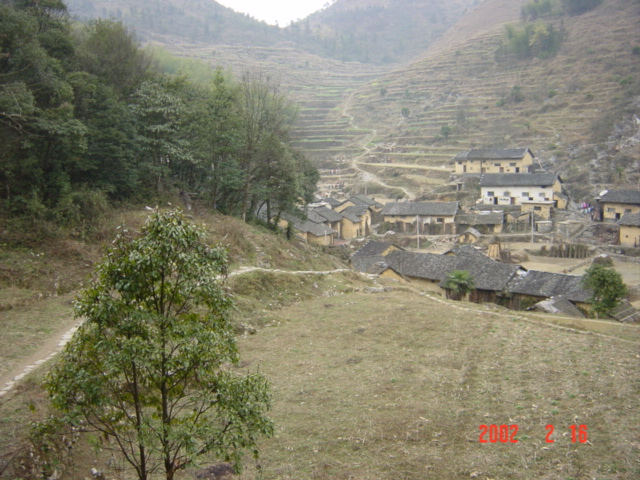
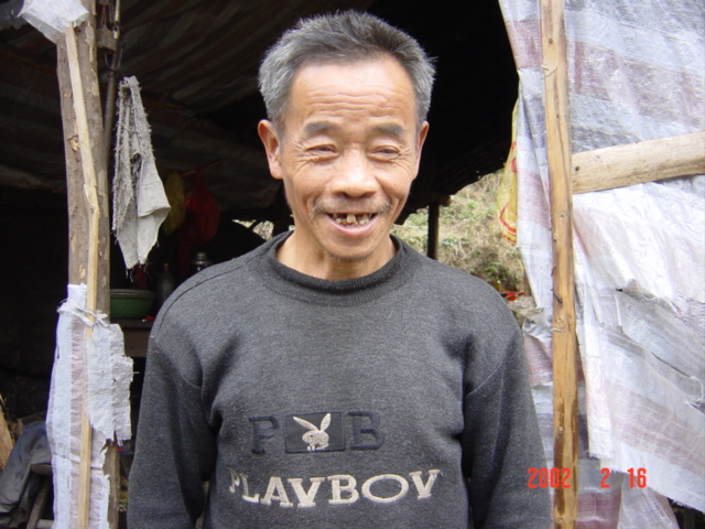
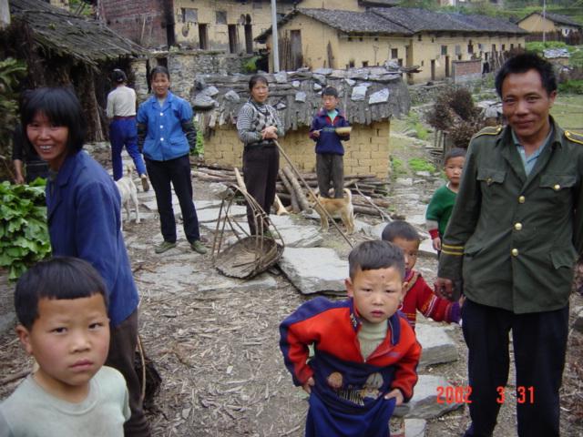
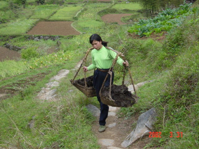
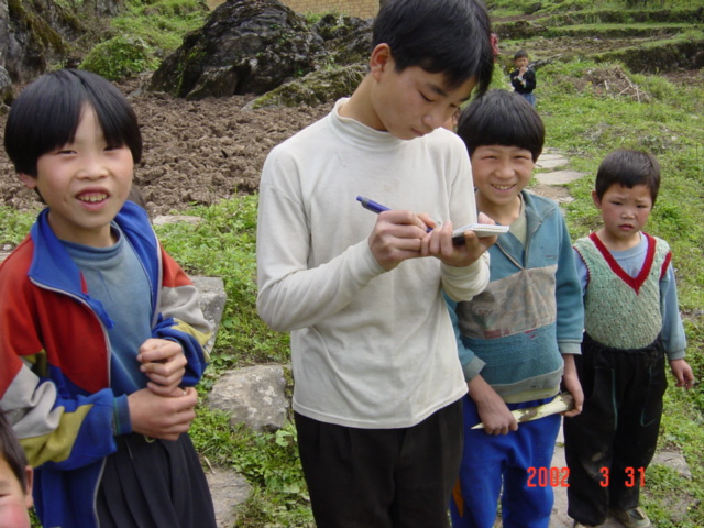
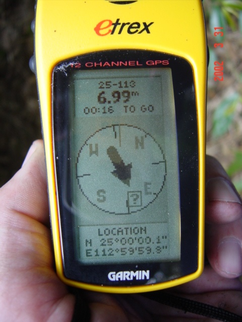
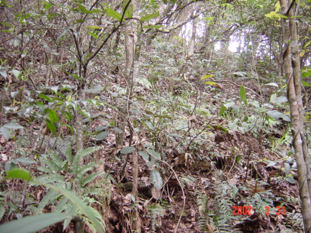
(visited by Targ Parsons) 31-Mar-2002 -- This story continues from 24°N 113°E. SATURDAY 30 MARCH 2002. Stopping for a few minutes at the home of my motorcyclist consumed just enough time to cause me to miss the last bus from Xinzhou back to Qingyuan. As we arrived in the Xinzhou town centre, I could see it receding into the distance! Never mind. I collected my backpack from the restaurant where I'd left it, then got my motorcyclist to take me out to the main road, where I figured I could probably wave down a passing bus. After a short wait, I was in fact able to do so. It was now 4:30 p.m. As I got on, I realised that I was the only passenger; there was no ticket seller, just the driver and me. The driver explained that he was actually off duty, but on his way to Qingyuan anyway, and that he was happy to give me a lift for free. He asked me where in Qingyuan I would like to be dropped off. I told him my plan was to get a bus from Qingyuan north to Shaoguan. He thought that there might be buses to Shaoguan from the old Qingyuan bus station, so we went there first. But once we arrived, a quick inquiry revealed that I needed to go to the *new* Qingyuan bus station across the other side of town in order to get a bus to Shaoguan. He insisted on taking me there -- all still free of charge! Just before 5:30 p.m., we arrived at the new Qingyuan bus station. As I was about to get out, the bus door jammed, and it took the driver several minutes to disassemble--and then reassemble--the door-opening mechanism, before I could finally get out. I went into the bus station only to discover that the last bus to Shaoguan for the day had departed just 30 seconds before! So I decided to switch tack, and try for a train to Pingshi instead. The nearest train station was quite some distance away, in a place called Yuantan. I waited about 10 minutes, then boarded a local commuter bus to Yuantan, arriving at the railway station at 6:15 p.m. I went inside the station, but found it to be completely devoid of people. Not a good sign! Over on one side of the empty station hall, I found a ticket window with someone on duty. I asked her if there were any trains to Pingshi, and if so, what time the next one would depart. She casually pointed in the direction of the tracks and said, "There's one now." Incredible luck! I quickly bought a ticket, then hopped on board just as it started rolling. The journey to Pingshi took three hours. There were no empty seats, but the train staff were really kind to me. They found me a table to sit at in the dining car, and kept me supplied with free tea and light conversation throughout the journey. Seeing as I was in the dining car, and I hadn't eaten since lunch, I also availed myself of the opportunity to eat some dinner before arriving in Pingshi. At 9:15 p.m. I disembarked in Pingshi, 30 odd kilometres north of the confluence, and checked into the hotel across the street from the station. The two pretty girls on the reception desk remembered me (and me them!) from when I had passed through after my first attempt at this confluence a month and a half before. After dumping my stuff in my room, I went out in search of a shop in order to buy a small backpack that I could take with me the next day. I wanted to be able to travel light, but still have enough supplies with me that I could spend a night or two in the mountains if need be. I was determined to succeed in reaching this confluence this time, even if it meant roughing it. I also rang Lin Ziguang in Meihua, as I had promised him I would. He was one of the group who had attempted this confluence with me the last time, front centre in this photo (picture #7 of previous attempt). Unfortunately, he had some family commitments the following day, so was unable to join me this time. Just before going to bed, I switched on the TV, and saw that one of the local stations was showing the movie adaptation of the book "Longitude" by Dava Sobel, which I thought was rather appropriate, given the task at hand! (Of course, the movie was dubbed into Chinese.) SUNDAY 31 MARCH 2002. After awaking to my alarm at 6 a.m., I checked out of the hotel, leaving my big backpack with reception, then took at passenger ute to Meihua, 23 kilometres north of the confluence. In Meihua, I stopped to eat breakfast, and to buy some fruit and water to take with me. I negotiated with a motorcyclist to take me to the village three kilometres east of the confluence, which I subsequently learned was called Zhongping (picture #8 of previous attempt). I arrived there at 9:15 a.m. I had understood from my last trip that the peasant affectionately known as "Playboy" (picture #6 of previous attempt) lived in this village, and so I had brought along a couple of large laminated photos to give him. But when I showed these photos of Playboy to the residents of Zhongping (picture #2), no one had ever heard of him! Well, never mind. I confirmed that the path leading off into the hills behind the village was indeed the path to Yanggouliao, and my map said Yanggouliao should be just over a kilometre north of the confluence, so I headed off in this direction. While still close to Zhongping, I passed many peasants carrying back-breaking loads up the steep path (picture #3). I encountered fewer and fewer people the further away I got, and eventually had the countryside pretty much to myself. After following the trail for about half an hour, I reached a mountain pass. On the other side, I could see another village in the distance (picture #4). I was still two kilometres east of the confluence, which is over the other side of the mountain ridge at the extreme top left of the photo. I assumed that this village must be Yanggouliao, wrongly as it turned out. Once in the village, I learned from a young lad that it was actually named Maoping. He wrote the Chinese characters for "Maoping" in my notebook (picture #5). He also explained that Yanggouliao was a bit further on, but it was not in the direction that my GPS was now telling me to go. Before continuing on my way, on a hunch I pulled out the photos of Playboy, and showed them to the ever-growing group of children encircling me. They all immediately recognised him. It turns out he lived in Maoping, although he was not in the village at that moment. I entrusted the photos to the lad, who promised to deliver them to Playboy upon his return. I then set off towards the confluence on my own -- the entourage of children conveniently distracted by the glossy photos in the hands of the lad. The weather was gorgeous: sunny and hot. By 11:30 a.m., I had climbed up to a mountain ridge offering spectacular 360° views of the surrounding landscape. I was at an elevation of 1,180 metres. To the west was the Babaoshan range (picture #6), and to the north I could see what must have been the village of Yanggouliao nestled among the hills (picture #7). I was still approximately 300 metres east of the confluence. From here on, the slopes were extremely precipitous -- one wrong move and I would have been a goner. I chose my footing very carefully indeed, occasionally going down on all fours to reduce the chance of losing my balance. The only way to make progress was along the crests, and I was faced with two crests from which to choose. It was decidedly unclear which crest would take me closest to the confluence. I started down the crest on my left, but after a while decided to backtrack and climbed back up, convinced that I had made the wrong choice. Then I went down the crest on my right. This got me to 156 metres from the confluence--not good enough! It was now obvious that my original decision, to follow the crest on the left, had been the correct one after all. So up I climbed once more, then back down the left crest. All this was incredibly time-consuming, not too mention energy-sapping. And the weather was starting to become overcast. The last thing I needed was for the heavens to open up while I was out here, marooned on a mountaintop! But finally, at 1:15 p.m., I had reached a point just a few dozen metres above the confluence. I left the crest I'd been following, and very carefully made my way down the steep slope, holding onto the trees for dear life. The trees were tall and densely foliated, which caused the GPS to fluctuate wildly, between wildly fluctuating readings and no readings at all. I did the best I could to get all the zeroes, but in the end it simply wasn't possible (picture #8). Elevation: 1,004 metres. The view facing south gives some idea of conditions at the confluence point (picture #1). A nearby tree sported a good growth of fungi, called "mu'er" in Chinese, which literally translates as "tree ears" (picture #9). I scrambled my way back up the few dozen metres to the crest of the hill, then sat down to relax, eat the lunch I'd brought with me, and reflect upon the fact that all the confluence points in Guangdong province had now been successfully visited. I started on my journey back just before 2 p.m., passing through Maoping, and finally reaching Zhongping at 3:20 p.m. The village was now pretty devoid of people, but I found one friendly lady and imposed myself upon her for some badly needed tea (picture #10). Sufficiently rehydrated, I left Zhongping on foot in the direction of Shaping, 10 kilometres to the north. It was two hours later before I encountered any traffic. I was then able to get a lift the final few kilometres to Shaping, then to Meihua, then finally back to Pingshi, arriving just before 7 p.m. This story continues at 26°N 113°E. |
| All pictures |
| #1: Facing south #2: Residents of Zhongping #3: Back-breaking work #4: Village of Maoping visible in the distance #5: A young lad writes "Maoping" in my notebook #6: Babaoshan (Eight-Treasure Mountains) to the west #7: The village of Yanggouliao, visible among the hills to the north #8: Couldn't quite get a perfect reading #9: A nearby tree with Mu'er fungi #10: Tea with a friendly lady ALL: All pictures on one page |